Preah Vihear Province
| Preah Vihear ព្រះវិហារ | |
|---|---|
| Province | |
 Prasat Preah Vihear | |
 Map of Cambodia highlighting Preah Vihear | |
| Coordinates: 13°47′N 104°58′E / 13.783°N 104.967°ECoordinates: 13°47′N 104°58′E / 13.783°N 104.967°E | |
| Country |
|
| Provincial status | 1959 |
| Named for | Preah Vihear Temple |
| Capital | Preah Vihear |
| Government | |
| • Governor | Un Chanda (CPP) |
| Area | |
| • Total | 13,788 km2 (5,324 sq mi) |
| Area rank | Ranked 3rd |
| Population (2008)[1] | |
| • Total | 170,852 |
| • Rank | Ranked 19th |
| • Density | 12/km2 (32/sq mi) |
| • Density rank | Ranked 23rd |
| Time zone | UTC+7 (ICT) |
| Dialing code | +855 |
| ISO 3166 code | KH-13 |
| Districts | 7 |
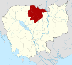
Preah Vihear (Khmer: ព្រះវិហារ, IPA: [preə̯̆h ʋihiə]; "Sacred Sanctuary") is a province (khaet) of Cambodia. It borders the provinces of Oddar Meanchey and Siem Reap to the west, Kampong Thom to the south and Stung Treng to the east. Its northern boundary forms part of Cambodia's international border with Thailand and Laos. Its capital is Preah Vihear.
Description
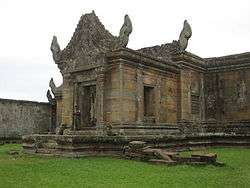
The province is named after the temple of Prasat Preah Vihear. The Dângrêk Mountains and the Cambodia/Thailand border are located in the north of Preah Vihear Province.
Preah Vihear is one of the nine provinces that are part of the Tonle Sap Biosphere Reserve.[2]
Several Western governments have issued travel warnings to their citizens advising not to travel to this province due to an ongoing border dispute between Cambodia and Thailand. The Government of Canada has advised "Armed forces from both countries are engaged in this ongoing dispute. There have been reports of exchanges of gunfire in the area. Tensions are extremely high and military hostilities could escalate without warning." [3]
Administrative divisions
The province is subdivided into 7 districts.
| ISO Code | District | Romanization |
|---|---|---|
| 1301 | ជ័យសែន | Chey Saen |
| 1302 | ឆែប | Chhaeb |
| 1303 | ជាំក្សាន្ត | Choam Khsan |
| 1304 | គូលែន | Kuleaen |
| 1305 | រវៀង | Rovieng |
| 1306 | សង្គមថ្មី | Sangkom Thmei |
| 1307 | ត្បែងមានជ័យ | Tbeng Meanchey |
Sites
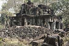
- Koh Ker complex: Koh Ker was once the capital city of Khmer Empire
- Bakan or Preah Khan Kompong Svay complex: 105 kilometres southwest of the provincial town, built under the reign of King Suryavarman I (1002–1050)
- Noreay Temples: five 7th-century temples made of Sandstone, laterite and brick, 32 kilometres northeast of the town.
- Phnom Pralean temple: a temple built to worship Brahmanism, on top of a 180 metres hill
- Neak Buos temple: 75 kilometres north of Tbaeng Meanchey
- Krapum Chhouk temple: built in the 10th century in laterite and stone, 45 kilometres south of Tbaeng Meanchey
- Kork Beng temple: a ruined laterite and sandstone temple built between 936 and 951 by a commander named Kork on the order of King Jayavarman IV
- Wat Peung Preah Ko: a place of worship in beautiful natural surroundings believed to possess strong supernatural powers.
- Preah Vihear Temple: built in the 12th century, located between Thailand and Cambodia. It was listed as World Heritage Site in 2008.


References
- ↑ "General Population Census of Cambodia 2008 - Provisional population totals" (PDF). National Institute of Statistics, Ministry of Planning. 3 September 2008.
- ↑ "Tsbr-ed.org". www.tsbr-ed.org. Retrieved 17 April 2018.
- ↑ Canada, Gouvernement du Canada, Affaires étrangères et Commerce international. "Erreur 404 - Voyage.gc.ca". Voyage.gc.ca. Retrieved 17 April 2018.
External links
- Preah-Vihear.com - Preah Vihear Temple and the Thai's Misunderstanding of the World Court Judgment of 15 June 1962

Places adjacent to Preah Vihear Province | |
|---|---|
| Provinces | ||
|---|---|---|
| Municipalities | ||
| Capital city | | |
|---|---|---|
| Districts | ||