Errol, Perth and Kinross
| Errol | |
|---|---|
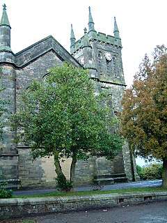 Errol Parish Church | |
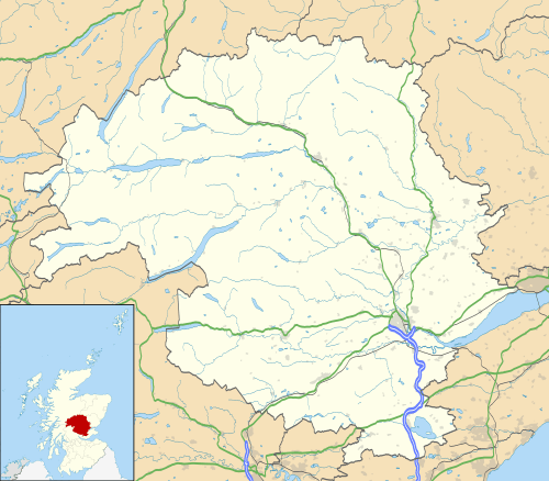 Errol Errol shown within Perth and Kinross | |
| Population | 1,280 (2008) |
| OS grid reference | NO252228 |
| Council area | |
| Lieutenancy area | |
| Country | Scotland |
| Sovereign state | United Kingdom |
| Post town | PERTH |
| Postcode district | PH2 |
| Dialling code | 01821 |
| Police | Scottish |
| Fire | Scottish |
| Ambulance | Scottish |
| EU Parliament | Scotland |
| UK Parliament | |
| Scottish Parliament | |
Errol is a village in Perth and Kinross, Scotland about halfway between Dundee and Perth. It is one of the principal settlements of the Carse of Gowrie.
Errol is known for its reeds, which used to be collected up to a few years ago to make thatched roofs. These reeds grow in the banks of the River Tay and act as home to a fairly uncommon bird called the bearded tit. Errol has a large church, built in 1831, known as the "Cathedral of The Carse" which can be seen from most parts of the village and from far around.
Errol is also known for its local brick factory. Nowadays sadly closed. The premises have been taken over and modernised by the Mackie's Crisps company which incorporates a "factory shop" where locals can purchase their produce. It also has a scenic farm track to walk or bike down, right beside the beautiful River Tay. While walikng down the track you will find a rope swing which almost swings over the river. It is perfect for walking dogs,
Errol Primary School is over a century old and is where many local children go to learn,it has been extended twice as more pupils attend. Errol has two general grocery shops; other local amenities include a chip shop (which has been closed for several months (Sep 2018) but due to reopen soon) a post office, one pub (was also a restaurant but no longer) a community centre, (the doctors' surgery is now closed but a new surgery is due to open just outside the village at West Leys) pharmacy and hairdresser. The local winery Cairn O'Mohr has won many awards for its wines made from local produce such as oak sap, rhubarb and brambles and is situated on the same farmyard as Gillies & Mackay Ltd, a local shed company.

Errol lies on the National Cycle Network NCN 77 from Dundee to Pitlochry and is situated about a mile from the A90 Perth to Dundee Road. This makes it popular for people who commute to work. Errol is surrounded by agricultural flat fields and has a prominent attractive location within this setting.
The site of the wartime RAF Errol airfield is situated approximately one mile east of the village. It hosts the Errol car boot sale every Saturday and Sunday, bringing in many people from surrounding areas including Perth and Dundee.
The village had a railway station on the line between Perth and Dundee until the mid-1980s. British Rail announced its decision to close it on 30 September 1985.[1]
The Errol Parish Church, completed in 1833, is a Category A Listed Building.
Errol is twinned with Mardié, a village on the Loire near Orléans in France.[2]
See also
References
- ↑ "List of dates from 1 January 1985 to 20 January 2006 of last passenger trains at closed BR (or Network Rail stations since privatisation)". Department for Transport Website: Freedom of Information Act responses, February 2006. Department for Transport. 2006. Archived from the original on 2008-11-08. Retrieved 2008-08-09.
- ↑ "ErrolVillage Information". Retrieved 15 July 2012.
External links
| Wikimedia Commons has media related to Errol, Perth and Kinross. |
- Map sources for Errol, Perth and Kinross
- Errol Church
- Errol Primary School
- Carse of Gowrie Weather
- Errol Village Web-site
- Gillies & Mackay Ltd