Alyth
Alyth
| |
|---|---|
 Alyth Church | |
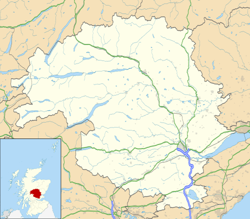 Alyth Alyth shown within Perth and Kinross | |
| Population | 3,193 |
| OS grid reference | NO245486 |
| Council area | |
| Lieutenancy area | |
| Country | Scotland |
| Sovereign state | United Kingdom |
| Post town | BLAIRGOWRIE |
| Postcode district | PH11 |
| Dialling code | 01828 |
| Police | Scottish |
| Fire | Scottish |
| Ambulance | Scottish |
| EU Parliament | Scotland |
| UK Parliament | |
| Scottish Parliament | |
Alyth (Gaelic: Ailt) is a town in Perth and Kinross, Scotland, situated under the Hill of Alyth five miles northeast of Blairgowrie. In 2001 the town had a population of 2,963.[1]
The settlement of New Alyth lies on the A926 road southwest of the main village.
Education
Alyth has a primary school that has around 497 pupils. Alyth High School catered for pupils up to fourth year until it was closed in 1994, when all pupils were moved to Blairgowrie High School or Webster's High School situated in nearby Kirriemuir.
Geography
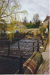
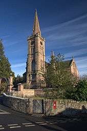
Alyth is located on a burn which bears its name and owes its position to a confluence of drovers' roads used by hill farmers to bring their sheep and cattle down to market. A picturesque 17th century packhorse bridge is among a number of stone bridges[2] crossing the burn in the town. The ruins of the old church, known locally as The Arches, stand in a graveyard in a prominent position at the top of the town. The current church building, completed in 1839 to the design of Edinburgh architect, Thomas Hamilton, dominates the skyline of the town. It is Gothic in style, with Romanesque influences, especially in the windows, and has an unusually high spire. Inside the church is the funerary hatchment of Sir George Ramsay (sixth baronet of Bamff) who was killed in a duel at Musselburgh, in April 1790 - one of the last duelling deaths in Scotland. In the church porch is preserved a late 7th-early 8th century Pictish cross-slab, with a decorated cross on one face and a single Pictish symbol ('double disc and Z-rod') on the other. It was discovered in Alyth in 1887 when ground was being levelled in front of the manse.
History and Archaeology
To the northeast of the town a hill fort, possibly of Pictish date, stands atop Barry (or 'barrow') Hill. The remains consist of massive collapsed stone ramparts that take advantage of the topography of the Alyth Hill. Local legend connects the fort with King Arthur, and it is claimed that Guinevere, Arthur's queen, was imprisoned here for a very short time.
Another nearby early medieval feature is a Pictish 'Class I' symbol stone in a field on Bruceton Farm somewhat to the east of Alyth. This slab is one of relatively few likely still to be in its original position. It may have marked an ancient burial.
There may have been a Christian presence in this area from early times, since the medieval parish church was dedicated to St. Moluag of Lismore (d. 592), a contemporary of St. Columba. The cross-slab mentioned above also suggests this.
Alyth was granted a Charter by James III in 1488, raising Alyth to the rank of Burgh of Barony with the right to hold markets and fairs.
Archaeological Excavation of a souterrain - Shanzie Farm


A late British Iron Age souterrain was excavated by a team of Headland Archaeology[3] in Shanzie Farm, c 3.5. north-east of Alyth.[4] The underground structure was roughly C-shaped in plan and measured c 35 metres in length. There was a single chamber c 5m long and an entrance to the south-east. For the most part, the souterrain had been badly plough truncated and the walls survived as a single course. The northern terminal of the souterrain was better preserved, where 3-4 courses of wall survive. The chamber here narrowed and had been filled with rubble to a depth. The walls also started to corbell inwards indicating this was originally a stone-capped structure rather than timber roofed. No evidence of an associated settlement or any other surface features were identified; these have undoubtedly been lost to the plough. The structure is typical of the 'southern Pictland group' [5]
The souterrain had clearly been broken into during the Victorian period, but also, during medieval times. Finds included several types of late prehistoric pottery, a fragment of probable Roman pottery, an amber ring, a pair of tweezers, a brooch or clasp, two copper alloy rings and a fragment from a quern stone. The souterrain was partially backfilled allowing visitors to see the structure in plan.
Culture
A golf club was established in Alyth in 1894. The original nine-hole course was designed by Old Tom Morris of St. Andrews and was modified and extended to 18 holes by James Braid in 1934. A further two clubs have opened since, the Strathmore Golf Centre (1986) with an 18- and a 9-hole course, and the Glenisla Club in 1992.
The town has a small local museum, open from May through September, which is run by Perth Museum. This has access to the Arches, the oldest buildings in Alyth which stand on the site of the 6th Century church of Saint Moluag.
Alyth has also been home to many Traditional Folk Singers including the late Sheila Stewart and Folk Trio Bob, Tony & Paddy Stewart.
See also
References
- ↑ Comparative Population Profile: Alyth Locality Archived 2012-02-23 at the Wayback Machine.
- ↑ Neil Wilson and Alan Murphy, Scotland, 2004, 444 pages ISBN 1-74104-156-2
- ↑ Coleman, R and Hunter, F (2002) "The excavation of a souterrain at Shanzie Farm, Alyth, Perthshire" Tayside and Fife Archaeological Journal vol 8 (2002), 77-101.
- ↑
- ↑ Wainright, F.T. (1963) The Souterrains of Southern Pictland London.
External links
| Wikimedia Commons has media related to Alyth. |
| Authority control |
|---|