South Lanarkshire
| South Lanarkshire Sooth Lanrikshire Siorrachd Lannraig a Deas | |||
|---|---|---|---|
 | |||
| |||
| Coordinates: 55°36′N 3°47′W / 55.600°N 3.783°WCoordinates: 55°36′N 3°47′W / 55.600°N 3.783°W | |||
| Admin HQ | Hamilton | ||
| Government | |||
| • Body |
South Lanarkshire Council Almada Street Hamilton South Lanarkshire ML3 0AA southlanarkshire.gov.uk | ||
| • Control | SNP minority (council NOC) | ||
| • MPs | |||
| • MSPs | |||
| Area | |||
| • Total | 684 sq mi (1,772 km2) | ||
| Area rank | Ranked 11th | ||
| Population (mid-2017 est.) | |||
| • Total | 318,200 | ||
| • Rank | Ranked 5th | ||
| • Density | 460/sq mi (179/km2) | ||
| ONS code | S12000029 | ||
| ISO 3166 code | GB-SLK | ||
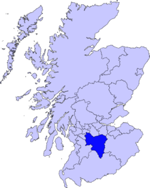
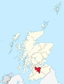
South Lanarkshire (Scots: Sooth Lanrikshire; Scottish Gaelic: Siorrachd Lannraig a Deas) is one of 32 unitary authorities of Scotland. It borders the south-east of the City of Glasgow and contains some of Greater Glasgow's suburbs. It also contains many towns and villages. It also shares borders with Dumfries and Galloway, East Ayrshire, East Renfrewshire, North Lanarkshire, the Scottish Borders and West Lothian. It includes part of the historic county of Lanarkshire.
South Lanarkshire Council
South Lanarkshire Council has its headquarters in Hamilton, has 16,000 employees, and a budget of almost £1bn. The large and varied geographical territory takes in rural and upland areas, market towns such as Lanark, Strathaven and Carluke, the urban burghs of Rutherglen, Cambuslang, and East Kilbride which was Scotland's first new town.
There are 20 council wards in South Lanarkshire,[1] each serving a population ranging from 12,000 to 19,000[2] and each ward represented on the council by 3 or 4 elected councillors using single transferable vote. South Lanarkshire operates a cabinet style system, with key decisions being taken by the Executive Committee, under the leadership of the Council Leader, and approved by the council, led by the provost.
South Lanarkshire shares borders with the unitary authorities of Dumfries and Galloway, East Ayrshire, East Renfrewshire, City of Glasgow, North Lanarkshire, West Lothian and Scottish Borders.
The area was formed in 1996, from the areas of Clydesdale, Hamilton and East Kilbride districts, and some outer areas of Glasgow District (Rutherglen/Fernhill, Cambuslang/Halfway and part of King's Park/Toryglen).
Political composition
| Party | Councillors | |
| Scottish National Party | 25 | |
| Labour | 17 | |
| Conservative | 14 | |
| Independent | 6 | |
| Liberal Democrats | 1 | |
Council Headquarters

The Council Headquarters building, on Almada Street, Hamilton, was built as the Lanark County Buildings in 1963, and designed by Lanark council architect D G Bannerman. The 16 storey, 165 foot tower is the largest in Hamilton, and is a highly visible landmark across this part of the Clyde Valley. The modernist design was influenced by the United Nations building in New York. Glass curtain walls cover the north and south facades, with the narrow east and west sides being blank white walls. At the front of the building is the circular council chamber, and a plaza with water features. It is known by locals as the "County Buildings".
Towns and villages
Principal settlements (and populations[4])
- Blantyre – 16,900
- Cambuslang – 29,100
- Carluke – 13,320
- East Kilbride – 75,120
- Hamilton – 54,080
- Lanark – 9,050
- Larkhall – 14,740
- Rutherglen – 31,190
- Strathaven – 7,350
Other settlements
- Abington
- Ashgill
- Auchengray
- Auchenheath
- Auldhouse
- Biggar
- Blackwood
- Bothwell
- Braehead
- Braidwood
- Carmichael
- Carnwath
- Carstairs
- Chapelton
- Cleghorn
- Climpy
- Coalburn
- Cobbinshaw
- Coulter
- Crawford
- Crawfordjohn
- Crossford
- Dalserf
- Dolphinton
- Douglas
- Douglas Water
- Elsrickle
- Elvanfoot
- Forth
- Glassford
- Glespin
- Jackton
- Kilncadzow
- Kirkfieldbank
- Kirkmuirhill
- Law Village
- Leadhills
- Lesmahagow
- Newbigging
- Nerston
- Pettinain
- Quarter
- Quothquan
- Rigside
- Roberton
- Rosebank
- Sandford
- Stonehouse
- Symington
- Tarbrax
- Thankerton
- Thorntonhall
- Uddingston
- Unthank
- Waterfoot (Part Of)
- Wilsontown
- Wiston
- Woolfords
Places of interest
- Hamilton Mausoleum
- Bothwell Castle
- Strathaven Castle
- John Hastie Museum, Strathaven
- Low Parks Museum, Hamilton
- Rutherglen Town Hall and medieval church tower
- Chatelherault Country Park, near Hamilton, including Cadzow Castle
- Craignethan Castle
- David Livingstone Centre, in Blantyre
- Dollan Baths, East Kilbride
- Falls of Clyde
- Little Sparta, near Dunsyre near Lanark
- New Lanark, a World Heritage Site
- Clyde Valley
- Sites of the Battle of Drumclog and the Battle of Bothwell Bridge
- Wilsontown Ironworks
Tertiary education
- South Lanarkshire College
- University of the West of Scotland (formerly Bell College, University Of Paisley)
See also
References
- ↑ "Local multi-member ward boundary maps". South Lanarkshire Council. 4 May 2017. Retrieved 23 July 2018.
- ↑ "South Lanarkshire". City Population. 30 June 2016. Retrieved 23 July 2018.
- ↑ "Political composition of the council". Retrieved 13 September 2018.
- ↑ “Mid-2016 Population Estimates for Settlements and Localities in Scotland”, National Records of Scotland
External links
- South Lanarkshire Council homepage
- South Lanarkshire at Curlie (based on DMOZ)