Mount Paiko
| Mount Paiko | |
|---|---|
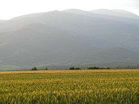 A view of Mount Paiko. | |
| Highest point | |
| Elevation | 1,650 m (5,410 ft) [1] |
| Coordinates | 40°57′11.51″N 22°20′8.98″E / 40.9531972°N 22.3358278°ECoordinates: 40°57′11.51″N 22°20′8.98″E / 40.9531972°N 22.3358278°E [2] |
| Geography | |
 Mount Paiko Location of Mount Paiko | |
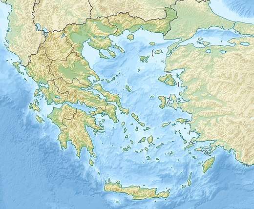
| Location | Greece |
| Parent range | Central Macedonia |
Mountain Paiko or Pajak in Bulgarian and Macedonian is a small mountain range (surface area:399 km2[3]) that lies on the border of Pella and Kilkis regional units in Central Macedonia, Greece.[4][5]
Geography
Morphologically, Paiko is a curvy extension to the NE of the adjacent Voras mountain range. Together they surround the plain of Aridea. East and south of Paiko are the plains of the Vardar (Axios) river and the plains of Giannitsa respectively.
The highest peaks are Skra (1097 m), Tsouma (1219 m), Vertopia (1490 m), Pirgos (1494 m), Kadasti (1607 m) and Ghola Tsouka (1650 m). Pirgos, Vertopia and Kadasti surround a large plateau (formerly native grassland) at altitude around 1200 m. Most areas of the plateau are residential or cultivated.[5][6]
Geology
Paiko is composed of igneous and sedimentary rocks, mainly carbonatite and ophiolite. Sedimentary rocks are found mostly in NE areas.[6][7]
Hydrology
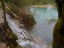
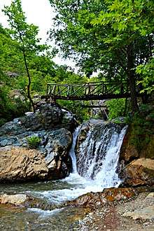
Paiko is rich in surface as well as underground bodies of water, often potable. Springs exist at the foothills and small wetlands can be found at high altitudes, connected by several streams. Two waterfalls and a lagoon of blue-green waters are located near the Skra peak.[6][5][8]
East of the mountain is a small artificial lake (Lake Metalleiou) 35 m deep and of circumference around 4 km.[9]
Life
Flora
The vegetation of Paiko is considered lush.[5] Genera of large trees include:[5][10][11][12]
- pine
- Quercus (Oak) (especially Quercus pubescens and Quercus frainetto)
- plane (especially Platanus orientalis)
- alder (especially Alnus glutinosa)
- beech
- walnut
- chestnut
- cedrus
- willow
- populus
- apple trees
Smaller plants and fungi include:[5]
- Species of grass.
- Shrubs such as wild strawberries.
- Mushrooms. A rare species (Daedaleopsis septentrionalis) known only in northern areas was discovered in 2009.[13]
- Fern.
- Flowers like Primula vulgaris, Scilla bifolia, Viola odorata, Galanthus elwesii and Crocus veluchensis.
Fauna
Except mammals (deers, rabbits) and vultures, notable animals include:[6]
- Amphibians such as the Great Crested Newt and the Yellow-bellied toad.
- Reptiles such as Hermann's Tortoise.
- The fish Sabanejewia aurata and the rare Mediterranean Barbel.
- Lepidoptera (57 species have been identified[14]) such as the Large Copper butterfly and the Callimorpha quadripunctata moth.
At Metalleiou lake humans have introduced trout. Fishing is allowed under controlled conditions.[8]
See also
References
- ↑ "Archived copy". Archived from the original on 2011-07-16. Retrieved 2010-04-28.
- ↑
- ↑ http://www.goumenissa.gr/index.php?option=com_content&task=view&id=173&Itemid=241
- ↑ Google Earth
- 1 2 3 4 5 6 "Archived copy". Archived from the original on 2011-07-17. Retrieved 2010-04-28.
- 1 2 3 4 "Archived copy". Archived from the original on 2011-07-16. Retrieved 2010-04-28.
- ↑ http://www.e-city.gr/kilkis/home/view/1302.php
- 1 2 "Archived copy". Archived from the original on 2010-04-27. Retrieved 2010-04-29.
- ↑ http://www.agrotravel.gr/agro/site/AgroTopics/t_docpage?sparam=interests&doc=/Documents/Agrotravel/learnabout/Kilkis/limnimetalleiou&sub_nav=LearnAbout
- ↑ "Archived copy". Archived from the original on 2011-07-16. Retrieved 2010-04-28.
- ↑ http://www.nagref.gr/journals/de/de19_59.pdf
- ↑ "Archived copy" (PDF). Archived from the original (PDF) on 2011-07-21. Retrieved 2010-04-29.
- ↑ http://www.ethnos.gr/article.asp?catid=11900&subid=2&pubid=5454851
- ↑ http://news.kathimerini.gr/4dcgi/_w_articles_ell_2_19/03/2005_137790