Parsa (village)
| Parsa पर्सा Phadi-Parsa | |
|---|---|
| Village development committee | |
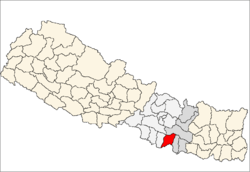
 Parsa Location in Nepal | |
| Coordinates: 26°53′0″N 85°38′0″E / 26.88333°N 85.63333°ECoordinates: 26°53′0″N 85°38′0″E / 26.88333°N 85.63333°E | |
| Country |
|
| Zone | Janakpur Zone |
| District | Sarlahi District |
| Population (1991) | |
| • Total | 3,943 |
| Time zone | UTC+5:45 (Nepal Time) |
Parsa is a village development committee in Sarlahi District in the Janakpur Zone of south-eastern Nepal. At the time of the 1991 Nepal census it had a population of 3943 people living in 666 individual households.
Bounderies
East- Narayanpur, Kabilashi
East South- Indian border
South- Indian border
South West- India border
West- Sakhuwaba
West North- Nokailwa
North- Pipara
North West- Dhankaul, Jingarwa
References
- ↑ "Nepal Census 2001". Nepal's Village Development Committees. Digital Himalaya. Archived from the original on October 12, 2008. Retrieved 2 November 2008.
External links
This article is issued from
Wikipedia.
The text is licensed under Creative Commons - Attribution - Sharealike.
Additional terms may apply for the media files.