Ožďany
| Ožďany | |
| Village | |
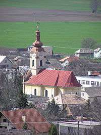 General view on Ožďany | |
| Country | Slovakia |
|---|---|
| Region | Banská Bystrica |
| District | Rimavská Sobota |
| Elevation | 213 m (699 ft) |
| Coordinates | 48°23′N 19°54′E / 48.383°N 19.900°ECoordinates: 48°23′N 19°54′E / 48.383°N 19.900°E |
| Area | 37.172 km2 (14.35 sq mi) |
| Population | 1,629 (2011) |
| Density | 44/km2 (114/sq mi) |
| First mentioned | 1332 |
| Postal code | 980 11 |
| Area code | +421-47 |
| Car plate | RS |
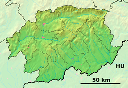 Location of Ožďany in the Banská Bystrica Region  Ožďany (Slovakia) | |
| Statistics: MOŠ/MIS | |
| Website: www.obecozdany.sk | |
Ožďany is a village and municipality in the Rimavská Sobota District of the Banská Bystrica Region of southern Slovakia. Local high school played an important role in the Slovak history, some important persons of Slovak literary and political life of the 19th century made their studies here, like Štefan Marko Daxner, Ján Botto and Ján Francisci-Rimavský. Nearby cities and villages : Hrnčiarske Zalužany, Husiná and Kružno. In the village are located gym hall, football pitch, kindergarten and elementary school. Most important sightseeings are evangelical and Roman Catholic church, manor houses and historical mill.
External links
This article is issued from
Wikipedia.
The text is licensed under Creative Commons - Attribution - Sharealike.
Additional terms may apply for the media files.