Hrachovo
| Hrachovo | |
| Municipality | |
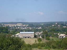 View on Hrachovo | |
| Country | Slovakia |
|---|---|
| Region | Banská Bystrica |
| District | Rimavská Sobota |
| Elevation | 273 m (896 ft) |
| Coordinates | 48°27′49″N 19°57′02″E / 48.46361°N 19.95056°ECoordinates: 48°27′49″N 19°57′02″E / 48.46361°N 19.95056°E |
| Area | 11.844 km2 (4.57 sq mi) |
| Population | 340 (2011) |
| Density | 29/km2 (75/sq mi) |
| First mentioned | 1353 |
| Postal code | 980 52 |
| Area code | +421-47 |
| Car plate | RS |
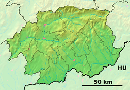 Location of Hrachovo in the Banská Bystrica Region  Hrachovo (Slovakia) | |
| Statistics: MOŠ/MIS | |
| Website: www.hrachovo.ocu.sk | |
Hrachovo (former name: Hrachou) is a village and municipality in the Rimavská Sobota District of the Banská Bystrica Region of southern Slovakia. The most important sightseeings are classical churches, evangelical and Roman Catholic, manor house and the castle, which is now in ruins.
Genealogical resources
The records for genealogical research are available at the state archive "Statny Archiv in Banska Bystrica, Slovakia"
- Roman Catholic church records (births/marriages/deaths): 1769-1851 (parish A)
- Greek Catholic church records (births/marriages/deaths): 1713-1883 (parish A)
See also
External links
- Hrachovo castle information
- http://www.e-obce.sk/obec/hrachovo/hrachovo.html
- Surnames of living people in Hrachovo
This article is issued from
Wikipedia.
The text is licensed under Creative Commons - Attribution - Sharealike.
Additional terms may apply for the media files.