Drienčany
| Drienčany | |
| Village | |
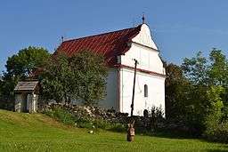 Protestant church in Drienčany | |
| Country | Slovakia |
|---|---|
| Region | Banská Bystrica |
| District | Rimavská Sobota |
| Elevation | 229 m (751 ft) |
| Coordinates | 48°28′N 20°04′E / 48.467°N 20.067°ECoordinates: 48°28′N 20°04′E / 48.467°N 20.067°E |
| Area | 11.002552 km2 (4.25 sq mi) |
| Population | 248 (2011) |
| Density | 23/km2 (60/sq mi) |
| First mentioned | 1291 |
| Postal code | 980 23 |
| Area code | +421-47 |
| Car plate | RS |
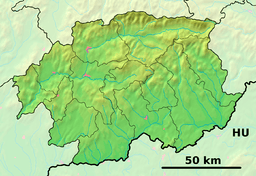 Location of Drienčany in the Banská Bystrica Region  Drienčany (Slovakia) | |
| Statistics: MOŠ/MIS | |
| Website: www.driencany.sk | |
Drienčany (Hungarian: Derencsény) is a village and municipality in the Rimavská Sobota District of the Banská Bystrica Region of southern Slovakia.
History
In historical records from the Kingdom of Hungary, the village was first mentioned in 1291 (Drenchen) when it was owned by the gens Balog. Later the Hungarian Derencsényi family obtained the lordship. The castle had been built here and it until the end of 17th century. In the 15th century the castle was conquered by the Hussite John Jiskra. In 16th century Drienčany had been devastated, village became populated in the beginning of 18th century. Inhabitants had been engaged in agriculture, basketry, wax production and livestock breeding.
Genealogical resources
The records for genealogical research are available at the state archive "Statny Archiv in Banska Bystrica, Slovakia"
- Roman Catholic church records (births/marriages/deaths): 1829-1887 (parish B)
- Lutheran church records (births/marriages/deaths): 1698-1895 (parish A)
See also
External links
- https://web.archive.org/web/20071116010355/http://www.statistics.sk/mosmis/eng/run.html
- http://www.e-obce.sk/obec/driencany/driencany.html
- http://www.driencany.sk/
- http://www.tourist-channel.sk/driencany/
- http://mek.oszk.hu/09500/09536/html/0008/30.html
- Surnames of living people in Driencany