European route E69
| |
|---|---|
|
| |
| Route information | |
| Length | 111 km (69 mi) |
| Major junctions | |
| North end | North Cape |
| South end | Olderfjord |
| Location | |
| Countries |
|
| Highway system | |
| International E-road network | |
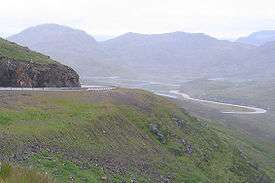
European route E 69 is an E-road between Olderfjord and North Cape in northern Norway. The road is 129 km (80 mi) long. It contains five tunnels, totalling 15.5 km (9.6 mi). The longest, the North Cape Tunnel, is 6.9 km (4.3 mi) long and reaches 212 m (696 ft) below sea level.
The northernmost part of the road is during the winter months available only through convoy driving at fixed times.
E 69 is the northernmost road in the world with connections to a major international road network. Roads further north in e.g. Svalbard and Greenland are isolated and short.
History
In the first version of the current E-road network established in 1975, E69 was a longer and completely different road from Warsaw to Wiener Neustadt through Piotrków, Katowice, Český Těšín, Žilina, Trenčín, Piešťany and Bratislava. This is now mostly part of E75, and that time, the E75 went through Kraków and Banská Bystrica, which is now part of E77.[1] It was later modified south from Mattersburg. Instead of Wiener Neustadt, it went further to south touching Oberpullendorf and Oberwart following the Austrian route 50, ending in E66.[2] This version was never signposted along roads, instead a modified version was implemented with E75 on this route. In the old version E-road network established in 1950, E69 went between Ålesund and Dombås in Norway, now E136.[3]
The E69 got its current route number in 1992. Before that, the road was number 95 in Norway. Since then, it has no distinct national number. From 1999 to 29 June 2012, the North Cape Tunnel and adjacent tunnels were tolled.[4] Before the North Cape Tunnel and the Honningsvåg Tunnel were opened in 1999, there was a 15 kilometres (9.3 mi; 8.1 nmi) long ferry line between Kåfjord and Honningsvåg.
The Skarvberg tunnel from 1968 near the southern end of E69 is an obstacle. It is partly only 4.7 metres (15 ft) wide, so wide vehicles can't meet anywhere, and there is rockslide danger in the area. Therefore a new tunnel will be built 2018-2021 which also will shorten the route by 2 km.
References
- ↑ "volume-1302-l-21618-English.pdf" (pdf). Retrieved 2017-06-08.
- ↑ ATLASZ PLUSZ MAGYARORSZÁG+BUDAPEST+210 település részletes térképe (in Hungarian). Z-Press Kiadó Kft.
- ↑ Declaration on the construction of main international traffic arteries. 1950 - 1961
- ↑ "Slutt på bompengene | Statens Vegvesen" (in Norwegian). Retrieved 2016-06-08.
| Wikimedia Commons has media related to E 69. |
Coordinates: 71°10′04″N 25°46′54″E / 71.16778°N 25.78167°E