Natuna Regency
| Natuna Regency Kabupaten Natuna | ||
|---|---|---|
| Islands and Regency | ||
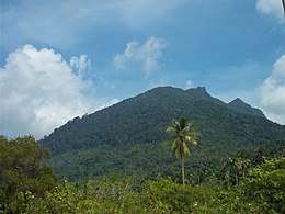 Mount Ranai in Natuna Regency | ||
| ||
| Motto(s): Malay: Laut Sakti Rantau Bertuah | ||
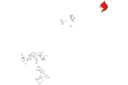 Location within Riau Islands | ||
 Natuna Regency  Natuna Regency Natuna Regency (Sumatra)  Natuna Regency Natuna Regency (Indonesia) | ||
| Coordinates: 4°00′N 108°15′E / 4.000°N 108.250°ECoordinates: 4°00′N 108°15′E / 4.000°N 108.250°E | ||
| Country |
| |
| Region | Sumatra | |
| Province |
| |
| Capital | Ranai | |
| Government | ||
| • Regent | Abdul Hamid Rizal | |
| • Vice Regent | Ngesti Yuni Suprapti | |
| Area | ||
| • Total | 2,008.8 km2 (775.6 sq mi) | |
| Population (2017) | ||
| • Total | 75,282 | |
| • Density | 37/km2 (97/sq mi) | |
| Time zone | UTC+7 (Indonesia Western Time) | |
| Postcodes | 297xx | |
| Area code | (+62) 773 | |
| Website |
natunakab | |

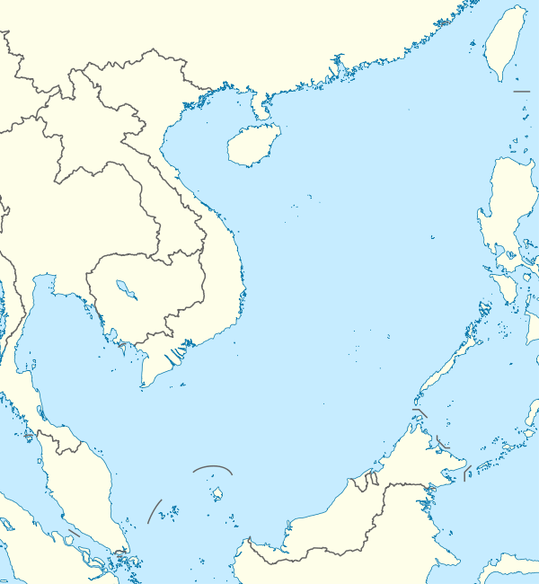
The Natuna Regency is an archipelago of 272 islands located in the south part of the South China Sea in the Natuna Sea. It is part of the larger Tudjuh Archipelago, off the northwest coast of Borneo. Administratively, the islands (including the central Bunguran Islands and various outliers) constitute a regency within the Riau Islands Province of Indonesia and are the northernmost non-disputed island group of Indonesia.
Indonesia's exclusive economic zone (EEZ) off the coast of Natuna slightly overlaps the area within China's South China Sea claim indicated by the so-called "Nine-Dash Line". In 2014–2015, the presence of the Indonesian army on the islands was reinforced, which the Indonesian government hoped would reduce the chance of any conflict.[1]
The Natuna Islands themselves are divided into three groups:
- North Natuna, which includes Laut Island (Pulau Laut);
- Middle Natuna, which includes Bunguran (Natuna Besar); and
- South Natuna, which includes the Subi Islands and Serasan.
Administration
The Regency is divided into twelve districts (kecamatan) – tabulated below from north to south with their 2010 Census population:[2]
| Name | English name | Area in sq.km | Population (2010 Census)[2] |
|---|---|---|---|
| Pulau Laut | (North Island) | 37.5 | 2,169 |
| Bunguran Utara | (North Bunguran) | 402.6 | 3,817 |
| Bunguran Timur Laut | (Northeast Bunguran) | 233.9 | 4,306 |
| Bunguran Tengah | (Central Bunguran) | 171.9 | 2,834 |
| Bunguran Timur | (East Bunguran) | 145.8 | 22,800 |
| Bunguran Barat | (West Bunguran) | 444.8 | 10,893 |
| Bunguran Selatan | (South Bunguran) | 232.1 | 2,537 |
| Pulau Tiga | (Bodas Islands) | 67.5 | 4,826 |
| Midai | (Midai Island) | 26.9 | 5,007 |
| Subi | (Subi Islands) | 155.8 | 2,577 |
| Serasan | 45.9 | 4,506 | |
| Serasan Timur | (East Serasan) | 45.9 | 2,731 |
Demographics
Peoples
According to statistics released in 2010, the population of the islands stood at 69,003 people. 85.27% of the inhabitants were Malays, with the remainder consisting of Javanese, Sumatrans and Chinese. By January 2014, the population was officially estimated to be 83,498.
Islam is the predominant religion of the islands.[3]
Religion
Islam is the dominant religion in the city, with 96.97% of the total population identify themselves as Muslim. Other religions are Christianity, which forms 1.66% of the total population, Buddhism, which forms 1.23% of the total population, and Confucianism, which forms 0.14% of the total population.
Economy
Despite important natural gas reserves, most of the locals work as fishermen or farmers. There is no significant tourism industry. Farming is not on an industrial scale, just small holdings. The other main source of income is gained by people working for the government.
Geography
.jpg)
The Natuna Islands are a 272-island archipelago of Indonesia, located in the Natuna Sea[5][6] between Peninsular Malaysia to the west and Borneo to the east. They extend in a NNW direction for 300 km from Tanjung Api, the northwest extremity of Kalimantan/Borneo. The Natuna Sea itself is a section of the South China Sea.
The North Group consists of a large island (Pulau Laut), two small islands and several adjacent islets and reefs which lie about 50 km NNW of Natuna Besar Island. Pulau Laut is about 11 km long with a greatest width of 5 km towards the south; it is generally hilly, rising to 273 metres near its north end.
The Middle Group consists of Natuna Besar or Bunguran Island, which contains the bulk of the area and population of the archipelago, together with small offshore islets and reefs; the Bodas Islands (Kepulauan Bodas) are a group of moderately high wooded islands lying close to the southwest coast of Natuna Besar.
The Southern Group (Kepulauan Natuna Selatan) consists primarily of two groups of islands separated from the coast of Kalimantan by the Api Passage. The Subi Islands (Kepulauan Subi) of which the main islands are Subi Besar, Subi Kecil, Bakau, Panjang and Seraya, lie southeast of Natuna Besar. Serasan Island (Pulau Serasan) is the largest of the islands lying further to the southeast and nearer to Kalimantan.
Natural resources
Natuna has large reserves of natural gas (estimated to 1.3 billion m3) that is exported to neighbouring countries such as Singapore. Matak Island now serves as an offshore exploitation base.
Ecology
The Natuna Islands have a remarkable avifauna with 71 species of bird registered, including the near-threatened lesser fish-eagle, the Natuna serpent-eagle. Other endangered species include the green iora, the brown fulvetta or the green broadbill.
Colourful coral reefs are found in the neighbouring waters. The Natuna banded leaf monkey, Presbytis natunae, is among[7] the 25 most endangered primates on Earth.
See also
References
- ↑ The sleepy island Indonesia is guarding from China, BBC News, Karishma Vaswani, 19 October 2014
- 1 2 Biro Pusat Statistik, Jakarta, 2011.
- ↑ The Natuna Islands: Geographically Malaysian, politically Indonesian, mstar.com.my. 7 December 2013 (in Malay)
- ↑ "Riau Islands Province in Figures 2017". BPS Kepulauan Riau. Retrieved July 22, 2018.
- ↑ "Natuna Islands: Indonesia says no 'overlapping' South China Sea claims with China". ABC News.
- ↑ "South China Sea: Indonesia renames part of maritime economic zone in defiance of Beijing". ABC News.
- ↑ Martjan Lammertink, Vincent Nijman and Utami Setiorini, "Population size, Red List status and conservation of the Natuna leaf monkey Presbytis natunae endemic to the island of Bunguran, Indonesia." Oryx / Volume 37 / Issue 04 / October 2003, pp 472 – 479
Further reading
- National Geospatial Intelligence Agency (2005) "Borneo: Northwest Coast and Kepulauan Tudjuh" Sailing directions (enroute): Borneo, Jawa, Sulawesi, and Nusa Tenggara United States National Geospatial-Intelligence Agency
- The Natuna Islands: Geographically Malaysian, politically Indonesian (In English)
External links
| Wikimedia Commons has media related to Natuna Regency. |
Main islands of Riau Islands Province | ||
|---|---|---|
| Riau Archipelago |
| |
| Natuna Islands |
| |
| Anambas Islands |
| |
| Lingga Islands | ||
Regencies and cities of Riau Islands Province | ||
|---|---|---|
Capital: Tanjung Pinang | ||
| Regencies | ||
| Cities | ||
| Pratas Islands | |||||||||||||||||
|---|---|---|---|---|---|---|---|---|---|---|---|---|---|---|---|---|---|
| Paracel Islands |
| ||||||||||||||||
| NorthEast SCS | |||||||||||||||||
| Spratly Islands |
| ||||||||||||||||
| Southern SCS | |||||||||||||||||
| Tudjuh Archipelago | |||||||||||||||||
| History | |||||||||||||||||
| Transport |
| ||||||||||||||||
| |||||||||||||||||
| Authority control |
|---|