| [4] |
Name on the Register[5] |
Image |
Date listed[6] |
Location |
City or town |
Description |
|---|
| 1 |
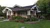
James Alvis House |
|
May 23, 1980
(#80001335) |
1311 Pole Line Rd.
42°35′32″N 114°27′20″W / 42.592222°N 114.455556°W / 42.592222; -114.455556 (James Alvis House) |
Twin Falls |
|
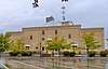
| 2 |
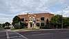
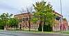
Bickel School |
|
August 17, 1990
(#90001233) |
607 2nd Ave., E.
42°33′08″N 114°27′41″W / 42.552222°N 114.461389°W / 42.552222; -114.461389 (Bickel School) |
Twin Falls |
|
| 3 |
T. P. Bowlby Barn |
|
September 7, 1983
(#83000293) |
Northeast of Buhl
42°37′23″N 114°42′17″W / 42.623056°N 114.704722°W / 42.623056; -114.704722 (T. P. Bowlby Barn) |
Buhl |
|
| 4 |
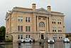
Buhl City Hall |
|
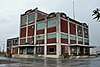
February 8, 1978
(#78001099) |
Broadway and Elm St.
42°36′00″N 114°45′38″W / 42.6°N 114.760556°W / 42.6; -114.760556 (Buhl City Hall) |
Buhl |
|
| 5 |
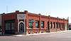
Buhl IOOF Building |
|
December 27, 1984
(#84000482) |
1014-16 Main St.
42°35′56″N 114°45′35″W / 42.598889°N 114.759722°W / 42.598889; -114.759722 (Buhl IOOF Building) |
Buhl |
|
| 6 |
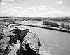
Caldron Linn |
|
June 27, 1972
(#72000442) |
2 miles east of Murtaugh
42°29′53″N 114°09′46″W / 42.498056°N 114.162778°W / 42.498056; -114.162778 (Caldron Linn) |
Murtaugh |
Extends into Jerome County |
| 7 |
Cedar Draw School |
|
August 8, 1991
(#91000986) |
4300 N. Rd. between 1900 and 2000 E.
42°37′20″N 114°40′03″W / 42.622222°N 114.6675°W / 42.622222; -114.6675 (Cedar Draw School) |
Buhl |
|
| 8 |
Dau-Webbenhorst Barn |
|
September 7, 1983
(#83000295) |
Southeast of Buhl
42°34′40″N 114°44′22″W / 42.577778°N 114.739444°W / 42.577778; -114.739444 (Dau-Webbenhorst Barn) |
Buhl |
|
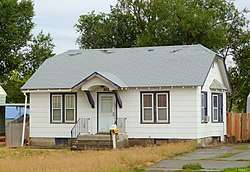
| 9 |
Achille Duquesne House |
|
September 23, 1993
(#93000990) |
710 W. Midway
42°34′17″N 114°36′49″W / 42.571389°N 114.613611°W / 42.571389; -114.613611 (Achille Duquesne House) |
Filer |
|
| 10 |
Hollister School |
|
August 8, 1991
(#91000984) |
2464 Salmon Ave.
42°21′24″N 114°35′31″W / 42.356667°N 114.591944°W / 42.356667; -114.591944 (Hollister School) |
Hollister |
|
| 11 |
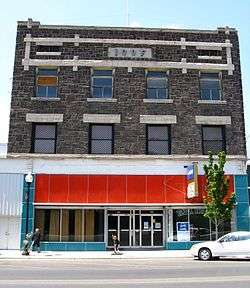
Hotel Buhl |
|
September 12, 1985
(#85002158) |
1004 Main St.
42°35′56″N 114°45′35″W / 42.598889°N 114.759722°W / 42.598889; -114.759722 (Hotel Buhl) |
Buhl |
|
| 12 |
Idaho Power Substation |
|
June 23, 1978
(#78001100) |
Van Buren St. and Filer Ave.
42°34′14″N 114°28′12″W / 42.570556°N 114.47°W / 42.570556; -114.47 (Idaho Power Substation) |
Twin Falls |
|
| 13 |
Kimberly High School |
|
August 17, 1990
(#90001229) |
141 Center St., W.
42°32′00″N 114°21′55″W / 42.533333°N 114.365278°W / 42.533333; -114.365278 (Kimberly High School) |
Kimberly |
|
| 14 |
Rudolf Kunze Barn |
|
April 5, 1994
(#83000292) |
Northeast of Buhl
42°35′05″N 114°42′42″W / 42.584722°N 114.711667°W / 42.584722; -114.711667 (Rudolf Kunze Barn) |
Buhl |
|
| 15 |
Lincoln School |
|
August 17, 1990
(#90001218) |
238 7th St., N.
42°33′43″N 114°28′33″W / 42.561875°N 114.475800°W / 42.561875; -114.475800 (Lincoln School) |
Twin Falls |
|
| 16 |
Lincoln Street Electric Streetlights |
|
April 27, 1992
(#92000413) |
105, 120, 147, 174, 189, 210, 217, 242, 275, and 290 Lincoln St.
42°33′51″N 114°27′38″W / 42.564167°N 114.460556°W / 42.564167; -114.460556 (Lincoln Street Electric Streetlights) |
Twin Falls |
|
| 17 |
Art and Frieda Maxwell Barn |
|
September 7, 1983
(#83000291) |
Southeast of Buhl
42°35′25″N 114°42′36″W / 42.590278°N 114.71°W / 42.590278; -114.71 (Art and Frieda Maxwell Barn) |
Buhl |
|
| 18 |
Robert McCollum House |
|
November 4, 1982
(#82000386) |
708 E. Shoshone St.
42°33′36″N 114°27′48″W / 42.56°N 114.463333°W / 42.56; -114.463333 (Robert McCollum House) |
Twin Falls |
|
| 19 |
Milner Dam and the Twin Falls Main Canal |
|
July 10, 1986
(#86001720) |
Twin Falls Main Canal between Murtaugh and Milner Lakes
42°29′58″N 114°04′50″W / 42.499444°N 114.080556°W / 42.499444; -114.080556 (Milner Dam and the Twin Falls Main Canal) |
Murtaugh |
Extends into Jerome County |
| 20 |
Burton Morse House |
|
September 23, 1993
(#93000992) |
136 10th Ave., N.
42°33′45″N 114°27′41″W / 42.5625°N 114.461389°W / 42.5625; -114.461389 (Burton Morse House) |
Twin Falls |
|
| 21 |
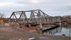
Owsley Bridge |
|
September 18, 1998
(#98001172) |
Approximately 200 yards north of the junction of old U.S. Route 30 and Bell Rapids Rd.
42°45′52″N 114°53′21″W / 42.764444°N 114.889167°W / 42.764444; -114.889167 (Owsley Bridge) |
Hagerman |
Extends into Gooding County |
| 22 |
D. H. Peck House |
|
September 23, 1993
(#93000993) |
207 E. 8th Ave.
42°33′35″N 114°27′40″W / 42.559722°N 114.461111°W / 42.559722; -114.461111 (D. H. Peck House) |
Twin Falls |
|
| 23 |
Pleasant Valley School |
|
August 8, 1991
(#91000985) |
3501 E. 3100 N.
42°26′48″N 114°21′45″W / 42.446667°N 114.3625°W / 42.446667; -114.3625 (Pleasant Valley School) |
Kimberly |
|
| 24 |
Pleasant View School |
|
August 8, 1991
(#91000987) |
2500 E. 3600 N.
42°31′12″N 114°33′30″W / 42.52°N 114.558333°W / 42.52; -114.558333 (Pleasant View School) |
Twin Falls |
|
| 25 |
Walter Priebe House |
|
September 23, 1993
(#93000991) |
155 7th Ave. E.
42°33′34″N 114°27′44″W / 42.559444°N 114.462222°W / 42.559444; -114.462222 (Walter Priebe House) |
Twin Falls |
|
| 26 |
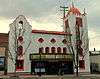
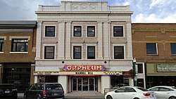
Ramona Theater |
|
December 22, 1976
(#76000682) |
113 Broadway
42°35′55″N 114°45′31″W / 42.598611°N 114.758611°W / 42.598611; -114.758611 (Ramona Theater) |
Buhl |
|
| 27 |
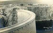
Salmon Falls Dam |
|
May 15, 2009
(#09000328) |
Three Creek Highway
42°12′44″N 114°44′03″W / 42.212131°N 114.734208°W / 42.212131; -114.734208 (Salmon Falls Dam) |
Rogerson |
|
| 28 |
Henry Schick Barn |
|
September 7, 1983
(#83000290) |
Southeast of Buhl
42°34′46″N 114°42′42″W / 42.579444°N 114.711667°W / 42.579444; -114.711667 (Henry Schick Barn) |
Buhl |
|
| 29 |
C. Harvey Smith House |
|
April 3, 1978
(#78001101) |
255 4th Ave., E.
42°33′23″N 114°27′51″W / 42.556389°N 114.464167°W / 42.556389; -114.464167 (C. Harvey Smith House) |
Twin Falls |
|
| 30 |
Stricker Store and Farm |
|
August 30, 1979
(#79000810) |
North of Rock Creek
42°27′33″N 114°19′16″W / 42.459167°N 114.321111°W / 42.459167; -114.321111 (Stricker Store and Farm) |
Twin Falls |
|
| 31 |
Toana Freight Wagon Road Historic District |
|
November 29, 2006
(#06001075) |
Generally runs south to north from Nevada-Idaho state line to the Snake River
42°21′40″N 114°52′04″W / 42.361111°N 114.867778°W / 42.361111; -114.867778 (Toana Freight Wagon Road Historic District) |
Castleford |
|
| 32 |
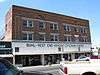
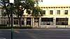
Twin Falls Bank and Trust Company Building |
|
September 4, 1986
(#86002155) |
102 Main Ave. S
42°33′20″N 114°28′08″W / 42.555556°N 114.468889°W / 42.555556; -114.468889 (Twin Falls Bank and Trust Company Building) |
Twin Falls |
|
| 33 |
Twin Falls Canal Company Building |
|
August 30, 1996
(#96000944) |
162 2nd St., W.
42°33′21″N 114°28′17″W / 42.555833°N 114.471389°W / 42.555833; -114.471389 (Twin Falls Canal Company Building) |
Twin Falls |
|
| 34 |
Twin Falls City Park Historic District |
|
March 30, 1978
(#78001102) |
2nd N., 2nd E., and Shoshone Sts., 4th and 6th Aves.
42°33′31″N 114°27′57″W / 42.558611°N 114.465833°W / 42.558611; -114.465833 (Twin Falls City Park Historic District) |
Twin Falls |
|
| 35 |
Twin Falls Downtown Historic District |
|
February 4, 2000
(#00000035) |
Roughly bounded by 2nd Ave., N., 2nd St., E., 2nd St., W., 2nd St., S., 3rd Ave., S., and 3rd St., W.
42°33′23″N 114°28′14″W / 42.556389°N 114.470556°W / 42.556389; -114.470556 (Twin Falls Downtown Historic District) |
Twin Falls |
|
| 36 |
Twin Falls Milling and Elevator Company Warehouse |
|
August 31, 1995
(#95001059) |
516 2nd St., S.
42°33′08″N 114°28′23″W / 42.552099°N 114.472923°W / 42.552099; -114.472923 (Twin Falls Milling and Elevator Company Warehouse) |
Twin Falls |
|
| 37 |
Twin Falls Original Townsite Residential Historic District |
|
November 30, 2001
(#01001306) |
Roughly bounded by Blue Lakes Ave., Addison Ave., 2nd Ave. E, and 2nd Ave. W
42°33′36″N 114°28′12″W / 42.560006°N 114.470029°W / 42.560006; -114.470029 (Twin Falls Original Townsite Residential Historic District) |
Twin Falls |
|
| 38 |
Twin Falls Warehouse Historic District |
|
January 15, 1997
(#96001592) |
Roughly bounded by 2nd Ave., 4th St., S. and W., and Minidoka Ave.
42°33′10″N 114°28′23″W / 42.552671°N 114.473106°W / 42.552671; -114.473106 (Twin Falls Warehouse Historic District) |
Twin Falls |
|
| 39 |
Union School |
|
March 20, 2003
(#03000123) |
21337 U.S. Route 30
42°33′49″N 114°32′56″W / 42.563611°N 114.548889°W / 42.563611; -114.548889 (Union School) |
Filer |
|
| 40 |
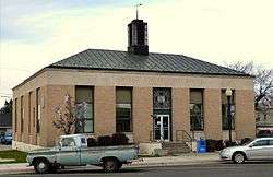
US Post Office-Buhl Main |
|
March 16, 1989
(#89000130) |
830 Main
42°36′00″N 114°45′28″W / 42.6°N 114.757778°W / 42.6; -114.757778 (US Post Office-Buhl Main) |
Buhl |
|