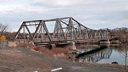
Owsley Bridge
|
Owsley Bridge | |
 | |
 | |
| Nearest city | Hagerman, Idaho |
|---|---|
| Coordinates | 42°45′52″N 114°53′21″W / 42.764444°N 114.889167°WCoordinates: 42°45′52″N 114°53′21″W / 42.764444°N 114.889167°W |
| Area | less than one acre |
| Built | 1920-21 |
| Engineer | Kyle, Charles A. |
| Architectural style | Cantilevered Warren truss |
| NRHP reference # | 98001172[1] |
| Added to NRHP | September 18, 1998 |
Owsley Bridge, about 3.6 miles (5.8 km) south Hagerman, Idaho, is a historic bridge spanning the Snake River between Gooding County and Twin Falls County, Idaho. It is a cantilevered Warren truss bridge built in 1920-21.[2] It was listed on the National Register of Historic Places in 1998.[1]
The bridge cost about $127,000. The engineer for the state of Idaho was Charles A. Kyle of the Bureau of Highways, Division of Public Works. The builder was United States Bridge Company of Boise, Idaho; the fabricator was the Minneapolis Steel & Machinery Company.[2]
It is located approximately 200 yards north of the junction of old U.S. Route 30 and Bell Rapids Rd.[2]
References
- 1 2 National Park Service (2013-11-02). "National Register Information System". National Register of Historic Places. National Park Service.
- 1 2 3 Donald W. Watts (February 20, 1998). "National Register of Historic Places Registration: Owsley Bridge / IHSI 47-5153". National Park Service. Retrieved May 29, 2018. With accompanying six photos from 1998
External links

| Topics | |
|---|---|
| Lists by states |
|
| Lists by insular areas | |
| Lists by associated states | |
| Other areas | |
| |
This article is issued from
Wikipedia.
The text is licensed under Creative Commons - Attribution - Sharealike.
Additional terms may apply for the media files.