Twin Falls Original Townsite Residential Historic District
|
Twin Falls Original Townsite Residential Historic District | |
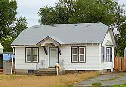 The house at 612 4th Avenue North in 2016 | |
| Location | Roughly bounded by Blue Lakes Ave., Addison Ave., 2nd Ave. E, and 2nd Ave. W, Twin Falls, Idaho |
|---|---|
| Coordinates | 42°33′36″N 114°28′12″W / 42.560006°N 114.470029°WCoordinates: 42°33′36″N 114°28′12″W / 42.560006°N 114.470029°W |
| Area | 264 acres (1.07 km2) |
| Built by | Morse, Burton; Smith, C. Harvey, et al |
| Architectural style | multiple |
| NRHP reference # | 01001306[1] |
| Added to NRHP | November 30, 2001 |
The Twin Falls Original Townsite Residential Historic District in Twin Falls, Idaho is a 264 acres (1.07 km2) historic district which was listed on the National Register of Historic Places in 2001.[1]
The district is roughly triangular, and roughly bounded by Blue Lakes Ave., Addison Ave., 2nd Ave. E, and 2nd Ave. W. It included 929 buildings, of which 624 were contributing buildings.[2]
The district includes the Bickel School and the Lincoln School, both of which are listed separately on the National Register.[2]
References
- 1 2 National Park Service (2010-07-09). "National Register Information System". National Register of Historic Places. National Park Service.
- 1 2 Elizabeth Egleston Giraud (2001). "National Register of Historic Places registration: Twin Falls Original Townsite Residential Historic District". National Park Service. Retrieved October 14, 2017. With 51 photos.
| Topics | |
|---|---|
| Lists by states |
|
| Lists by insular areas | |
| Lists by associated states | |
| Other areas | |
| |
This article is issued from
Wikipedia.
The text is licensed under Creative Commons - Attribution - Sharealike.
Additional terms may apply for the media files.