Tittabawassee River
| Tittabawassee River | |
|---|---|
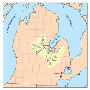 Saginaw River watershed | |
| Physical characteristics | |
| Main source |
Edwards Township, Ogemaw County, Michigan 44°05′27″N 84°18′49″W / 44.09085°N 84.31361°W[1] |
| River mouth |
Saginaw River, Michigan 43°23′12″N 83°57′58″W / 43.38669°N 83.96608°WCoordinates: 43°23′12″N 83°57′58″W / 43.38669°N 83.96608°W |
| Length | 72 mi (116 km) |
| Basin features | |
| Basin size | 2,471 sq mi (6,400 km2) |
The Tittabawassee River is a stream that flows in a generally southeasterly direction through the Lower Peninsula of the U.S. state of Michigan. The river begins at Secord Lake in Clement Township, at the confluence of the East Branch and the Middle Branch.[2] From there it flows through Gladwin, Midland and Saginaw counties where, as a major tributary of the Saginaw River, it flows into it at Saginaw. Its tributaries include the Chippewa, Pine, Molasses, Sugar, and Tobacco rivers.
Significant communities on or near the Tittabawassee River include Saginaw, Midland, and Sanford. At Edenville, the river is impounded by the hydroelectric Edenville Dam to create Wixom Lake. In Saginaw County, the river flows through Tittabawassee Township, which is named for the river and contains the unincorporated community of Freeland.
The main river is 72.4 miles (116.5 km) long[2] and drains an area of 2,471 square miles (6,400 km2).[3]
See also
External links
References
- ↑ "Tittabawassee River". Geographic Names Information System. United States Geological Survey.
- 1 2 U.S. Geological Survey. National Hydrography Dataset high-resolution flowline data. The National Map, accessed November 7, 2011
- ↑ Tittabawassee River Assessment Michigan Department of Natural Resources
Central/Mid-Michigan including the Tri-Cities and Thumb | |||||||
|---|---|---|---|---|---|---|---|
| Central cities | |||||||
| Counties |
| ||||||
| Geography | |||||||
| Transportation | |||||||
| Economy | |||||||
| Authority control |
|---|