Perris, California
| Perris | ||
|---|---|---|
| City | ||
| City of Perris | ||
 Perris railway station | ||
| ||
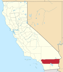
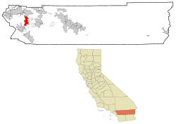 Location in Riverside County and the state of California | ||
 Perris Location in the United States  Perris Perris (the US) | ||
| Coordinates: 33°47′48″N 117°13′28″W / 33.79667°N 117.22444°WCoordinates: 33°47′48″N 117°13′28″W / 33.79667°N 117.22444°W | ||
| Country |
| |
| State |
| |
| County | Riverside | |
| Incorporated | May 26, 1911[1] | |
| Government | ||
| • Type | Council-manager | |
| • Mayor City Council |
Michael M. Vargas[2] David Starr RabbRita Rogers Tonya Burke Malcolm Corona | |
| Area[3] | ||
| • Total | 31.67 sq mi (82.03 km2) | |
| • Land | 31.56 sq mi (81.74 km2) | |
| • Water | 0.11 sq mi (0.28 km2) 0.35% | |
| Elevation[4] | 1,453 ft (443 m) | |
| Population (2010)[5] | ||
| • Total | 68,386 | |
| • Estimate (2017)[6] | 77,879 | |
| • Density | 2,418.52/sq mi (933.80/km2) | |
| Time zone | UTC−8 (Pacific) | |
| • Summer (DST) | UTC−7 (PDT) | |
| ZIP Codes | 92570–92572, 92599 | |
| Area code | 951 | |
| FIPS code | 06-56700 | |
| GNIS feature IDs | 1652772, 2411403 | |
| Website |
www | |

Perris is a city in Riverside County, California, United States, located 17.6 miles (28.3 km) south of Riverside, California, 80.9 miles (130.2 km) north of San Diego, California, and 93.4 miles (150.3 km) north of the Mexican border. At the 2010 census, the city population was 68,386, up from 36,189 at the 2000 census. Perris is within the Inland Empire metropolitan area of Southern California.
History
The Perris Valley was actively settled in the 1880s, a boom period for Southern California. Prior to 1880, the land was used for pastures. The coming of the California Southern Railroad led to the founding of the city around the new depot. The California Southern was built through the future town site in 1882 to open a rail connection between the present day cities of Barstow and San Diego. Due to a land title dispute at Pinacate, most of its citizens moved two miles north on the railroad and established Perris in 1885. The city is named in honor of Fred T. Perris, chief engineer of the California Southern Railroad. The city of Perris was incorporated in 1911. It originally was part of San Diego County, but in 1892 was transferred to the newly established Riverside County.[7]
Perris now incorporates Pinacate Station which is the home of the Orange Empire Railway Museum (a.k.a. "the trolley museum") - the largest operating museum of its kind on the West Coast of the United States.
On March 20, 2007, Perris was featured on ABC's Nightline news show during its "Realty Check" segment. The story dealt with the rising trend of home foreclosures in Riverside County, and Perris was referred to as the "epicenter".
The Farmer Boys restaurant chain, which has many locations throughout the Inland Empire, was started in Perris in 1981.
Perris is also known for the Rock Castle house set on a hill above town.
Geography
According to the United States Census Bureau, the city has a total area of 31.5 square miles (82 km2), of which, 31.4 square miles (81 km2) of it is land and 0.1 square miles (0.26 km2) of it (0.35%) is water.
Climate
Perris has a Mediterranean climate, with warm to hot summers and cool winters. In the summer, highs average in the mid to high 90s, and during the winter, the lows can get as cold as 25, with averages in the mid to upper 30s.
The climate in this area is described by the Köppen Climate Classification System as "dry-summer subtropical" often referred to as "Mediterranean" and abbreviated as Csa.[8]
| Climate data for Perris, California | |||||||||||||
|---|---|---|---|---|---|---|---|---|---|---|---|---|---|
| Month | Jan | Feb | Mar | Apr | May | Jun | Jul | Aug | Sep | Oct | Nov | Dec | Year |
| Average high °C (°F) | 65 (18) |
68 (20) |
68 (20) |
74 (23) |
80 (27) |
85 (29) |
97 (36) |
97 (36) |
91 (33) |
82 (28) |
72 (22) |
64 (18) |
79 (26) |
| Average low °C (°F) | 35 (2) |
37 (3) |
39 (4) |
42 (6) |
47 (8) |
52 (11) |
57 (14) |
59 (15) |
53 (12) |
47 (8) |
40 (4) |
35 (2) |
45 (7) |
| Average precipitation mm (inches) | 1.6 (41) |
1.9 (48) |
1.3 (33) |
1 (30) |
0.2 (5) |
0.1 (3) |
0.3 (8) |
0.1 (3) |
0.4 (10) |
0.1 (3) |
2 (50) |
1.4 (36) |
10.4 (264) |
| Source: Weatherbase [9] | |||||||||||||
Demographics
| Historical population | |||
|---|---|---|---|
| Census | Pop. | %± | |
| 1920 | 499 | — | |
| 1930 | 763 | 52.9% | |
| 1940 | 1,011 | 32.5% | |
| 1950 | 1,807 | 78.7% | |
| 1960 | 2,950 | 63.3% | |
| 1970 | 4,228 | 43.3% | |
| 1980 | 6,827 | 61.5% | |
| 1990 | 21,460 | 214.3% | |
| 2000 | 36,189 | 68.6% | |
| 2010 | 68,386 | 89.0% | |
| Est. 2017 | 77,879 | [6] | 13.9% |
| U.S. Decennial Census[10] | |||
2010
The 2010 United States Census[11] reported that Perris had a population of 68,386. The population density was 2,170.7 people per square mile (838.1/km²). The racial makeup of Perris was 28,937 (42.3%) White (11.0% Non-Hispanic White),[12] 8,307 (12.1%) African American, 589 (0.9%) Native American, 2,461 (3.6%) Asian, 286 (0.4%) Pacific Islander, 24,345 (35.6%) from other races, and 3,461 (5.1%) from two or more races. Hispanic or Latino of any race were 49,079 persons (71.8%).
The Census reported that 68,146 people (99.7% of the population) lived in households, 140 (0.2%) lived in non-institutionalized group quarters, and 100 (0.1%) were institutionalized.
There were 16,365 households, out of which 10,836 (66.2%) had children under the age of 18 living in them, 9,778 (59.7%) were opposite-sex married couples living together, 3,128 (19.1%) had a female householder with no husband present, 1,441 (8.8%) had a male householder with no wife present. There were 1,314 (8.0%) unmarried opposite-sex partnerships, and 120 (0.7%) same-sex married couples or partnerships. 1,442 households (8.8%) were made up of individuals and 383 (2.3%) had someone living alone who was 65 years of age or older. The average household size was 4.16. There were 14,347 families (87.7% of all households); the average family size was 4.32.
The population was spread out with 25,288 people (37.0%) under the age of 18, 7,951 people (11.6%) aged 18 to 24, 20,088 people (29.4%) aged 25 to 44, 11,711 people (17.1%) aged 45 to 64, and 3,348 people (4.9%) who were 65 years of age or older. The median age was 25.9 years. For every 100 females, there were 98.3 males. For every 100 females age 18 and over, there were 93.9 males.
There were 17,906 housing units at an average density of 568.4 per square mile (219.5/km²), of which 10,854 (66.3%) were owner-occupied, and 5,511 (33.7%) were occupied by renters. The homeowner vacancy rate was 5.5%; the rental vacancy rate was 6.8%. 44,695 people (65.4% of the population) lived in owner-occupied housing units and 23,451 people (34.3%) lived in rental housing units.
According to the 2010 United States Census, Perris had a median household income of $46,435, with 28.2% of the population living below the federal poverty line.[12]
2000
At the 2000 census,[13] there were 36,189 people, 9,652 households, and 8,117 families residing in the city. The population density was 1,153.5 per square mile (445.4/km²). There were 10,553 housing units at an average density of 336.4 per square mile (129.9/km²). The racial makeup of the city was predominately Hispanic, with figures as follows: 22% White, 30.9% African American, 1.5% Native American, 2.8% Asian, 0.3% Pacific Islander, 32.6% from other races, and 5.8% from two or more races. Hispanic or Latino of any race were 76.2% of the population.
The median household income was $35,522, and the median family income was $36,063. Males had a median income of $31,891 versus $24,634 for females. The per capita income for the city was $11,425. About 18.1% of families and 20.4% of the population were below the poverty line, including 25.3% of those under age 18 and 14.2% of those age 65 or over.
There were 9,652 households out of which 56.8% had children under the age of 18 living with them, 58.2% were married couples living together, 18.8% had a female householder with no husband present, and 15.9% were non-families. 12.2% of all households were made up of individuals and 4.5% had someone living alone who was 65 years of age or older. The average household size was 3.7 and the average family size was 4.0.
In the city, the population was spread out with 39.6% under the age of 18, 9.9% from 18 to 24, 30.8% from 25 to 44, 13.5% from 45 to 64, and 6.2% who were 65 years of age or older. The median age was 25 years. Perris' large, youthful demographics is a result of families moved into the city's new housing tracts. For every 100 females, there were 96.1 males. For every 100 females age 18 and over, there were 92.2 males.
Diversity
Perris had developed a Latino majority in the 1990s Perris, CA is home to a population of 73,718 people, from which 83.8% are citizens. The ethnic composition of the population of
Perris, CA is composed of 53,903
Hispanic residents (73.1%), 8,175
White residents (11.1%), 7,764
Black residents (10.5%), 2,704
Asian residents (3.67%), and 943
Two+ residents (1.28%).
Government
In the California State Legislature, Perris is in the 31st Senate District, represented by Democrat Richard Roth, and in the 61st Assembly District, represented by Democrat Jose Medina.[14]
In the United States House of Representatives, Perris is in California's 41st congressional district, represented by Democrat Mark Takano.[15]
Economy
Top employers
According to Perris's 2014 Comprehensive Annual Financial Report,[16] the top employers in the city are:
| # | Employer | # of Employees |
|---|---|---|
| 1 | Ross Stores | 1,400 |
| 2 | Starcrest of California | 1,000 |
| 3 | Lowe's | 900 |
| 4 | Perris Union High School District | 786 |
| 5 | Hanesbrands | 650 |
| 6 | Perris Elementary School District | 602 |
| 7 | Eastern Municipal Water District of Southern California | 580 |
| 8 | Whirlpool | 300 |
| 9 | Walmart | 250 |
| 10 | Coreslab Structures | 200 |
Infrastructure
Aviation
The nearby, privately owned, Perris Valley Airport (FAA designator: L65) has a 5,100-foot (1,600 m) runway. Perris has drawn a crowd of skydivers, amateur and professional, to Perris Valley Skydiving. The area's sudden fame gave Perris the nickname: "the skydiving capital of America".. On April 22, 1992, a de Havilland Twin Otter crashed during takeoff at Perris Valley after an engine lost power. The National Transportation Safety Board determined that the accident was caused by contaminated fuel obtained from the improper handling of the airfield’s fuel tanks and the pilot's improper actions after the power loss, as well as other factors. The aircraft never rose above 50 feet and 14 parachutists and the two pilots were killed.[17]
Highways
Perris is served by Interstate 215 which runs from Murrieta to the south to San Bernardino to the north, and by State Route 74, which serves Lake Elsinore and Orange County to the west, and the San Jacinto and Coachella valleys to the east.
Education
The city is served by three school districts: the Perris Elementary School District, Perris Union High School District and the Val Verde Unified School District, which also serves the southern part of Moreno Valley. Perris High School of the Perris district is the city's first public (grades 9–12) school. Established in 1887, the school was relocated in 1961, and the school's western annex on I-215 and Nuevo Road became a Continuation High School in 1993. Now, there are more high schools in the area including Citrus Hill of the Val Verde district.
Middle schools include Pinacate, Lakeside, Perris and Tomas Rivera. There are ten elementary (grades K–6) schools.
Public safety
The Riverside County Sheriff's Department provides police services to the entire Perris Valley area (including the nearby towns/areas of Mead Valley, Quail Valley and Glen Valley, and the Cities of Canyon Lake and newly incorporated Menifee) from its regional station on 4th Street (in the former headquarters of the now-disbanded Perris Police Department).
The city of Perris contracts for fire and paramedic services with the Riverside County Fire Department through a cooperative agreement with CAL FIRE. The CAL FIRE/Riverside County Fire Department headquarters is located in Perris.[18]
The California State Parks have a dispatch center located in the city as well – Southern Communications Center (SURCOM).[19] Communications Centers operate multi-frequency/channel radio systems, law enforcement telecommunications systems (CLETS), computer terminals, and associated equipment to dispatch law enforcement/emergency response units and coordinate services with field personnel and other agencies.
Commuter Rail
In June 2016, the 91 Line of the Metrolink Greater Los Angeles commuter rail system was extended from Riverside to Perris, connecting it to Downtown Los Angeles and the rest of the megalopolis with two stations.[20] Future expansion to Hemet has also been discussed.[21]
Cemetery
The Perris Valley Cemetery District[22] maintains the Perris Valley Cemetery.[23][24]
In film
- The train station scenes in the film Calendar Girl were filmed in Perris. The film starred Jason Priestley, Gabriel Olds and Jerry O'Connell.
- The skydiving scenes in The Bucket List, starring Morgan Freeman and Jack Nicholson, were filmed near Perris.
- Scenes from Eagle Eye starring Billy Bob Thornton and Shia LaBeouf were filmed in Perris.
- Five the Hard Way (also known as Sidehackers) filmed many of its racing scenes in the western hills of Perris. A banner can be seen in the movie with the city's name on it.
- The last scene of the film The Land of the Astronauts[25] (released as Black Limousine in 2010) was shot in Perris. The film stars David Arquette, Bijou Phillips and Vivica A. Fox.
Notable people
- Louis B. Mayer – Hollywood film mogul, owned a horse ranch in Perris
- Alfred E. Green - film director, born in Perris
- Danny Harris – former Olympic hurdler, silver medalist in the 1984 Los Angeles Olympic Games, as well as, the 1987 World Championships in Rome. Grew up in Perris and Alumnus of Perris High School.[26]
Turpin family
In January 2018, authorities discovered 13 malnourished siblings held captive by their own parents, David Allen Turpin, 57, and Louise Anna Turpin, 49, in a home in Perris. Some of the siblings were adults, as old as 29.[27][28][29][30][31]
According to state records, the parents had been operating Sandcastle Day School out of their home.[32]
- The 13 kids house of horror: On Thursday, January 18, 2018, Louise and David Turpin were both formally charged with: 12 counts of torture, 12 counts of false imprisonment, 7 counts of abuse of a dependent adult, and 6 counts of child abuse and neglect. David Turpin faces one charge of a lewd act on a child under 14 by force of fear which prosecutors say was a crime against one of his daughters. If convicted, they face a minimum of 94 years imprisonment each. Bail was set at $13 million, $1 million for each child they are accused of abusing.
See also
References
- ↑ "California Cities by Incorporation Date". California Association of Local Agency Formation Commissions. Archived from the original (Word) on February 21, 2013. Retrieved August 25, 2014.
- ↑ "Council Members". City of Perris. Retrieved February 15, 2017.
- ↑ "2016 U.S. Gazetteer Files". United States Census Bureau. Retrieved June 28, 2017.
- ↑ "Perris". Geographic Names Information System. United States Geological Survey. Retrieved November 2, 2014.
- ↑ "Perris (city) QuickFacts". United States Census Bureau. Archived from the original on April 17, 2015. Retrieved March 20, 2015.
- 1 2 "Population and Housing Unit Estimates". Retrieved October 1, 2018.
- ↑ "Southern Hotel". National Park Service. Retrieved May 5, 2012.
- ↑ "Perris, California Köppen Climate Classification (Weatherbase)". Weatherbase.
- ↑ "Weatherbase.com". Weatherbase. 2013. Retrieved on September 4, 2013.
- ↑ "Census of Population and Housing". Census.gov. Retrieved June 4, 2015.
- ↑ "2010 Census Interactive Population Search: CA - Perris city". U.S. Census Bureau. Retrieved July 12, 2014.
- 1 2 https://web.archive.org/web/20150417222310/http://quickfacts.census.gov/qfd/states/06/0656700.html. Archived from the original on April 17, 2015. Missing or empty
|title=(help) - ↑ "American FactFinder". United States Census Bureau. Retrieved 2008-01-31.
- ↑ "Statewide Database". Regents of the University of California. Retrieved February 22, 2015.
- ↑ "California's 41st Congressional District - Representatives & District Map". Civic Impulse, LLC.
- ↑ "City of Perris CAFR" (PDF).
- ↑ http://www.ntsb.gov/speeches/former/hall/jh970920.htm
- ↑ "Service Area". rvcfire.org.
- ↑ California, California State Parks, State of. "Communications Operator". CA State Parks.
- ↑ "Metrolink's 91/Perris Valley Line Now Open".
- ↑ http://www.cityofhemet.org/DocumentCenter/View/4705
- ↑ brookman@brookmancompany.com. "California Association of Public Cemeteries". capc.info.
- ↑ 33°47′41″N 117°13′25″W / 33.79472°N 117.22361°W U.S. Geological Survey Geographic Names Information System: Perris Valley Cemetery
- ↑ "Perris Valley Cemetery in Perris, California - Find A Grave Cemetery". www.findagrave.com.
- ↑ The Land of the Astronauts on IMDb
- ↑ "IAAF: Men's indoor 60 Metres - Records - iaaf.org". iaaf.org.
- ↑ "In Perris, a house of horrors hidden in plain sight". Los Angeles Times. January 17, 2018.
- ↑ "California torture house: 13 siblings allowed to eat once a day, shower once a year". NBC News. January 18, 2018.
- ↑ "Siblings allegedly held captive were robotic, marched for hours in circles, former neighbor says". ABC News. January 18, 2018. Retrieved January 18, 2018.
- ↑ "Starving California children taunted with pie, beaten by parents: prosecutor". Reuters. January 18, 2018. Retrieved January 18, 2018.
- ↑ "'Haunting and Disturbing.' 13 Siblings Found Shackled Looked Like 'Fun Family' in Facebook Photos". Time Magazine. January 17, 2018. Retrieved January 18, 2018.
- ↑ "California School Directory—Sandcastle Day School".
External links
| Wikimedia Commons has media related to Perris, California. |
- Official website

- Perris Elementary School District website
- Orange Empire Railway Museum
- Riverside County Fire Department Command |
- Howser, Huell (December 9, 2009). "Perris – California's Communities (106)". California's Communities. Chapman University Huell Howser Archive.
Places adjacent to Perris, California | |
|---|---|