National Highway 30 (India)
| ||||
|---|---|---|---|---|
.jpg) | ||||
| Route information | ||||
| Length | 2,022 km (1,256 mi) | |||
| Major junctions | ||||
| From | Sitarganj, Uttarakhand | |||
| To | Ibrahimpatnam, Krishna district, Andhra Pradesh | |||
| Location | ||||
| States |
Andhra Pradesh:80 km Telangana:54 km Chhattisgarh: 174 km | |||
| Primary destinations | Kottagudam – Bhadrachalam – Penta | |||
| Highway system | ||||
| ||||
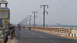
Godavari Bridge at Bhadrachalam on National Highway 30
National Highway 30 (NH 30) (previously National Highway 221) is a National Highway in India. NH 30 connects Sitarganj in Uttarakhand with Ibrahimpatnam in Andhra Pradesh. The total length of this highway is 2040 km (1267.5 mi) It starts at the junction of NH 9 at Sitarganj and ends at the junction of NH 65 at Ibrahimpatnam.[1]
Route
It starts at the junction of Sitarganj, Pilibhit, Bareilly, Shahjahanpur, Sitapur, Lucknow, Raebareli, Allahabad , Rewa, Jabalpur, Mandla, Raipur, Dhamtari, Charama, Kanker, Keskal, Jagdalpur, Sukma, Konta, Nellipaka, Bhadrachalam, Paloncha, Kothagudem and Ibrahimpatnam.[2][1][3]
See also
References
- 1 2 "Rationalization of Numbering Systems of National Highways" (PDF). Department of Road Transport and Highways. p. 30. Retrieved 21 April 2017.
- ↑ "List of National Highways passing through A.P. State". Roads and Buildings Department. Government of Andhra Pradesh. Archived from the original on 28 March 2016. Retrieved 11 February 2016.
- ↑ "Rs. 5,000-cr infrastructure boost for city". The Hindu. 19 June 2016. Retrieved 25 June 2016.

Secondary routes of National Highway 30 | ||
|---|---|---|
 | ||
| Secondary Routes of NH 30 | ||
This article is issued from
Wikipedia.
The text is licensed under Creative Commons - Attribution - Sharealike.
Additional terms may apply for the media files.