Higashimatsushima
| Higashimatsushima 東松島市 | |||
|---|---|---|---|
| City | |||
|
Higashi-Matsushima City Hall | |||
| |||
|
Location of Higashi-Matsushima in Miyagi Prefecture | |||
 Higashimatsushima | |||
| Coordinates: 38°25′34.5″N 141°12′37.5″E / 38.426250°N 141.210417°ECoordinates: 38°25′34.5″N 141°12′37.5″E / 38.426250°N 141.210417°E | |||
| Country | Japan | ||
| Region | Tōhoku | ||
| Prefecture | Miyagi | ||
| Government | |||
| • Mayor | Iwao Atsumi | ||
| Area | |||
| • Total | 101.36 km2 (39.14 sq mi) | ||
| Population (June 2017) | |||
| • Total | 39,481 | ||
| • Density | 390/km2 (1,000/sq mi) | ||
| Time zone | UTC+9 (Japan Standard Time) | ||
| - Tree | Pine | ||
| - Flower | Sakura | ||
| Phone number | 0225-82-1111 | ||
| Address | 36-1 Kamikawado, Yamoto, Higashimatsushima-shi, Miyagi-ken 981-0503 | ||
| Website | Official website (in Japanese) | ||
Higashi-Matsushima (東松島市 Higashimatsushima-shi) is a city located in Miyagi Prefecture, Japan. As of 1 June 2017, the city had an estimated population of 39,481 and a population density of 390 persons per km². The total area of the city is 101.36 square kilometres (39.14 sq mi).
Geography
Higashi-Matsushima (lit. "East Matsushima") is in eastern Miyagi Prefecture in the Tōhoku region of northern Honshu. The city borders on Matsushima Bay to the west, and the Pacific Ocean (Ishinomaki Bay) to the south. Its coastline forms part of the Sanriku Fukkō National Park, which stretches north to Aomori Prefecture.
Neighboring municipalities
- Miyagi Prefecture
Demographics
Per Japanese census data,[1] the population of Higashi-Matsushima has been mostly increasing over the past 40 years.
| Census Year | Population |
|---|---|
| 1970 | 32,192 |
| 1980 | 36,865 |
| 1990 | 40,424 |
| 2000 | 43,180 |
| 2010 | 42,903 |
Climate
Higashi-Matsushima has a humid climate (Köppen climate classification Cfa) characterized by mild summers and cold winters. The average annual temperature in Higashi-Matsushima is 11.7 °C. The average annual rainfall is 1191 mm with September as the wettest month. The temperatures are highest on average in August, at around 24.2 °C, and lowest in January, at around 0.4 °C.[2]
History
The area of present-day Higashi-Matsushima was part of ancient Mutsu Province, and has been settled since at least the Jōmon period by the Emishi people. During the Nara period, the area came under the control of colonists from the Yamato dynasty based at nearby Tagajō. During the Sengoku period, the area was contested by various samurai clans before the area came under the control of the Date clan of Sendai Domain during the Edo period.
The modern city of Higashi-Matsushima was created on April 1, 2005, when the towns of Naruse and Yamoto were merged to create the new city.
2011 Earthquake disaster
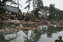
On March 11, 2011, Higashi-Matsushima was severely hit by the 2011 Tōhoku earthquake and tsunami resulting in at least 1,039 deaths,[3] and the destruction of over 11,000 structures, or approximately two-thirds of the buildings in the city limits. During the tsunami, a 45-metre ship, the Chōkai Maru, was hurled over a pier and left aground in the city. At the time of the disaster, Higashi-Matsushima had still not fully recovered from a previous major earthquake in 2003.[4][5] About 63% of the town was inundated by the tsunami.[6]
Government
Higashi-Matsushima has a mayor-council form of government with a directly elected mayor and a unicameral city legislature of 18 members.
Economy
Higashi-Matsushima traditionally has been a center for commercial fishing, especially for the cultivation of oysters and on tourism. The Japan Air Self Defense Force’s Matsushima Air Field is located in Higashi-Matsushima.
Education
Higashi-Matsushima has eight public elementary schools and three middle schools operated by the city government, and two public high school operated by the Miyagi Prefectural Board of Education.
Transportation
Railway
- JR East – Senseki Line
- Rikuzen-Ōtsuka - Tōna - Nobiru - Rikuzen-Ono - Kazuma - Yamoto - Higashi-Yamoto - Rikuzen-Akai
Highway
- Sanriku Expressway (Naruse-Okumatsushima, Yamoto, and Ishinomaki interchanges)
- National Route 45
Local attractions
Noted people from Higashi-Matsushima
- Yutaka Abe – actor, movie director
References
- ↑ Higashi-Matsushima population statistics
- ↑ Higashi-Matsushima climate data
- ↑ NOAA Data 2 April 2011
- ↑ Tsunami survivors face monstrous cleanup task, Japan Times, 26 March 2011
- ↑ Gilhooly, Rob, "Tsunami-hit towns face dire future", Japan Times, 1 April 2011, p. 4.
- ↑ NHK, "Tsunami flooded 100 square kilometers of city land", 29 March 2011.
External links
| Wikimedia Commons has media related to Higashimatsushima. |
- Official website (in Japanese)