Nalagarh
| Nalagarh Hindur | |
|---|---|
| city | |
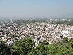 View of city from the Palace/Heritage Resort Nalagarh | |
 Nalagarh Location in Himachal Pradesh, India  Nalagarh Nalagarh (India) | |
| Coordinates: 31°03′N 76°43′E / 31.05°N 76.72°ECoordinates: 31°03′N 76°43′E / 31.05°N 76.72°E | |
| Country |
|
| State | Himachal Pradesh |
| Population (2011) | |
| • Total | 10,708 |
| • Rank | 15 in HP |
| Languages | |
| • Official | Hindi |
| Time zone | UTC+5:30 (IST) |
| Vehicle registration | HP HP-12 |
Nalagarh is a city and a municipal committee in Solan district in the Indian state of Himachal Pradesh. It was the seat of the eponymous Rajput princely state, founded in medieval period as the state of Hindur. At present Nalagarh is an emerging town for industries as it hosts production units for leather, steel, chemicals, thread mills and breweries; thus air pollution is quite a concern here. It is situated at 65 km distance from nearby major city Chandigarh. It has further been reduced to about 40 km after the opening of Chandigarh Siswan road.
History
| Princely state |
|---|
| Individual residencies |
| Agencies |
|
| Lists |
Nalagarh is a gateway to Himachal Pradesh in North India, 300 km of north Delhi and 60 km from Chandigarh. It was founded by the Chandela Rajputs in 1100 AD under the name Hindur. The Fort of Nalagarh, which was built in 1421 during the reign of Raja Bikram Chand on a hillock at the foothills of the mighty Himalayas, affording a panoramic view of the Shivalik hills beyond the Sirsa river, henceforth gave its name to the state, which further enjoyed indirect rule during the British Raj as a non-salute state.
In the early twentieth century, Nalagarh State was one of the Simla hill states, under the government of the Punjab.[1] The country was overrun by the Gurkhas for some years before 1815, when they were driven out by the British, and the raja was confirmed in possession of the territory. Grain and opium have, in the past, been main agricultural products.[2]
Nalagarh was ruled by the Chandela Rajputs, who originated from Chanderi in the Bundelkhand region of central India. Various other Rajputs then inhabited this place including Thakurs, Tomara, Rathore, Parmar, Pawar, Panwar, Chauhan, Bais. Many have now stayed back as farmers in the Chikni Sirsa Valley
Fort Nalagarh surrounded by endless acres of greenery, with all modern amenities is an ideal retreat away from the madding crowd of metropolitan cities.
Ruling Rajas
- ...
- 1618 - 1701 Dharm Chand
- 1701 - 1705 Himmat Chand
- 1705 - 1761? Bhup Singh
- 1761? - 1762 Man Chand (d. c.1762)
- 1762 - 1788 Gaje Singh
- 1788 - 1803 Ram Saran Singh (1st time) (b. c.1762 - d. 1848)
- 1803 - 1815 occupied by Nepal
- 1815 - 1848 Ram Saran Sungh (2nd time) (s.a.)
- 1848 - 1857 Bije Singh (d. 1857)
- 1857 - 15 Jan 1860 interregnum
- 15 Jan 1860 - Dec 1876 Agar Singh (b. 1804 - d. 1876)
- 16 Dec 1876 - 18 Sep 1911 Ishri Singh (b. 1836 - d. 1911)
- 18 Sep 1911 - 1946 Jogindra Singh (b. 1877 - d. 1946)
- 1946 - 15 August 1947 Surendra Singh (b. 1922 - d. 1971)
Palace/Fort
Although a (pre-)colonial feudal princely state, Nalagarh has few historical buildings. It still has a palace/fort which is now converted into the heritage resort. Its building is maintained in original form.Fort Nalagarh surrounded by endless acres of greenery, with all modern amenities is an ideal retreat away from the madding crowd of metropolitan cities.
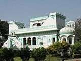 view of palace
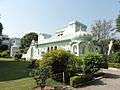 view of palace
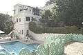 swimming pool of palace
 Architecture of Nalagarh Palace
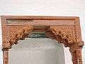 Wooden art work of Nalagarh Palace
Geography
Nalagarh is a Semi Hilly Area. While the summers are hot and dry Winters are Dry and wet. Summers temperature does reach 45 degrees Celsius, also it could be Humid, Which Make "Feel Temperature" at 50 degrees Celsius. During rainy season strong winds are experienced. Yet Nalagarh Physically belongs to Himachal Pradesh but Look and feel of it is mostly like Punjab.More than 80% people are Punjabi. It is a town Which is close to Pinjore in Haryana, to Ropar in Punjab. The average annual rainfall is 600mm. During the year 2007 it has gone up to 1250mm. The soil strata contains mixed layers of clay soil, river pebbles and coarse sand in layers of 2m to 3m.
Demographics
As of 2001 India census,[3] Nalagarh had a population of 9433. Males constitute 54% of the population and females 46%. Nalagarh has an average literacy rate of 76%, higher than the national average of 59.5%: male literacy is 80%, and female literacy is 72%. In Nalagarh, 12% of the population is under 6 years of age. Nalagarh is a municipal council which have 9 wards. Nalagarh area touches the areas of Ropar and Anandpur Sahib of Punjab.
In the 1961 Census of India, 78.4?60.2% of the Nalagarh tehsil of the then Ambala district registered as Hindi-speaking, 14.8% as Punjabi-speakers and 6.4% as Pahari-speaking.
| Rank | Language | 1961 census[4] |
|---|---|---|
| 1 | Hindi | 78.4% |
| 2 | Punjabi | 14.8% |
| 3 | Pahari unspecified | 6.4% |
| 4 | Other | 0.4% |
According to 2011 census the demographic status is as follows:[5].
The Nalagarh (Municipal Council) has population of 10,708 of which 5,739 are males while 4,969 are females.Population of Children with age of 0-6 is 1296 which is 12.10 % of total population of Nalagarh. In Nalagarh Municipal Council, Female Sex Ratio is of 866 against state average of 972. Moreover Child Sex Ratio in Nalagarh is around 914 compared to Himachal Pradesh state average of 909. Literacy rate of Nalagarh city is 90.03 % higher than state average of 82.80 %. In Nalagarh, Male literacy is around 93.07 % while female literacy rate is 86.51 %.
Work profile Out of total population, 4,291 were engaged in work or business activity. Of this 3,309 were males while 982 were females. Of total 4291 working population, 93.08 % were engaged in Main Work while 6.92 % of total workers were engaged in Marginal Work.
Nalagarh Religion profile
| Sr No | Religion | Percentage as per 2011 Census[6] |
|---|---|---|
| 1 | Hindu | 82.01% |
| 2 | Muslim | 10.14% |
| 3 | Christian | 0.31% |
| 4 | Sikh | 4.06% |
| 5 | Buddhist | 0.02% |
| 6 | Jain | 3.36% |
| 7 | Others | 0.01% |
| 8 | Not stated | 0.08% |
Politics
Currently Lakhvinder Singh Rana is the M.L.A.(Congress) of Nalagarh constituency who won by a small margin of 1242 votes defeating B.J.P candidate Er. Krishan Lal Thakur in the assembly elections whose results were declared on 18 December 2017.
Industrialization
Nalagarh is an industrial area with many variety of industries, as nearby grown industry area Baddi is over flowing. Some of the major industries are Samrat Plywood Limited, GPI textiles, Drish, Godrej Hershey Ltd, TVS Motors Sara textiles etc.
Education
Bal Vidya Niketan is oldest school in the region, serving BBN since 1978. Nalagarh has 5 CBSE schools and soon it will also have ICSE school. The school with the highest strength is Alpine Public School, Nalagarh, Himachal Pradesh. Doon valley public school is the 1st CBSE affiliated school in Nalagarh region. Apart from it there are other schools like GuruNanak Public School, Doon Valley Public School, Govt. Senior Secondary School, etc.
References
- ↑ https://books.google.co.in/books?id=ayYbAvECXQwC&pg=PA254&lpg=PA254&dq=The+Princely+House+Of+Nalagarh&source=bl&ots=08cGcBDEzo&sig=EgI0_5A6vzcQaiAUXxSL3ftVw5o&hl=en&sa=X&ved=0ahUKEwjan5yYqPXOAhXCOY8KHZnXBGgQ6AEIHDAA#v=onepage&q=The%20Princely%20House%20Of%20Nalagarh&f=false
- ↑

- ↑ "Census of India 2001: Data from the 2001 Census, including cities, villages and towns (Provisional)". Census Commission of India. Archived from the original on 2004-06-16. Retrieved 2008-11-01.
- ↑ http://14.139.60.114:8080/jspui/bitstream/123456789/955/8/Pathankot%20Tehsil%20(25-46).pdf
- ↑ "Nalagarh Population Census 2011". census2011.co.in. Retrieved 17 September 2018.
- ↑ "Nalagarh Religion data Census 2011". census2011.co.in. Retrieved 17 September 2018.