Mountain Dale, Missouri
| Mountain Dale | |
|---|---|
| Community | |
| Coordinates: 37°11′20″N 92°45′15″W / 37.18889°N 92.75417°WCoordinates: 37°11′20″N 92°45′15″W / 37.18889°N 92.75417°W |
Mountain Dale is an unincorporated community in southeastern Webster County, in the U.S. state of Missouri.[1] The community is located on Missouri Route C about 2.5 miles north of Seymour and just south of the James River headwaters. The Mountain Dale cemetery lies about one quarter mile to the west.[2] Owen Field airstrip and the community of Waldo lies about three-quarters of a mile to the east along Missouri Route V.[3]
The community took its name from a defunct school of the same name which was near a mountain and a dale, hence the name.[4]
References
- ↑ U.S. Geological Survey Geographic Names Information System: Mountain Dale, Missouri
- ↑ Seymour, Missouri 7.5 Minute Topographic Quadrangle, USGS, 1982
- ↑ Missouri Atlas & Gazetteer, DeLorme, 1998, First edition, p. 53, ISBN 0-89933-224-2
- ↑ "Webster County Place Names, 1928–1945". The State Historical Society of Missouri. Archived from the original on June 24, 2016. Retrieved January 2, 2017.
Municipalities and communities of Webster County, Missouri, United States | ||
|---|---|---|
| Cities | 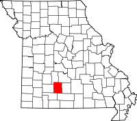 | |
| Village | ||
| Townships |
| |
| Unincorporated communities | ||
| Ghost towns | ||
| Footnotes | ‡This populated place also has portions in an adjacent county or counties | |
This article is issued from
Wikipedia.
The text is licensed under Creative Commons - Attribution - Sharealike.
Additional terms may apply for the media files.