Forkners Hill, Missouri
Forkners Hill is an unincorporated community in northern Webster County, in the Ozarks of southern Missouri.[1] The community is at the intersection of routes WW and Y north of the Niangua River at an elevation of 1250 feet. Conway is four miles to the northeast in Laclede County.[1][2]
History
A post office was in operation at Forkners Hill from 1869 until 1906.[3] The community has the name of the local Forkner family.[4]
References
- 1 2 U.S. Geological Survey Geographic Names Information System: Forkners Hill, Missouri
- ↑ Missouri Atlas & Gazetteer, DeLorme, 1998, First edition, pp. 52-3 ISBN 0-89933-224-2
- ↑ "Webster". Missouri Postal History. Retrieved 1 January 2017.
- ↑ "Webster County Place Names, 1928–1945". The State Historical Society of Missouri. Archived from the original on June 24, 2016. Retrieved January 2, 2017.
Municipalities and communities of Webster County, Missouri, United States | ||
|---|---|---|
| Cities | 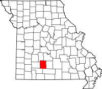 | |
| Village | ||
| Townships |
| |
| Unincorporated communities | ||
| Ghost towns | ||
| Footnotes | ‡This populated place also has portions in an adjacent county or counties | |
Coordinates: 37°28′22″N 92°54′33″W / 37.47278°N 92.90917°W
This article is issued from
Wikipedia.
The text is licensed under Creative Commons - Attribution - Sharealike.
Additional terms may apply for the media files.