Mount Roskill
| Mount Roskill / Mt Roskill | |
|---|---|
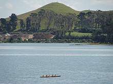
 Mount Roskill from Big King. The Waitakere Ranges in the background. | |
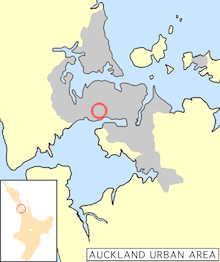 Location of Mount Roskill in Auckland. | |
| Basic information | |
| Local authority | Auckland Council |
| Surrounds | |
| North | Balmoral, Eden Valley |
| Northeast | Mount Eden |
| East | Three Kings |
| Southeast | Hillsborough |
| South | Waikowhai |
| Southwest | Lynfield |
| West | New Windsor, New Zealand, Wesley |
| Northwest | Owairaka, Sandringham |
Mount Roskill is both a volcanic peak and the suburban area in the city of Auckland, New Zealand.
Mountain
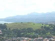
The mountain formed as a result of volcanic activity some 20,000 years ago.[1] Its peak, located in present-day Winstone Park towards the southwest end of the suburb, is 110 metres in height. It is one of the many extinct cones that dot the isthmus of Auckland, all part of the Auckland volcanic field. The scoria cone was built by fire-fountaining from two craters. Lava flowed from the base of the cone to the north and to the northwest.
It was the site of a Māori pā (fortified village), and was known as Puketāpapa ("the flat-topped mountain" in the Māori language) and as Pukewīwī.[2] The main southern crater was excavated in 1961-1962 and filled with a water-supply reservoir. The reservoir is no longer in active service, and is only maintained as an emergency supply.
Since 2009 State Highway 20 has passed close to the cone. The effects of the new motorway on the cone had been the subject of significant discussion, and a major mitigation package had been proposed to reduce the impact of the motorway (and the continuation of the Waikaraka Cycleway that runs parallel to it).[3] The funding of this mitigation and the missing cycleway section was briefly in doubt in 2009, when a cost blowout to $2 million was criticised after Council had set aside $1.6 million. Cycling advocates from Cycle Action Auckland, the Mount Roskill Community Board Chairman Richard Barter and Councillor John Lister however noted various elements unrelated to the cycleway that had driven up the cost, such as a toilet block, bluestone walls, extensive landscaping and artwork, much of it related to Winstone Park itself, or the effects of the motorway. The cycle-path section itself was priced at only $300,000.[4] The path section was finished after six months of construction work and it (and the park facilities) opened to the public on 25 July 2010.[5]
Suburb
The suburb, named after the Mount, is located seven kilometres to the south of the city centre, and is surrounded by the neighbouring suburbs of Three Kings, Sandringham, Wesley, Hillsborough and Mount Albert. The Mount Roskill shops are located at the intersection of Mount Albert and Dominion Roads.
In the 1920s, a new subdivision off Dominion Road was established. It was named the Victory Estate after notable First World War personnel.[6]
One of the city's larger suburbs, it was largely farmland until after the Second World War. It was a separate borough from 1947 until local government reorganisation in 1989 amalgamated it with Auckland City.
In the past, Mount Roskill was referred to as the Bible Belt of Auckland,[7] as it contained the highest number of churches per capita in New Zealand.[8] The electorate was one of the last in the country to go "wet", in 1999, having formally been a dry area where the selling of alcohol was prohibited.[9]
Mount Roskill is one of the most ethnically diverse suburbs in New Zealand with a mix of Indians, Pacific Islanders, Europeans, and various East and South Asian peoples residing in the community and representing at least 54 different nationalities. The area has also begun attracting people of African and Latin American origin.
The local secondary school is Mount Roskill Grammar.
Library
Mt Roskill Library[10] was built and opened to public in August 1977. It was refurbished and the floor area extended in November 2011. Mt Roskill Library has English, Maori, Chinese, Tamil, Arabic and Somali collections.
Sport and recreation
Mount Roskill Rugby Football Club, Bay Roskill Vikings, and Eden Roskill District Cricket Club are based in the suburb.
Dominion Road School
| Dominion Road School | |
|---|---|
| Address | |
|
Quest Terrace, Mt Roskill, Auckland, New Zealand | |
| Coordinates | 36°54′16″S 174°44′36″E / 36.904472°S 174.743460°E |
| Information | |
| Type | State, Co-educational, Primary |
| Motto | Onward and Upward |
| Ministry of Education Institution no. | 1261 |
| Principal | Marian Caulfield |
| School roll | 334[11] (August 2018) |
| Socio-economic decile | 3 |
| Website | dominionrd.school.nz |
Dominion Road School is a decile 3 primary school on Quest Terrace with a roll of 334 students (as of August 2018).[11] The principal is Marian Caulfield, who started in 2001. The school has 20 teaching spaces which are all multipurpose. It is located close to the central city.
People
Mount Roskill has been home to many successful New Zealanders who attended the local schools. Among them are:
- Rugby coach John Hart,
- Billionaire Graeme Hart,
- Rugby union international Doug Howlett,
- Actor and South Sydney Rabbitohs owner Russell Crowe,
- Evangelist Bill Subritzky,
- Reserve Bank Governor Alan Bollard,
- Tennis player Brett Steven,
- Labour MP Phil Goff,
- Balmain Tigers, Eastern Suburbs Roosters, Penrith Panthers and Parramatta Eels and New Zealand rugby league international, 1992 Dally M Medallist, former Kiwi coach and commentator Gary Freeman
- Rugby league (Warriors, Manly, Kiwi) and rugby union (All Blacks) dual international Matthew Ridge
- Rugby league (Bulldogs, Roosters, Kiwi) and rugby union (Crusaders, Chiefs, All Blacks) dual international player Sonny Bill Williams
- Canterbury-Bankstown Bulldogs, South Sydney Rabbitohs and New Zealand Rugby League international, former captain of the latter two- Roy Asotasi
- Former rugby league international Dane O'Hara
- Former rugby league international and New Zealand Maori representative Bill Burgoyne
- Former New Zealand Warriors, Melbourne Storm, St George-Illawarra Dragons, Parramatta Eels and Cronulla-Sutherland Sharks rugby league international, New Zealand Maori representative and current NRL referee Henry Perenara
- Former Parramatta Eels rugby league player Marcus Perenara
- Manly-Warringah Sea Eagles and New Zealand rugby league international Steve Matai
- New Zealand Warriors captain, rugby league international and professional boxer Monty Betham
- Canterbury-Bankstown Bulldogs and Wests Tigers rugby league international Matt Utai
- Sydney Roosters, St. Helens and New Zealand rugby league international Sia Soliola
- New Zealand Warriors and Kiwi rugby league international Evarn Tuimavave
- Parramatta Eels rugby league player Manu Ma'u
- Sydney Roosters rugby league player Adam Henry
- Wests Tigers rugby league player James Gavet
- New Zealand Warriors rugby league player Ben Henry
- Canberra Raiders rugby league player Bill Tupou
- Cronulla-Sutherland Sharks rugby league player Sosaia Feki
- New Zealand Warriors rugby league player Sione Lousi
- New Zealand Warriors rugby league player Sam Lousi
- Newcastle Knights rugby league player Paterika Vaivai
- The Hay family (of Keith Hay Homes)
- Professional cricket player Azhar Abbas
- New York Times Best Selling author Nalini Singh
In 2007, the Mount Roskill Community Board commissioned a 176-page book titled Just Passing Through: A History of Mt Roskill (Jade Reidy) which covered the growth of the district from 1840 up until the present time. It identified the significant input of Mount Roskill residents internationally, such as athletics coach Arthur Lydiard in the chapter "How Sport Put Mt Roskill on the World Map."
References
Coordinates: 36°54′45″S 174°44′14″E / 36.912594°S 174.737259°E
- ↑ Roskill: An Illustrated History of New Zealand's Largest Borough. Mt Roskill Borough Council. 1984. ISBN 0908570848
- ↑ "Alcohol and smoke-free Tāmaki Tūpuna Maunga". Te Kāea. Māori Television. 3 March 2015. Retrieved 29 December 2015.
- ↑ "Motorway fight hits a peak". The New Zealand Herald. 12 March 2003. Retrieved 28 July 2010.
- ↑ Horrell, Rhiannon (6 May 2009). "Cycleway costs soar". Central Leader. Retrieved 26 October 2011.
- ↑ "Scenic cycleway opens". CityScene. Auckland City Council. 25 July 2010.
- ↑ Graves, Joanne. "Mt Roskill's Victory Estate". Heritage et AL. Auckland Libraries.
- ↑ "Mt Roskill". New Zealand Ministry for Culture and Heritage. Retrieved 27 November 2016.
- ↑ "God and money: Interactive map shows rich suburbs have most atheists". New Zealand Herald. 2015-05-13. ISSN 1170-0777. Retrieved 2017-01-15.
- ↑ "Tawa ditches prohibition a century after banning alcohol - 150 years of news". Stuff.co.nz. Retrieved 2017-04-10.
- ↑ "Archived copy". Archived from the original on 28 June 2013. Retrieved 11 April 2013.
- 1 2 "Directory of Schools - as at 13 September 2018". New Zealand Ministry of Education. Retrieved 22 September 2018.
| Wikimedia Commons has media related to Mount Roskill, New Zealand. |
Bibliography
- Nicola Legat:"In God We Trust? The Mount Roskillisation of Auckland" Metro 152 (February 1994): 58-67.
- David Craig: "Thin Topsoil: Queer Blokes, Moral Modernity and Real Estate Politics in New Zealand's Biggest Borough" in Ian Carter, David Craig and Steve Matthewman: Almighty Auckland? Palmerston North: Dunmore Press: 2004: ISBN 0-86469-452-0
- Jade Reidy Just Passing Through: The Making of Mt Roskill (c) 2007 Auckland City Council ISBN 978-1-877362-18-7
- City of Volcanoes: A geology of Auckland - Searle, Ernest J.; revised by Mayhill, R.D.; Longman Paul, 1981. First published 1964. ISBN 0-582-71784-1.
- Volcanoes of Auckland: The Essential Guide. Hayward, B.W., Murdoch, G., Maitland, G.; Auckland University Press, 2011.
External links
- Photographs of Mount Roskill held in Auckland Libraries' heritage collections.