Little Rangitoto
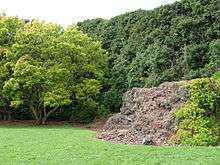
Little Rangitoto (also Maungarahiri) is one of the volcanoes in the Auckland volcanic field and is located in the suburb of Remuera.[1] This scoria cone had a peak 75 m above sea level (30 m higher than the surrounding land) before it was mostly quarried away. The quarry site is now Little Rangitoto Reserve, having been partly filled with refuse in the 1950s. Remnants of the southern slopes of the cone lie south of the reserve and underlie houses in Ventnor Rd. A lava flow burst forth from the northwestern base of the cone and flowed north down the valley west of Orakei Basin tuff ring and out into what is now Hobson Bay. Part of this flow can be seen among the mangroves adjacent to the Shore Rd bridge across the creek from St Kentigern School carpark. The toe of the lava flow is buried beneath mud and railway embankment near the Hobson Bay marina.
References
- ↑ "Little Rangitoto Reserve". www.remuera.org.nz. Retrieved 2015-12-07.
- City of Volcanoes: A geology of Auckland - Searle, Ernest J.; revised by Mayhill, R.D.; Longman Paul, 1981. First published 1964. ISBN 0-582-71784-1.
- Volcanoes of Auckland: The Essential Guide - Hayward, B.W., Murdoch, G., Maitland, G.; Auckland University Press, 2011.
External links
- Early photo of Little Rangitoto being quarried.
- 1921 view of partly quarried Little Rangitoto scoria cone (at left.)
- Photographs of Little Rangitoto held in Auckland Libraries' heritage collections.
Coordinates: 36°52′31″S 174°48′35″E / 36.875407°S 174.809636°E