Ōtuataua
Coordinates: 36°59′09″S 174°45′15″E / 36.985792°S 174.754055°E
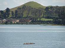
Ōtuataua, on the Ihumātao Peninsula, is located in the suburb of Māngere,[1] is one of the volcanoes in the Auckland volcanic field. The scoria cone reached 64 metres (210 ft) above sea level and was the site of a large Māori pā.
The volcanic cone of Ōtuataua is sited within the Ōtuataua Stonefields Historic Reserve and as the dominant landscape feature, lends the 100 hectare reserve its name. The cone provided a fortified village to the original inhabitants, with the lower slopes of the volcano supporting intensive Māori gardening. The volcanic soils extend all the way to the shoreline where there was access to the abundance of the Manukau Harbour. The sandy beaches and wide tidal flats were once rich with shellfish and the harbour provided fish and a regionally important shark fishery.[2]
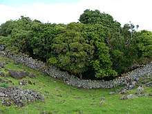
The Ōtuataua Stonefields are part of an area known as Ihumātao or Te Ihu a Mataoho “The Nose of Mataoho”. The Stonefields feature Māori stone garden mounds and Māori and European dry-stone walls; the visible histories of Ihumātao are interwoven with the history of Auckland, as it is possible to trace the history of human presence in Auckland from initial Māori settlement to the arrival of Europeans in the 1860s with their pastoral farming techniques.[3]
Regrettably the Ōtuataua cone was quarried in 1950s, and the scoria used for building work—including the building of Auckland Airport. At the completion of quarrying, remedial reconstruction created a shallow, grassy crater.
Adjacent to Ōtuataua in the Ōtuataua Stonefields Historic Reserve lies Pukeiti, Auckland's shortest volcano.
Occupation
A group set up camp beside the road leading to the Ōtuataua Stonefields on 4 November 2016.[4] This was undertaken by them as a last step to prevent a planned development by Fletcher Building.[5]
References
- ↑ "Ōtuataua Stonefields". www.aucklandcouncil.govt.nz. Retrieved 7 December 2015.
- ↑ "Ōtuataua Stonefileds" Māngere Gateway Heritage project
- ↑ Stuff: "Report: rock walls prove 'historic Māori farming' practices"
- ↑ "A Time and a Place: Ōtuataua Stonefields Historic Reserve peaceful occupation". Stuff. Retrieved 14 March 2017.
- ↑ "Tent embassy erected to prevent Ihumātao development". Māori Television. Retrieved 14 March 2017.
- City of Volcanoes: A geology of Auckland – Searle, Ernest J.; revised by Mayhill, R.D.; Longman Paul, 1981. First published 1964. ISBN 0-582-71784-1.
External links
- Ōtuataua Stonefields Historic Reserve
- 1930 view of Ōtuataua (Quarry Hill).
- Aerial view of Ōtuataua when still being quarried.