Orakei Basin
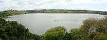
View of Orakei Basin looking north-east.
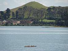
Orakei Basin is one of the volcanoes in the Auckland volcanic field. It has an explosion crater around 700 m wide, with a surrounding tuff ring. After eruption about 85,000 years ago, it became a freshwater lake that had an overflow stream in the vicinity of present Orakei Rd bridge. As sea level rose after the end of the Last Ice Age, the lake, which by then had shallowed to a swamp, was breached by the sea and has been a tidal lagoon ever since. A tidal lagoon, it is popular for watersports. A railway line (the North Island Main Trunk, branded as the Eastern Line for suburban services) runs through the north side of the basin.
References
- City of Volcanoes: A geology of Auckland - Searle, Ernest J.; revised by Mayhill, R.D.; Longman Paul, 1981. First published 1964. ISBN 0-582-71784-1.
- Volcanoes of Auckland: The Essential Guide. Hayward, B.W., Murdoch, G., Maitland, G.; Auckland University Press, 2011.
External links
- Photographs of Orakei Basin held in Auckland Libraries' heritage collections.
Coordinates: 36°52′02″S 174°48′47″E / 36.867124°S 174.81308°E
| Wikimedia Commons has media related to Orakei Basin. |
This article is issued from
Wikipedia.
The text is licensed under Creative Commons - Attribution - Sharealike.
Additional terms may apply for the media files.