Matukutururu
| Wiri Mountain | |
|---|---|
| Te Manurewa o Tamapahore | |
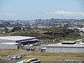
.jpg) The quarried remains of Matukutūruru, when part-filled with water. Picture is taken from some of the higher remnants. | |
| Highest point | |
| Elevation | 80 m (260 ft) |
| Coordinates | 37°00′26″S 174°51′30″E / 37.007334°S 174.858441°ECoordinates: 37°00′26″S 174°51′30″E / 37.007334°S 174.858441°E |
| Geography | |
| Location | Wiri, North Island, New Zealand |
| Geology | |
| Volcanic arc/belt | Auckland volcanic field |
Matukutūruru (also Te Manurewa o Tamapahore or Wiri Mountain) is a volcano in Wiri, in the Auckland volcanic field. It had a scoria cone reaching 80 metres above sea level (around 50 m higher than the surrounding land), which was quarried away. The lava flows created 290m long Wiri Lava Cave. The hill was the site of a pā. In late 2011 the quarry lake was drained and fill-dumping began on the site.
Matukutūruru and nearby Matukutūreia are collectively known as Matukurua (also ngā Matukurua).[1]
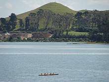
 The quarried remnants of Wiri Mountain as seen from Matukutūreia.
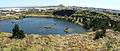 Wiri quarry when part-filled with water, looking toward Matukutūreia.
References
- ↑ Manurewa Marae Website "A Tale of Manurewa" Archived 2010-06-02 at the Wayback Machine.
- City of Volcanoes: A geology of Auckland - Searle, Ernest J.; revised by Mayhill, R.D.; Longman Paul, 1981. First published 1964. ISBN 0-582-71784-1.
External links
- 1957 view of Wiri Mountain
- View south from Mount Smart in 1923. Wiri Mountain is the distant hill on the left.
This article is issued from
Wikipedia.
The text is licensed under Creative Commons - Attribution - Sharealike.
Additional terms may apply for the media files.