Kaimondake volcano
| Kaimondake | |
|---|---|
| 開聞岳 | |
 | |
| Highest point | |
| Elevation | 924 m (3,031 ft) |
| Coordinates | 31°10′48″N 130°31′42″E / 31.18000°N 130.52833°ECoordinates: 31°10′48″N 130°31′42″E / 31.18000°N 130.52833°E |
| Geography | |
| Geology | |
| Mountain type | stratovolcano |
| Last eruption | 885[1] |

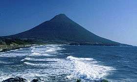
Kaimondake (開聞岳 Kaimondake, Kaimon-dake), or Mount Kaimon, is an undissected volcano – consisting of a basal stratovolcano and a small central volcano, part of the Ibusuki field – which rises to a height of 924 metres above sea level near the city of Ibusuki in southern Kyūshū, Japan. The last eruption occurred in the year 885. Kaimondake is sometimes referred to as "the Fuji of Satsuma".
 An aerial photograph of Kaimondake
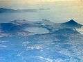 Lake Ikeda (centre left) and Mount Kaimon (right)
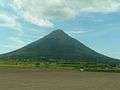 As seen from a JR Ibusuki Makurazaki Line train
| Wikimedia Commons has media related to Mount Kaimon. |
See also
References
External links
- Kaimondake - Japan Meteorological Agency (in Japanese)
- "Kaimondake: National catalogue of the active volcanoes in Japan" (PDF). - Japan Meteorological Agency
- "Ibusuki Volcanic Field". Global Volcanism Program. Smithsonian Institution.
| Hokkaidō | |||||||||
|---|---|---|---|---|---|---|---|---|---|
| Tōhoku region Jōshinetsu region |
| ||||||||
| Kantō region | |||||||||
| Chūbu region |
| ||||||||
| Western Japan | |||||||||
| |||||||||
This article is issued from
Wikipedia.
The text is licensed under Creative Commons - Attribution - Sharealike.
Additional terms may apply for the media files.