Mount Arafat

Mount Arafat or Mount Arafah (Arabic: جبل عرفات transliterated Jabal ‘Arafāt) is a granite hill east of Mecca in the plain of Arafat. Arafat is a plain about 20 km (12 mi) southeast of Mecca.[1] Mount Arafat reaches about 70 m (230 ft) in height and is also known as the Mount of Mercy (Jabal ar-Rahmah). According to Islamic tradition, the hill is the place where the Islamic prophet Muhammed stood and delivered the Farewell Sermon to the Muslims who had accompanied him for the Hajj towards the end of his life. Muslims also say that it is also the place where the Adam and Eve reunited on earth after falling from Heaven. It is the place where Adam was forgiven, hence it is also known as Jabl-ar-Rahmah (the Mount of Mercy). A pillar is erected to show the place where the aforementioned took place.
On the 9th of the month of Dhu al-Hijjah pilgrims go to Arafat from Mina, for the most important part of the Hajj. The Khutbah of Hajj is narrated and Zuhr prayer and Asr prayer are prayed together. The pilgrims spend the whole day on the mountain to supplicate to Allah to forgive their sins and to pray for personal strength in the future.
Hajj
Arafah rituals end at sunset and pilgrims then move to Muzdalifah for Maghrib Prayer and a shortened Isha prayer and for a short rest.
The level area surrounding the hill is called the Plain of Arafat. The term Mount Arafah is sometimes applied to this entire area. It is an important place in Islam because during the Hajj, pilgrims spend the afternoon there on the ninth day of Dhul Hijjah (ذو الحجة). Failure to be present in the plain of Arafat on the required day invalidates the pilgrimage.
Since late 2010, this place is served by Makkah Metro. On a normal Hajj, it would be around 21 km (13 mi) to walk.
In literature
The hill is also referenced in James Joyce's novel Finnegans Wake.[2]
See also
References
- ↑ "خرائط Google". خرائط Google.
- ↑ "Finnegans Wake". www.finwake.com. Retrieved 2016-07-18.
External links

Coordinates: 21°21′17″N 39°59′03″E / 21.354741°N 39.984049°E
Hajj topics | ||
|---|---|---|
Every year, from the eighth to the twelfth day of Dhu al-Hijjah. | ||
| Preparation | 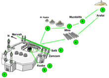 | |
| Sequence | ||
| Mosques | ||