Morbi district
| Morbi (By Milan Gohel ) | |
|---|---|
| district | |
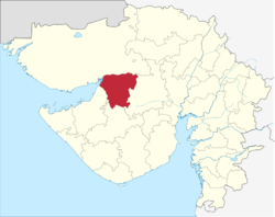 Location in Gujarat | |
| Country | India |
| State | Gujarat |
| Region | Saurashtra |
| Headquarters | Morbi |
| Area | |
| • Total | 4,871.5 km2 (1,880.9 sq mi) |
| Population (2011) | |
| • Total | 960,329 |
| • Density | 200/km2 (510/sq mi) |
| Languages | |
| • Official | Gujarati, Hindi |
| Time zone | UTC+5:30 (IST) |
| Vehicle registration | GJ-36 |
| Website | http://morbi.gujarat.gov.in/ |
Morbi District is in the state of Gujarat, India. It was formed on August 15, 2013, along with several other districts, on the 67th Independence Day of India.[1][2] Morbi city is the administrative headquarters of the district.The district has 5 talukas - Morbi, Maliya, Tankara, Wankaner (previously in Rajkot district) and Halvad (previously in Surendranagar district). Morbi city is the administrative headquarters of Morbi district. The town of Morbi is situated on the Machchhu River, 35 km from the sea and 60 km from Rajkot. As per 2011 census data, the city had a population of 2,10,451 and average literacy rate of 83.64%.
This district is surrounded by Kutch district to the north, Surendranagar district to the east, Rajkot district to the south and Jamnagar district to the west.
Origin of the name
The district is named after Morbi city. The name of the city of Morbi (literally meaning the city of peacocks) was probably derived from the King of Bhuj.
Demographics
Morbi district has an approx. population of 9,60,329. Morbi district has an area of approx. 4,871.5 km2. and a density of 207.
The district has 5 talukas - Morbi, Maliya, Tankara, Wankaner (previously in Rajkot district) and Halvad (previously in Surendranagar district).
References
- ↑ "Next Republic Day, Gujarat will be bigger..." Indian Express. 7 October 2012. Retrieved 19 October 2012.
- ↑ http://articles.timesofindia.indiatimes.com/2013-08-14/ahmedabad/41408891_1_districts-talukas-independence-day
Places adjacent to Morbi district | |
|---|---|
| Topics | 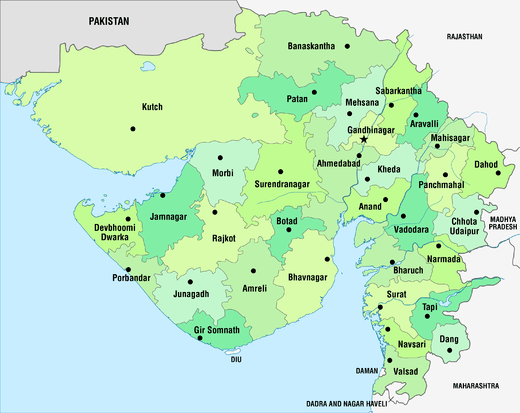 | |
|---|---|---|
| Regions of Gujarat | ||
| Districts | ||
| Major cities | ||
| Ecoregions | ||
| Economy |
| |
| ||