Montrésor
| Montrésor | ||
|---|---|---|
| Commune | ||
 Château de Montrésor | ||
| ||
 Montrésor Location within Centre-Val de Loire region  Montrésor | ||
| Coordinates: 47°09′24″N 1°12′06″E / 47.1567°N 1.2017°ECoordinates: 47°09′24″N 1°12′06″E / 47.1567°N 1.2017°E | ||
| Country | France | |
| Region | Centre-Val de Loire | |
| Department | Indre-et-Loire | |
| Arrondissement | Loches | |
| Canton | Loches | |
| Intercommunality | CC Loches Sud Touraine | |
| Government | ||
| • Mayor (2014–2020) | Christophe Unrug | |
| Area1 | 0.98 km2 (0.38 sq mi) | |
| Population (2009)2 | 330 | |
| • Density | 340/km2 (870/sq mi) | |
| Time zone | UTC+1 (CET) | |
| • Summer (DST) | UTC+2 (CEST) | |
| INSEE/Postal code | 37157 /37460 | |
| Elevation | 87–121 m (285–397 ft) | |
|
1 French Land Register data, which excludes lakes, ponds, glaciers > 1 km2 (0.386 sq mi or 247 acres) and river estuaries. 2 Population without double counting: residents of multiple communes (e.g., students and military personnel) only counted once. | ||
.svg.png)
Montrésor is a commune in the Indre-et-Loire department in central France.
Geography
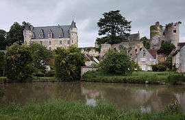
The village lies on the right bank of the Indrois, which flows northwest through the middle of the commune.

View over Montrésor, 1981
Population
| Historical population | ||||||||||||||||||||||||||||||||||||||||||||||||||||||||||||||||||||||||||||||||||||||||||||||||||||||||||||||||
|---|---|---|---|---|---|---|---|---|---|---|---|---|---|---|---|---|---|---|---|---|---|---|---|---|---|---|---|---|---|---|---|---|---|---|---|---|---|---|---|---|---|---|---|---|---|---|---|---|---|---|---|---|---|---|---|---|---|---|---|---|---|---|---|---|---|---|---|---|---|---|---|---|---|---|---|---|---|---|---|---|---|---|---|---|---|---|---|---|---|---|---|---|---|---|---|---|---|---|---|---|---|---|---|---|---|---|---|---|---|---|---|---|
|
| |||||||||||||||||||||||||||||||||||||||||||||||||||||||||||||||||||||||||||||||||||||||||||||||||||||||||||||||
See also
References
| Wikimedia Commons has media related to Montrésor. |
This article is issued from
Wikipedia.
The text is licensed under Creative Commons - Attribution - Sharealike.
Additional terms may apply for the media files.