Charnizay
| Charnizay | |
|---|---|
| Commune | |
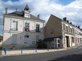 Town hall | |
 Charnizay Location within Centre-Val de Loire region  Charnizay | |
| Coordinates: 46°54′51″N 0°59′13″E / 46.9142°N 0.9869°ECoordinates: 46°54′51″N 0°59′13″E / 46.9142°N 0.9869°E | |
| Country | France |
| Region | Centre-Val de Loire |
| Department | Indre-et-Loire |
| Arrondissement | Loches |
| Canton | Descartes |
| Intercommunality | CC Loches Sud Touraine |
| Government | |
| • Mayor (2008–2014) | Claude Villeret |
| Area1 | 51.71 km2 (19.97 sq mi) |
| Population (2009)2 | 490 |
| • Density | 9.5/km2 (25/sq mi) |
| Time zone | UTC+1 (CET) |
| • Summer (DST) | UTC+2 (CEST) |
| INSEE/Postal code | 37061 /37290 |
| Elevation | 84–147 m (276–482 ft) |
|
1 French Land Register data, which excludes lakes, ponds, glaciers > 1 km2 (0.386 sq mi or 247 acres) and river estuaries. 2 Population without double counting: residents of multiple communes (e.g., students and military personnel) only counted once. | |
Charnizay is a commune in the Indre-et-Loire department in central France.
History
In 1794, Charnizay annexed the commune of Saint Michel des Landes.
Population
| Historical population | ||
|---|---|---|
| Year | Pop. | ±% |
| 1936 | 1,004 | — |
| 1946 | 1,023 | +1.9% |
| 1954 | 1,005 | −1.8% |
| 1962 | 930 | −7.5% |
| 1968 | 876 | −5.8% |
| 1975 | 738 | −15.8% |
| 1982 | 615 | −16.7% |
| 1990 | 557 | −9.4% |
| 1999 | 523 | −6.1% |
| 2006 | 489 | −6.5% |
| 2009 | 490 | +0.2% |
Sights
- Dolmen le Palet de Gargantua , near the hamlet of Les Champs de l'Ormeau
Personalities
- Charles de Menou d'Aulnay (1604–1650), named governor of Acadia in 1638.
See also
References
| Wikimedia Commons has media related to Charnizay. |
This article is issued from
Wikipedia.
The text is licensed under Creative Commons - Attribution - Sharealike.
Additional terms may apply for the media files.