Bossay-sur-Claise
| Bossay sur Claise | ||
|---|---|---|
| Commune | ||
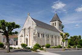 The church of Saint-Martin, in Bossay-sur-Claise | ||
| ||
 Bossay sur Claise Location within Centre-Val de Loire region  Bossay sur Claise | ||
| Coordinates: 46°49′59″N 0°57′47″E / 46.8331°N 0.9631°ECoordinates: 46°49′59″N 0°57′47″E / 46.8331°N 0.9631°E | ||
| Country | France | |
| Region | Centre-Val de Loire | |
| Department | Indre-et-Loire | |
| Arrondissement | Loches | |
| Canton | Descartes | |
| Intercommunality | CC Loches Sud Touraine | |
| Government | ||
| • Mayor (2008–2014) | Jean Bois | |
| Area1 | 65.56 km2 (25.31 sq mi) | |
| Population (2009)2 | 824 | |
| • Density | 13/km2 (33/sq mi) | |
| Time zone | UTC+1 (CET) | |
| • Summer (DST) | UTC+2 (CEST) | |
| INSEE/Postal code | 37028 /37290 | |
| Elevation | 67–144 m (220–472 ft) | |
|
1 French Land Register data, which excludes lakes, ponds, glaciers > 1 km2 (0.386 sq mi or 247 acres) and river estuaries. 2 Population without double counting: residents of multiple communes (e.g., students and military personnel) only counted once. | ||
.svg.png)
Bossay-sur-Claise is a commune in the Indre-et-Loire department in central France.
Population
| Historical population | ||
|---|---|---|
| Year | Pop. | ±% |
| 1936 | 1,441 | — |
| 1946 | 1,435 | −0.4% |
| 1954 | 1,339 | −6.7% |
| 1962 | 1,276 | −4.7% |
| 1968 | 1,192 | −6.6% |
| 1975 | 1,038 | −12.9% |
| 1982 | 915 | −11.8% |
| 1990 | 867 | −5.2% |
| 1999 | 787 | −9.2% |
| 2006 | 818 | +3.9% |
| 2009 | 824 | +0.7% |
See also
References
| Wikimedia Commons has media related to Bossay-sur-Claise. |
This article is issued from
Wikipedia.
The text is licensed under Creative Commons - Attribution - Sharealike.
Additional terms may apply for the media files.