Le Louroux
| Le Louroux | |
|---|---|
| Commune | |
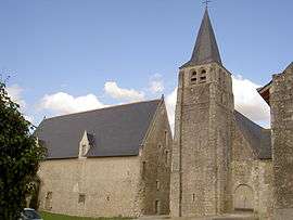 The church of Saint-Sulpice, in Le Louroux | |
 Le Louroux Location within Centre-Val de Loire region  Le Louroux | |
| Coordinates: 47°09′41″N 0°47′14″E / 47.1614°N 0.7872°ECoordinates: 47°09′41″N 0°47′14″E / 47.1614°N 0.7872°E | |
| Country | France |
| Region | Centre-Val de Loire |
| Department | Indre-et-Loire |
| Arrondissement | Loches |
| Canton | Descartes |
| Intercommunality | CC Loches Sud Touraine |
| Government | |
| • Mayor (2008–2014) | Marie Claude Boquet |
| Area1 | 28.87 km2 (11.15 sq mi) |
| Population (2009)2 | 466 |
| • Density | 16/km2 (42/sq mi) |
| Time zone | UTC+1 (CET) |
| • Summer (DST) | UTC+2 (CEST) |
| INSEE/Postal code | 37136 /37240 |
| Elevation | 79–127 m (259–417 ft) |
|
1 French Land Register data, which excludes lakes, ponds, glaciers > 1 km2 (0.386 sq mi or 247 acres) and river estuaries. 2 Population without double counting: residents of multiple communes (e.g., students and military personnel) only counted once. | |
Le Louroux is a commune in the Indre-et-Loire department in central France.
Population
| Historical population | ||
|---|---|---|
| Year | Pop. | ±% |
| 1793 | 611 | — |
| 1800 | 699 | +14.4% |
| 1806 | 820 | +17.3% |
| 1821 | 783 | −4.5% |
| 1831 | 701 | −10.5% |
| 1836 | 697 | −0.6% |
| 1841 | 703 | +0.9% |
| 1846 | 747 | +6.3% |
| 1851 | 673 | −9.9% |
| 1856 | 650 | −3.4% |
| 1861 | 654 | +0.6% |
| 1866 | 651 | −0.5% |
| 1872 | 623 | −4.3% |
| 1876 | 630 | +1.1% |
| 1881 | 634 | +0.6% |
| 1886 | 585 | −7.7% |
| 1891 | 564 | −3.6% |
| 1896 | 588 | +4.3% |
| 1901 | 585 | −0.5% |
| 1906 | 589 | +0.7% |
| 1911 | 605 | +2.7% |
| 1921 | 576 | −4.8% |
| 1926 | 545 | −5.4% |
| 1931 | 552 | +1.3% |
| 1936 | 500 | −9.4% |
| 1946 | 484 | −3.2% |
| 1954 | 481 | −0.6% |
| 1962 | 458 | −4.8% |
| 1968 | 443 | −3.3% |
| 1975 | 365 | −17.6% |
| 1982 | 353 | −3.3% |
| 1990 | 373 | +5.7% |
| 1999 | 425 | +13.9% |
| 2006 | 464 | +9.2% |
| 2009 | 466 | +0.4% |
See also
References
| Wikimedia Commons has media related to Le Louroux. |
This article is issued from
Wikipedia.
The text is licensed under Creative Commons - Attribution - Sharealike.
Additional terms may apply for the media files.