Artannes-sur-Indre
| Artannes-sur-Indre | ||
|---|---|---|
| Commune | ||
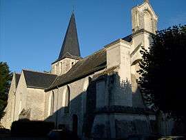 The church in Artannes-sur-Indre | ||
| ||
 Artannes-sur-Indre Location within Centre-Val de Loire region  Artannes-sur-Indre | ||
| Coordinates: 47°16′28″N 0°36′00″E / 47.2744°N 0.6°ECoordinates: 47°16′28″N 0°36′00″E / 47.2744°N 0.6°E | ||
| Country | France | |
| Region | Centre-Val de Loire | |
| Department | Indre-et-Loire | |
| Arrondissement | Tours | |
| Canton | Monts | |
| Intercommunality | CC Touraine Vallée Indre | |
| Government | ||
| • Mayor (2014-2020) | Bertrand Poitou | |
| Area1 | 20.97 km2 (8.10 sq mi) | |
| Population (2015)2 | 2,615 | |
| • Density | 120/km2 (320/sq mi) | |
| Time zone | UTC+1 (CET) | |
| • Summer (DST) | UTC+2 (CEST) | |
| INSEE/Postal code | 37006 /37260 | |
| Elevation | 47–98 m (154–322 ft) | |
|
1 French Land Register data, which excludes lakes, ponds, glaciers > 1 km2 (0.386 sq mi or 247 acres) and river estuaries. 2 Population without double counting: residents of multiple communes (e.g., students and military personnel) only counted once. | ||
.svg.png)
Artannes-sur-Indre is a commune in the Indre-et-Loire department in central France.
Population
| Historical population | ||
|---|---|---|
| Year | Pop. | ±% |
| 1793 | 1,071 | — |
| 1800 | 1,006 | −6.1% |
| 1806 | 1,095 | +8.8% |
| 1821 | 960 | −12.3% |
| 1831 | 1,084 | +12.9% |
| 1836 | 1,084 | +0.0% |
| 1841 | 1,103 | +1.8% |
| 1846 | 1,095 | −0.7% |
| 1851 | 1,074 | −1.9% |
| 1856 | 1,112 | +3.5% |
| 1861 | 1,105 | −0.6% |
| 1866 | 1,115 | +0.9% |
| 1872 | 1,080 | −3.1% |
| 1876 | 1,130 | +4.6% |
| 1881 | 1,073 | −5.0% |
| 1886 | 1,129 | +5.2% |
| 1891 | 1,152 | +2.0% |
| 1896 | 1,070 | −7.1% |
| 1901 | 1,059 | −1.0% |
| 1906 | 1,118 | +5.6% |
| 1911 | 1,073 | −4.0% |
| 1921 | 1,011 | −5.8% |
| 1926 | 1,056 | +4.5% |
| 1931 | 961 | −9.0% |
| 1936 | 996 | +3.6% |
| 1946 | 1,093 | +9.7% |
| 1954 | 1,132 | +3.6% |
| 1962 | 1,165 | +2.9% |
| 1968 | 1,154 | −0.9% |
| 1975 | 1,217 | +5.5% |
| 1982 | 1,402 | +15.2% |
| 1990 | 2,089 | +49.0% |
| 1999 | 2,184 | +4.5% |
| 2005 | 2,508 | +14.8% |
| 2006 | 2,519 | +0.4% |
| 2009 | 2,494 | −1.0% |
| 2015 | 2,615 | +4.9% |
See also
References
| Wikimedia Commons has media related to Artannes-sur-Indre. |
This article is issued from
Wikipedia.
The text is licensed under Creative Commons - Attribution - Sharealike.
Additional terms may apply for the media files.