Montavilla, Portland, Oregon
| Montavilla | |
|---|---|
| Neighborhood | |
 Montavilla | |
|
Coordinates: 45°31′35″N 122°34′45″W / 45.52642°N 122.57904°WCoordinates: 45°31′35″N 122°34′45″W / 45.52642°N 122.57904°W PDF map | |
| Country | United States |
| State | Oregon |
| City | Portland |
| Government | |
| • Association | Montavilla Neighborhood Association |
| • Coalition | Southeast Uplift |
| Area | |
| • Total | 2.18 sq mi (5.64 km2) |
| Population (2010)[1] | |
| • Total | 16,287 |
| • Density | 7,500/sq mi (2,900/km2) |
| Housing[1] | |
| • No. of households | 6,579 |
| • Occupancy rate | 95% occupied |
| • Owner-occupied | 3,817 households (58%) |
| • Renting | 2,762 households (42%) |
| • Avg. household size | 2.48 persons |
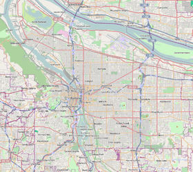
Montavilla (a syllabic abbreviation of "Mt. Tabor Village[2]) is a neighborhood in the Northeast and Southeast sections of Portland, Oregon, United States, and contains an area east of Mount Tabor and west of Interstate 205, from the Banfield to SE Division. It is bordered by North Tabor, Mount Tabor, Madison South, Hazelwood, and Powellhurst-Gilbert.
History
The neighborhood was originally, in the 1890s, named Mount Tabor Village, and was a stopping point for travelers going from Hood River into Portland. The name "Montavilla" originated from the abbreviations used on the streetcar destination signs when streetcars served the area starting in 1892. The name was first abbreviated as "Mt. Ta. Villa", then later as "Monta.Villa". Residents soon adopted the latter name for the neighborhood, written as Montavilla.[3] Streetcar service to Montavilla ended in 1948.[4]
A stone milepost marker, the P5 marker, on SE Stark Street at 78th Avenue is left over from the circa 1854 Base Line Road that extended from the Sandy River to the Willamette River. The milepost marks a distance of five miles to the downtown courthouse.[5] It is among the markers that indicate the Willamette baseline.
In the early-mid 1950s, the Asbahr Addition was developed between SE 89th and SE 92nd Avenues to the west and east, and SE Taylor and SE Harrison Streets to the north and south.[6] It is primarily made of ranch-style houses.
Chinese Village, a longtime neighborhood landmark, was demolished in July 2018; it was located on 82nd Avenue between SE Washington and Stark Streets.
The Monastery of the Precious Blood, a 1923 building on the National Register of Historic Places, is on 76th Avenue.
Community
Founded in 2010, the Montavilla Food Co-op is working to bring a cooperative grocery to the neighborhood, though it currently does not have a storefront.[7] Montavilla is home to the community organization Pollinator Parkways, which converts parking strips to wildlife habitat.[8] Montavilla Street Fair is held each summer, bringing community members and local businesses together on the Stark strip. The neighborhood is served by the local Mid-County Memo newspaper. The Montavilla Farmers Market is held on Sundays at 77th and Stark.[9] The southern portion of the neighborhood includes the Jade District commercial and cultural center.
Parks
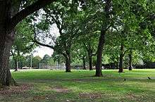
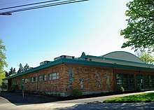
Montavilla is home to Montavilla Park, a 9.46 acre park established in 1921. It includes a Portland Timbers-sponsored futsal field, dedicated in August 2014.[10] Montavilla also includes Berrydale Park, Harrison Park, and Montavilla Community Center. Vestal Community Garden is located near Vestal school.
Schools
Vestal K-8 is located near the center of the neighborhood, immediately west of 82nd Avenue between E Burnside Street and NE Glisan Street. Creative Science School is a K-8 immediately west of 92nd Avenue and north of SE Hawthorne Boulevard.
Montavilla also includes higher education institutions. Multnomah University, a nondenominational Christian university, is located north of Glisan Street adjacent to Montavilla Park. Portland Community College Southeast campus is located at the southwest boundary of the neighborhood at 82nd Avenue and Division Street.
Stark Street
As a neighborhood center, SE Stark Street between 75th and 82nd Avenues provides a mix of commercial and retail services to residents and visitors. It is a place where people can socialize, run their errands, window shop, and dine at local restaurants. At the center of the area is the Academy Theater, built in 1948 and restored in 2006.[11]
Transportation
Three roads bounding Montavilla—Division, I-84, and I-205—are major transportation arteries, giving the neighborhood easy automobile access to the city center and outlying areas. Within Montavilla, Glisan, Burnside, and Stark Streets run east–west and 82nd Avenue runs north–south; all are major transportation streets served by TriMet bus lines. The Max serves one stop in Montavilla, at 82nd Avenue, and another at the Gateway Transit Center, just outside the boundary. The neighborhood is the future home to the Seventies Neighborhood Greenway, which will address a gap in north-south bicycle and pedestrian facilities near NE 82nd Avenue.[12] Current greenways run north–south approximately on 86th Avenue and east–west along Mill Street.[13]
82nd Avenue
The state-managed highway OR 213, locally referred to as 82nd Avenue, bisects the neighborhood from north to south. It is a highly commercial street that is directly surrounded by dense neighborhoods of primarily single-family homes. Because 82nd Avenue runs through the neighborhood, residents often cross this five-lane road for school, work, or recreation. The intersection of 82nd and Glisan Street is among the city's identified high-crash intersections, and it is ranked by the City of Portland as the most dangerous intersection within Portland for pedestrians, however no public plans have been announced to improve this intersection.[14][15] The intersections with SE Division and E Burnside are also identified as high-crash intersections. In an attempt to improve the quality of life around 82nd Avenue, the 82nd Avenue Improvement Coalition was formed;[16] among its main goals is the transfer of ownership of 82nd Avenue to City of Portland control, instead of state control.[17]
References
- 1 2 Demographics (2010)
- ↑ Nelson, Grant. "The early years of Mt. Tabor". Mount Tabor Neighborhood Association. Retrieved April 5, 2013.
- ↑ Thompson, Richard H. (2010). Portland's Streetcar Lines. Arcadia Publishing. p. 108. ISBN 978-0-7385-8126-2.
- ↑ Thompson (2010), pp. 98–99.
- ↑ https://www.portlandoregon.gov/bps/article/214638
- ↑ http://www.portlandonline.com/portlandplan/?a=346262
- ↑ http://montavilla.coop/our-story/
- ↑ http://pollinatorparkways.weebly.com/about.html
- ↑ "Montavilla Farmers Market | The freshest farmers market on Southeast Stark. Portland, OR". www.montavillamarket.org. Retrieved 2018-08-08.
- ↑ https://www.portlandoregon.gov/parks/finder/index.cfm?action=ViewPark&PropertyID=268
- ↑ https://www.lonelyplanet.com/usa/travel-tips-and-articles/hot-hoods-in-the-us-10-neighborhoods-you-need-to-visit/40625c8c-8a11-5710-a052-1479d2768df2
- ↑ "Seventies Neighborhood Greenway | ODOT Region 1 STIP". ODOT Region 1 STIP. Retrieved 2018-08-08.
- ↑ "PDF of Portland neighborhood greenways".
- ↑ "High Crash Network Intersections | The City of Portland, Oregon". www.portlandoregon.gov. Retrieved 2018-07-30.
- ↑ "High Crash Intersections". City of Portland. July 29, 2018.
- ↑ "82nd Avenue Improvement Coalition". www.facebook.com. Retrieved 2018-07-30.
- ↑ "Coalition wants 82nd in city's hands, not state's | Mid-county Memo". Mid-county Memo. 2018-01-11. Retrieved 2018-07-30.
External links

- Guide to Montavilla Neighborhood (PortlandNeighborhood.com)
- Montavilla Neighborhood Association
- Montavilla East Tabor Business Association
- Montavilla Street Tree Inventory