Neighborhoods of Portland, Oregon

There are five sections of Portland, Oregon[1], though a sixth is planned, and 95 officially recognized neighborhoods, each of which is represented by a volunteer-based neighborhood association. These associations serve as the liaison between residents and the city government, as coordinated by the city's Office of Community & Civic Life,[2] which was created in 1974 and known as the Office of Neighborhood Involvement until July 2018.[3] The city subsequently provides funding to this "network of neighborhoods" through district coalitions, which are groupings of neighborhood associations. On June 6, 2018, Portland City Council voted to add a sixth section to Portland; it will be called South Portland and the transition to the new system is expected to start in May 2020.[4]
Sections
Southwest

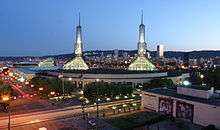
Downtown Portland lies in the Southwest section between the I-405 freeway loop and the Willamette River, centered on Pioneer Courthouse Square ("Portland's living room"). Downtown and many other parts of inner Portland have compact square blocks (200 ft [60 m] on a side) and narrow streets (64 ft [20 m] wide), a pedestrian-friendly combination.
Many of Portland's recreational, cultural, educational, governmental, business, and retail resources are concentrated downtown, including:
- South Park Blocks, Pettygrove and Lovejoy Fountain Parks, and Tom McCall Waterfront Park
- Arlene Schnitzer Concert Hall, Portland Art Museum, and Oregon Historical Society Museum
- Portland City Hall, Multnomah County Courthouse, the Portland Building, Pioneer Courthouse, and Mark O. Hatfield United States Courthouse
- Portland State University, the only public urban university in the state of Oregon that is located in a major metropolitan city
- The Meier & Frank Building and Pioneer Place mall
- Wells Fargo Center, the tallest building in Oregon (546 feet [166 m])
Beyond downtown, the Southwest section also includes:
- The campuses of Oregon Health & Science University (OHSU), Lewis & Clark College, and Portland Community College/Sylvania
- Neighborhoods like South Portland (formerly Corbett-Terwilliger-Lair Hill), South Burlingame, Hillsdale, and Multnomah, with unique residential houses and well defined commercial and retail districts
- Alpenrose Dairy in the Hayhurst neighborhood, the grounds of which host track cycling and Little League sports
- Washington Park, site of North America's deepest transit station, the Oregon Zoo, Hoyt Arboretum, the International Rose Test Garden, the Portland Japanese Garden, the Vietnam Veterans Memorial, and many hiking trails.
- The south Willamette riverfront along SW Macadam Ave., over 100 acres (0.4 km²) of former industrial land. This area is undergoing redevelopment as a mixed-use, high-density neighborhood, with an anticipated 2,700 residential units and 5,000 high-tech jobs after build-out.
Northwest
Northwest Portland includes the Pearl District, most of Old Town Chinatown, the Northwest District, and various residential and industrial neighborhoods. A range of streets primarily in Northwest Portland is named alphabetically from Ankeny through York (the street following York is Reed Street). The street between Wilson and York was called "X Street" until it was renamed as Roosevelt Street.[5] Burnside Street, the "B" in the sequence, divides the Northeast and Northwest quadrants of the city from the Southeast and Southwest.
The Pearl District is a recent name for a former warehouse and industrial area just north of downtown. Many of the warehouses have been converted into lofts, and new multistory condominiums have also been developed on previously vacant land. The increasing density has attracted a mix of restaurants, brewpubs, shops, and art galleries. [6] The galleries sponsor simultaneous artists' receptions every month, in an event known as First Thursday.[7]
Between the Pearl District and the Willamette is the Old Town Chinatown neighborhood. It includes Portland's Chinatown, marked by a pair of lions at its entrance at NW 4th Ave. and W Burnside St. and home to the Portland Classical Chinese Garden. Before World War II, this area was known as Japan Town;[8] Chinatown was previously located just south of W. Burnside St. along the riverfront.
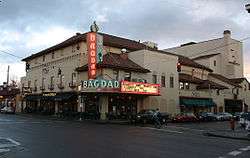
Farther west is the compact but thriving NW 21st and 23rd Avenue restaurant and retail area, the core of the Northwest District. Parts of this area are also called Uptown and Nob Hill.[9] Nicknames include Snob Hill and Trendy Third.[10] The residential areas adjacent to the shopping district include the Alphabet Historic District (with large Victorian and Craftsman homes built in the years before and shortly after 1900) and a large district centered on Wallace Park. The neighborhood has a mix of Victorian-era houses, apartment buildings from throughout the 20th century, and various businesses centered on Legacy Good Samaritan Medical Center. The Portland Streetcar connects Nob Hill to downtown, via the Pearl.
West of the developed areas is the northern portion of Portland's West Hills, including the majority of extensive Forest Park and the Willamette Heights, Hillside, Sylvan, Skyline and Forest Heights neighborhoods.
North

North Portland is a diverse mixture of residential, commercial, and industrial areas. It includes the Portland International Raceway, the University of Portland, and massive cargo facilities of the Port of Portland. Nicknames for it include "NoPo" and "the Fifth Quadrant" (for being the odd-man out from the four-cornered logic of SE, NE, SW, and NW).
North Portland is connected to the industrial area of Northwest Portland by the St. Johns Bridge, a 2,067 ft (630.0 m) long suspension bridge completed in 1931 and extensively rehabilitated in 2003-05.
During World War II, a planned development named Vanport was constructed to the north of this section between the city limits and the Columbia River. It grew to be the second largest city in Oregon, but was wiped out by a disastrous flood in 1948.[11] Columbia Villa, another wartime housing project in the Portsmouth Neighborhood, is being rebuilt; the renewed community opened in 2005[12] is known as New Columbia and offers public housing, rental housing, and single family home ownership units.[13] Since 2004, a light rail line runs along Interstate Avenue, which parallels I-5, stopping short of crossing the Columbia River.
Northeast
Northeast Portland contains a diverse collection of neighborhoods. For example, while Irvington and the Alameda Ridge feature some of the oldest and most expensive homes in Portland, nearby King is a more working-class neighborhood. Because it is so large, Northeast Portland can essentially be divided ethnically, culturally, and geographically into inner and outer sections. The inner Northeast neighborhoods that surround Martin Luther King Jr. Blvd. were once predominantly African American, resembling typical urban inner-city environments found in most major U.S. cities. However, the demographics are now changing due to the process of gentrification. In 2010, the King neighborhood was 25.9% Black or African-American, a 41.3% decrease since 2000.[14] Inner Northeast includes several shopping areas, such as the Lloyd District, Alberta Arts District (Portland, Oregon) and Hollywood, and part of the affluent Irvington, Alameda, Grant Park, Sullivan's Gulch and Laurelhurst neighborhoods and nearby developments. The city plan targets Lloyd District as another mixed-use area, with high-density residential development.
Straddling the base of the borders of North and Northeast is the Rose Quarter. It is named after the Rose Garden, home of the Portland Trail Blazers (now named the Moda Center), and also includes the Blazers' former home, the Memorial Coliseum. The Coliseum is the home to Portland's hockey team, the Portland Winter Hawks, of the Western Hockey League, though they often play at the Moda Center. The newest Rose Quarter tenants are the LumberJax of the National Lacrosse League. The city still holds the lease to the land and owns the Coliseum, but the Moda Center and other buildings were owned by private business interests until they went into receivership. The area is quite active during the teams' home games, and the city hopes to extend the activity by promoting a major increase in residential units in the quarter using zoning and tax incentives.
At the base of Northeast where its border meets Southeast, an area near the Burnside Bridge has been redeveloped into a bustling nightlife and entertainment district. The area features bars like The Chesterfield and music venues like The Doug Fir Lounge. In 2006, the area was established enough to get its own nickname: LoBU.[15]
Southeast
Southeast Portland stretches from the warehouses along the Willamette through historic Ladd's Addition to the Hawthorne and Belmont districts out to Gresham. Southeast Portland has blue-collar roots and has evolved to encompass a wide mix of backgrounds. The Hawthorne district in particular is known for its hippie/radical crowd and small subculturally oriented shops; not far away is Reed College, whose campus expands from Woodstock Boulevard to Steele Street, and from the 28th to the 39th Avenues.
Between the 1920s and the 1960s, Southeast was home to Lambert Gardens. Southeast Portland also features Mt. Tabor, a cinder cone volcano that has become one of Portland's more scenic and popular parks. Peacock Lane is a street known locally for lavish Christmas decorations and displays.
South
South Portland, once established in May 2020, will exist in the current South Waterfront, Collins View and Riverdale neighborhoods. It will be bordered to the east by the Willamette River and to the west by Southwest Naito Parkway and the Tryon Creek State Natural area.[16] The Portland City Council voted to establish this sixth sextant of the city in June 2018, primarily because of addressing concerns that created serious impediments to emergency services.
Official list of neighborhoods
Each neighborhood association defines its own boundaries, which may include areas outside of Portland city limits and (if mutually agreed) areas that overlap with other neighborhoods. Neighborhoods may span boundaries between the five sections (N, NE, SE, SW, and NW) of the city as well. The segmentation adopted here is based on Office of Community & Civic Life's district coalition model, under which each neighborhood is part of at most one coalition (though some neighborhoods are not included in any).
Neighbors West-Northwest (NWNW)
These are in Northwest Portland, except Arlington Heights, Goose Hollow, Portland Downtown, and Sylvan-Highlands, which are in Southwest Portland. Southwest Neighborhoods, Inc. (SWNI)
All are in Southwest Portland. North Portland Neighborhood Services (NPNS)
Most lie entirely within North Portland. Bridgeton, Hayden Island and Piedmont are split between North and Northeast sections. East Columbia is in Northeast Portland. Northeast Coalition of Neighborhoods (NECN)
Most lie entirely within Northeast Portland. Boise, Eliot, and Humboldt include areas in North Portland. |
Central Northeast Neighbors, Inc. (CNN)
All lie within Northeast Portland. East Portland Neighborhood Office (EPNO)
Argay, Parkrose, Parkrose Heights, Russell, Wilkes, and Woodland Park are in Northeast Portland. Glenfair and Hazelwood are split between Northeast and Southeast sections. Centennial, Lents, Mill Park, Pleasant Valley, and Powellhurst-Gilbert are in Southeast Portland. Southeast Uplift Neighborhood Program (SE Uplift)
All are entirely within Southeast Portland, except North Tabor, Laurelhurst, Kerns, and Montavilla, which are split between Northeast and Southeast sections and Ardenwald-Johnson Creek, which covers both Portland and Milwaukie. Unaffiliated with a coalition
Healy Heights lies within Southwest Portland. The Lloyd District is in Northeast Portland. |
Other areas and communities
- Alberta Arts District, an art, retail, and restaurant area in the King, Vernon, and Concordia neighborhoods
- Albina, a historical city which was consolidated into Portland in 1891
- The Belmont Area, a retail and residential area in the Buckman, Sunnyside, and Mt. Tabor neighborhoods
- Dunthorpe, an affluent unincorporated enclave just beyond the city limits, north of Lake Oswego
- Unincorporated areas near Portland proper in Washington County (unincorporated neighborhoods expanding into Washington County)
- East Portland, a historical city which was consolidated into Portland in 1891, not to be confused with the area of the same name that extends roughly east of I-205 to Portland's eastern boundary
- East Portland, the area of Portland generally east of I-205, where approximately one quarter of residents reside, but which has historically not received adequate city services.[17][18]
- The Hawthorne District, a retail, restaurant, and cultural district running through the Buckman, Hosford-Abernethy, Sunnyside, Richmond, and Mt. Tabor neighborhoods
- Maywood Park, a Northeast neighborhood incorporated as a separate city that is now completely surrounded by the city of Portland
- Peacock Lane, a quaint English village in the heart of Sunnyside Neighborhood has been treating the city of Portland to free holiday lighting displays each December since the 1940s
- Vanport, a city located in present-day North Portland destroyed by a flood in 1948
References
- ↑ Ordinance 61325: Street re-numbering report. Providing for renumbering of buildings and renaming of streets., Auditor of the City of Portland, February 28, 1933, retrieved 2017-08-09
- ↑ Office of Civic & Community Life, City of Portland. Accessed 2018-08-26.
- ↑ City council ordinance 189078, passed on July 18, 2018. Auditor's Office, City of Portland.
- ↑ Templeton, Amelia. "South Portland Becomes City's Newest Address Area". www.opb.org. Retrieved 2018-07-27.
- ↑ Ordinance 7446 in 1891, which renumbered street addresses, shows the alphabetical streets through York Street.
- ↑ The 15 Coolest Neighborhoods in the World in 2016, retrieved 13 November 2016
- ↑ Johnston, Greg (June 8, 2006). "Whether you run, roll, stroll or paddle, Portland's riverfront is the place to be". Seattle Post-Intelligencer.
- ↑ "Japanese Labor in Oregon". Ohs.org. Retrieved 2008-10-20.
- ↑ Nob Hill Neighborhood Guide Portlandneighborhood.com. Retrieved April 5, 2013.
- ↑ "Archived copy". Archived from the original on 2008-12-08. Retrieved 2009-01-03.
- ↑ Manley Maben, Vanport (Portland: Oregon Historical Society Press, 1987).
- ↑ "Archived copy" (PDF). Archived from the original (PDF) on 2008-12-17. Retrieved 2009-01-03. Relocation and Return
- ↑ "Smart Growth Resource Library: Smart Growth In Action: New Columbia Neighborhood, Portland, Oregon". Smartgrowth.org. Archived from the original on 2008-10-30. Retrieved 2008-10-20.
- ↑ https://www.portlandoregon.gov/oni/article/375918
- ↑ Portland neighborhoods receive some new nicknames Daily Journal of Commerce (Portland, OR), Nov 16, 2006 by Kennedy Smith
- ↑ Templeton, Amelia. "South Portland Becomes City's Newest Address Area". www.opb.org. Retrieved 2018-07-27.
- ↑ Templeton, Amelia. "Audit Finds East Portland Lags Behind In Sidewalks, Parks". www.opb.org. Retrieved 2018-07-27.
- ↑ "The Other Portland". Willamette Week. Retrieved 2018-07-27.
External links
- Office of Community & Civic Life
- PortlandNeighborhood.com - includes neighborhood guides and a clickable map
- PortlandMaps.com - city's public GIS database, including demographic and other statistics on the neighborhoods, as well as official boundaries
- Map of Neighborhood Associations and Coalitions, Small
- Map of Neighborhood Associations and Coalitions, Large
- List of individual neighborhood maps
- Study of Portland Neighborhood Associations: Neighborhood Association Survey Results (League of Women Voters of Portland, June 2006)
