Minquan West Road MRT station
Minquan W. Rd. R13 / O11 民權西路 | |
|---|---|
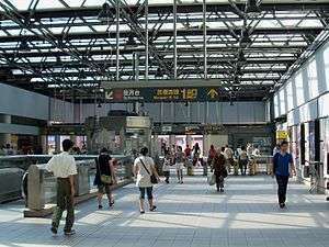 Station lobby | |
| Location |
No. 72, Minquan West Road Zhongshan and Datong, Taipei Taiwan |
| Operated by | |
| Line(s) |
|
| Connections | Bus stop |
| Construction | |
| Structure type | Underground |
| History | |
| Opened | 28 March 1997 |
| Traffic | |
| Passengers |
45,622 daily (2016)[1] (Ranked 29th of 109) |
| Minquan West Road MRT station | |||||||||||||||||||||
| Traditional Chinese | 民權西路站 | ||||||||||||||||||||
|---|---|---|---|---|---|---|---|---|---|---|---|---|---|---|---|---|---|---|---|---|---|
| Simplified Chinese | 民权西路站 | ||||||||||||||||||||
| |||||||||||||||||||||
The Taipei Metro Minquan West Road station (formerly Minchuan West Road Station until 2003) is located in between the Zhongshan and Datong districts of Taipei, Taiwan. It is a transfer station for the Tamsui Line and the Xinzhuang Line.
Station overview
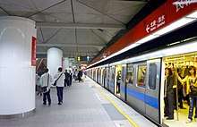
The station is a three-level, underground structure with two island platforms and ten exits.[2] The washrooms are inside the entrance areas.
The station is situated on Minquan West Road, near Chengde Road. The Red Line station is underneath the metro park, while the Orange Line station is located underneath Minquan West Road.
History
The station was opened on 28 March 1997 for the Tamsui-Xinyi Line. On 1 June 2003; the Xinzhuang Line construction began on the still-operational station.[3][4] This station was opened on 3 November 2010 for the Xinzhuang Line.
Construction
With the opening of the Xinzhuang Line, the station became a three-level underground station with two cross island platforms.[3][5] Excavation depth is at around 22 meters. The Xinzhuang Line station is 235 meters long and 26 meters wide, with six additional entrances, two vent shafts, and an accessibility elevator.
Station layout
| L1 | Tamsui LineConcourse | Entrance/Exit, lobby, information desk, automatic ticketing machines, one-way faregates 7-Eleven (Outside fare zone), Restrooms (North side, inside fare zone) |
| B1 | ||
| Underpass | ||
| (Outside fare zone, near exit 1. Access to Fushun St. and Minquan W. Road) | ||
| Platform 1 | ← | |
| Island platform, doors will open on the left | ||
| Platform 2 | → | |
| B2 | Xinzhuang LineConcourse | Escalator to Tamsui Line Concourse Level, Exits 5-10 Information desk, automatic ticket machines, one-way faregates Restrooms (West side, outside fare zone; East side, inside fare zone) |
| B3 | Platform 3 | ← |
| Island platform, doors will open on the left | ||
| Platform 4 | → | |
Exits
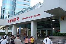
- Exit 1: Minquan W. Rd. (South side of Minquan W. Rd.)

- Exit 2: Jinxi St. (Beside the Chengyuan High School)
- Exit 3: South Plaza (On the linear park)
- Exit 4: Tianxiang Rd. (Lane 70, Minquan W. Rd.)
- Exit 5: Chengde Rd. Sec. 3 (Fushun Rd., near Chengde Rd.)
- Exit 6: Chengyuan High School (Southeast side of the intersection of Minquan W. Rd. and Chengde Rd.)
- Exit 7: Zhongshan N. Rd. Sec. 2 (Southwest side of the intersection of Minquan W. Rd. and Tianxiang Rd.)
- Exit 8: Zhongshan N. Rd. Sec. 2 (Southwest side of the intersection of Minquan W. Rd. and Tianxiang Rd.)
- Exit 9: Zhongshan N. Rd. Sec. 3 (Northwest side of the intersection of Minquan W. Rd. and Tianxiang Rd.)
- Exit 10: Zhongshan N. Rd. Sec. 3 (Northwest side of the intersection of Minquan W. Rd. and Tianxiang Rd.)
Around the station
- Chiang Wei-shui Memorial Park
- Taipei Bridge
- Tatung University
- Tatung Company Headquarters
- Wunchang Temple[6]
- Zhongshan North Road Wedding Dress Road
- United Bus Services Minquan W. Rd. Station
- Taipei Tatung Recreation Center (between this station and Yuanshan station)
- Chengyuan Senior High School
- Datong Elementary School
- Shuanglian Elementary School
- Hotel Sunroute Taipei (between this station and Zhongshan Elementary School station)
- Fudu Hotel
- Jinxi Park
- Datong Police Department
| Preceding station | Following station | |||
|---|---|---|---|---|
| Yuanshan | Tamsui–Xinyi line | Shuanglian | ||
| Daqiaotou | Zhonghe–Xinlu line | Zhongshan Elementary School towards Nanshijiao | ||
References
| Wikimedia Commons has media related to Minquan West Road Station. |
- ↑ "Passenger Volume at Taipei Rapid Transit Stations" (PDF). Taipei City Department of Transportation. 2017-03-13. Retrieved 2017-03-13.
- ↑ "Route Map: Minquan West Road". Taipei Rapid Transit Corporation. Retrieved 2010-11-30.
- 1 2 "工程線上 Status Report: 新莊線民權西路站". Department of Rapid Transit Systems. 2006-04-01. Retrieved 2010-06-19.
- ↑ "Introduction to Minquan W. Rd. Station on the Xinzhuang Line". Department of Rapid Transit Systems. 2006-04-01. Retrieved 2010-07-24.
- ↑ "Introduction to Xinzhuang MRT Line" (PDF). Department of Rapid Transis Systems. 2008-03-01. Archived from the original (PDF) on 2013-09-21. Retrieved 2010-06-18.
- ↑ "文昌宮". Retrieved 2010-08-22.
Coordinates: 25°03′44″N 121°31′11″E / 25.062179°N 121.519687°E
| Stations |
| ||||||
|---|---|---|---|---|---|---|---|
| Rolling stock |
| ||||||
| Stations |
| ||||||
|---|---|---|---|---|---|---|---|
| Rolling stock |
| ||||||