Shipai MRT station
Shipai R19 石牌 | |
|---|---|
 Shipai station | |
| Other names | Veterans General Hospital; 榮總 |
| Location |
No. 200, Sec. 1, Shipai Rd. Beitou, Taipei Taiwan |
| Operated by | |
| Line(s) |
|
| Connections | Bus stop |
| Construction | |
| Structure type | Elevated |
| History | |
| Opened | 28 March 1997 |
| Traffic | |
| Passengers |
57,695 daily (2016)[1] (Ranked 18th of 109) |
| Shipai MRT station | |||||||||||||
| Chinese | 石牌站 | ||||||||||||
|---|---|---|---|---|---|---|---|---|---|---|---|---|---|
| |||||||||||||
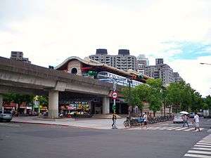
The Taipei Metro Shipai station is located in the Beitou District of Taipei City, Taiwan. It is a station on the Tamsui Line (Red Line). In the past, the station belonged to the now-defunct TRA Tamsui Line.
Station overview
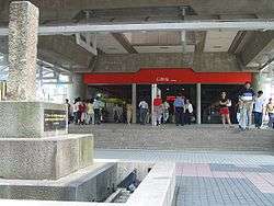
The two-level elevated station and features an island platform and has two exits.[2] One exit is located at the intersection of Shipai Rd., Donghua St., and Xian St facing north and the newly built exit is at the other end of the station facing south.
This station connects to Beitou Refuse Incineration Plant, Children's Art Museum in Taipei, National Research Institute of Chinese Medicine, National Taipei University of Nursing and Health Science, National Yang Ming University, Taipei American School, Taipei Veterans General Hospital and University of Taipei.
History
This station was opened as Qili-an on 17 August 1915 under the Taipei Railway Administration, and was renamed to Shipai after the war. The old TRA entrance was at Ziqiang Street, Lane 141. It was closed on 15 July 1988 and reopened on 28 March 1997. The second exit opened for use on 20 November 2010.[3]
Station layout
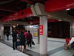
| 2F | Platform 1 | ← |
| Island platform, doors will open on the left | ||
| Platform 2 | → | |
| Street Level | Concourse | Entrance/Exit, lobby, information desk, automatic ticket dispensing machines, one-way faregates Restrooms |
| Preceding station | Following station | |||
|---|---|---|---|---|
| Qilian | Tamsui–Xinyi line | Mingde | ||
References
| Wikimedia Commons has media related to Shipai Station. |
- ↑ "Passenger Volume at Taipei Rapid Transit Stations" (PDF). Taipei City Department of Transportation. 2017-03-13. Retrieved 2017-03-13.
- ↑ "Route Map: Shipai". Taipei Rapid Transit Corporation. Retrieved 2010-06-21.
- ↑ "Second Exits at Shipai and Zhishan Stations Opened". Department of Rapid Transit Systems. 2010-11-20. Retrieved 2010-12-01.
| Stations |
| ||||||
|---|---|---|---|---|---|---|---|
| Rolling stock |
| ||||||
Coordinates: 25°06′52″N 121°30′56″E / 25.114519°N 121.5156445°E