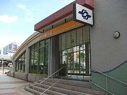
Zhongshan Elementary School MRT station
Zhongshan Elementary School O10 中山國小 | |
|---|---|
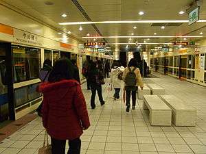 Zhongshan Elementary School station platform | |
| Other names | Qingguang Commercial Zone; 晴光商圈 |
| Location |
B1, No. 71, Sec. 1, Minquan E. Rd. Zhongshan, Taipei Taiwan |
| Operated by | |
| Line(s) |
|
| Connections | Bus stop |
| Construction | |
| Structure type | Underground |
| Platform levels | 3 |
| History | |
| Opened | 3 November 2010 |
| Traffic | |
| Passengers |
31,541 daily (2016)[1] (Ranked 48th of 109) |
| Zhongshan Elementary School MRT station | |||||||||||||
| Traditional Chinese | 中山國小站 | ||||||||||||
|---|---|---|---|---|---|---|---|---|---|---|---|---|---|
| Simplified Chinese | 中山国小站 | ||||||||||||
| |||||||||||||
The Taipei Metro Zhongshan Elementary School station is a station on the Xinzhuang Line located in Zhongshan, Taipei, Taiwan. The station opened for service on 3 November 2010.
This station was named after the Zhongshan Elementary School, but it is notable that Taiwan Institute of Economic Research had their businesses there.
Station overview
This two-level, underground station has an island platform.[2] It is located beneath the intersection of Minquan West Rd. and Linsen North Rd. and opened on 3 November 2010 with the opening of the Luzhou Branch Line and the Taipei City section of the Xinzhuang Line.[3][4]
Construction
Excavation depth for this station is around 19 meters. It is 160 meters in length and 23 meters wide. It has four entrances, one accessible elevator, and two vent shafts.[3] It is equipped with platform screen doors.
| Preceding station | Following station | |||
|---|---|---|---|---|
| Minquan West Road | Zhonghe–Xinlu line | Xingtian Temple towards Nanshijiao | ||
References
| Wikimedia Commons has media related to Zhongshan Elementary School Station. |
- ↑ "Passenger Volume at Taipei Rapid Transit Stations" (PDF). Taipei City Department of Transportation. 2017-03-13. Retrieved 2017-03-13.
- ↑ "Zhongshan Elementary School Station". Taipei Rapid Transit System. Archived from the original on 20 March 2012. Retrieved 2010-11-03.
- 1 2 "Introduction to Xinzhuang MRT Line" (PDF). Department of Rapid Transis Systems. 2008-03-01. Retrieved 2010-06-17.
- ↑ "Second Stage of Taipei MRT (Approved MRT Lines)". Department of Rapid Transit Systems, TCG. 2010-03-12. Retrieved 2010-06-17.
| Stations |
| ||||||
|---|---|---|---|---|---|---|---|
| Rolling stock |
| ||||||
Coordinates: 25°03′46″N 121°31′36″E / 25.062689°N 121.526572°E