Metropolitan Borough of Holborn
| Holborn | |
|---|---|
 Holborn Town Hall | |
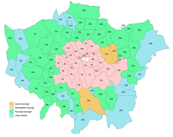
 Holborn within the County of London | |
| Area | |
| • 1911 | 405 acres (1.64 km2) |
| • 1931 | 406 acres (1.64 km2) |
| • 1961 | 407 acres (1.65 km2) |
| Population | |
| • 1911 | 49,357 |
| • 1931 | 38,860 |
| • 1961 | 22,008 |
| Density | |
| • 1911 | 121/acre |
| • 1931 | 96/acre |
| • 1961 | 54/acre |
| History | |
| • Created | 1900 |
| • Abolished | 1965 |
| • Succeeded by | London Borough of Camden |
| Status | Metropolitan borough |
| Government | Holborn Borough Council |
| • HQ | High Holborn |
| • Motto |
Multi Pertransibunt et Augebitur Scientia (Many shall pass through and learning shall be increased) |
 Coat of arms of the borough council | |
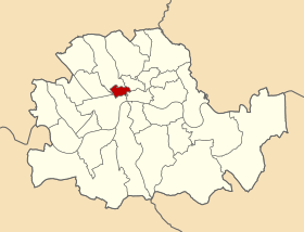
The Metropolitan Borough of Holborn was a metropolitan borough in the County of London between 1900 and 1965, when it was amalgamated with the Metropolitan Borough of St Pancras and the Metropolitan Borough of Hampstead to form the London Borough of Camden.
Formation and boundaries
The borough was formed from seven civil parishes and extra-parochial places: Furnival's Inn (part), Gray's Inn, Liberty of Saffron Hill, Lincoln's Inn, St Andrew Holborn Above the Bars with St George the Martyr, St Giles in the Fields and St George Bloomsbury and Staple Inn. In 1930 these seven were combined into a single civil parish called Holborn, which was conterminous with the metropolitan borough.[1]
Previous to the borough's formation it had been administered by two separate local bodies: Holborn District Board of Works and St Giles District Board of Works. The Inns of Court and Inns of Chancery had not been under the control of any local authority prior to 1900.
Coat of arms
St Giles, St George and St Andrew were depicted on the borough seal. The several constituent parishes were illustrated in the arms granted to Holborn in 1906, while the supporters, the Lion and the Griffin are from the arms of Lincoln's Inn and Gray's Inn (Inns of Court).
Charges from these arms were used, together with charges from the coats of arms of Hampstead and of St. Pancras, when the new coat of arms of the London Borough of Camden was designed in 1965.
Visible legacy
Several of the street name signs in the British Museum/Senate House area still bear the "Borough of Holborn" area designation.
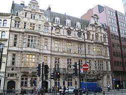
Holborn Town Hall still exists, on High Holborn. The four-storey frontage is in three parts: the easternmost section was built as a Public Library in 1894 by architect W. Rushworth. Then the central and western sections were added in 1906-8 (architects: Hall & Warwick) to form a symmetrical facade.
Population and area
Holborn was the smallest of the twenty-eight metropolitan boroughs of the County of London, with an area of between 405 and 407 acres (1.6 km2). Therefore, it was even smaller than the City of London. It also had the smallest population of any of the boroughs throughout its existence. The populations recorded in National Censuses were:
Constituent parishes 1801–1899
| Year[2] | 1801 | 1811 | 1821 | 1831 | 1841 | 1851 | 1861 | 1871 | 1881 | 1891 |
|---|---|---|---|---|---|---|---|---|---|---|
| Population | 67,103 | 80,642 | 88,172 | 90,670 | 93,767 | 95,726 | 94,074 | 93,513 | 78,668 | 70,938 |
Metropolitan Borough 1900-1961
| Year[3] | 1901 | 1911 | 1921 | 1931 | 1941 | 1951 | 1961 |
|---|---|---|---|---|---|---|---|
| Population | 59,405 | 49,357 | 43,192 | 38,860 | [4] | 24,810 | 22,008 |
Politics
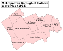
The borough was divided into nine wards for elections: Central St Giles, Lincoln's Inn, North Bloomsbury, North St Andrew, North St Giles, Saffron Hill, South Bloomsbury, South East St Andrew and St George the Martyr.[5][6]
Parliament constituency
For elections to Parliament, the borough was represented by one constituency:
In 1950 the borough's representation was reduced to half a seat, when it was merged with part of St Pancras:
Gallery
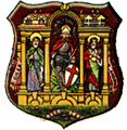 Borough seal
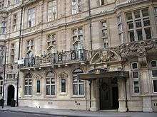 Town Hall frontage
See also
References
- ↑ GB Historical GIS / University of Portsmouth, Holborn CP through time | Census tables with data for the Parish-level Unit, A Vision of Britain through Time. http://www.visionofbritain.org.uk/unit/10234116 Date accessed: 19th February 2015
- ↑ Statistical Abstract for London, 1901 (Vol. IV); Census tables for Holborn Metropolitan Borough
- ↑ Holborn MetB: Census Tables at Vision of Britain accessed 14 Dec 2006
- ↑ The census was suspended for World War II
- ↑ Post Office London County Suburbs Directory, 1919. 1919. Retrieved 18 February 2015.
- ↑ Ordnance Survey 'County Series 3rd Edition' Map of London (1912-14) at 1:2500 scale. Accessed at https://www.old-maps.co.uk/
Further reading
- Robert Donald, ed. (1907). "London: Holborn". Municipal Year Book of the United Kingdom for 1907. London: Edward Lloyd.
Local government districts abolished or transferred by the London Government Act 1963 | ||
|---|---|---|
| London | ||
| Essex | ||
| Hertfordshire | ||
| Middlesex, CC | ||
| Kent | ||
| Surrey | ||
| Transfers | Middlesex to Hertfordshire: Potters Bar
| |
History of the formation of the London Borough of Camden | ||
|---|---|---|
| Metropolitan boroughs | 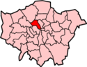 | |
| District boards | ||
| Parishes | ||