Metropolitan Borough of Wandsworth
| Wandsworth | |
|---|---|
 Wandsworth Town Hall | |
 Wandsworth within the County of London | |
| History | |
| • Origin | Wandsworth District Board of Works |
| • Created | 1900 |
| • Abolished | 1965 |
| • Succeeded by |
London Borough of Wandsworth London Borough of Lambeth |
| Status | Metropolitan borough |
| Government | Wandsworth Borough Council |
| • HQ | Town Hall, Wandsworth High Street |
| • Motto | We Serve |
 Coat of arms of the borough council | |
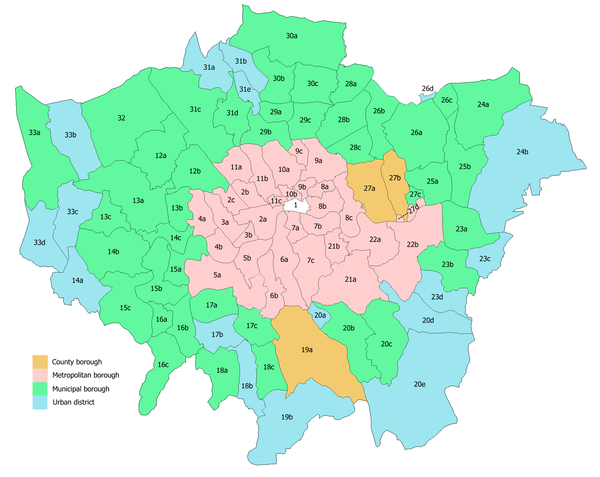
The Metropolitan Borough of Wandsworth was a Metropolitan borough under the London County Council, from 1900 to 1965.
History
The borough was formed from five civil parishes: Clapham, Putney, Streatham, Tooting Graveney and Wandsworth. In 1904 these five were combined into a single civil parish called Wandsworth Borough, which was conterminous with the metropolitan borough.[1] Before 1900 these parishes, and Battersea until 1888, had been administered by the Wandsworth District Board of Works.
Coat of arms
The coat of arms were granted on 6 July 1901. The blue wavy division represents the Rivers Wandle and Thames. French Huguenot refugees arrived in the area in 1685, and the blue drops represent the tears of their struggle. The five stars represent the constituent former parishes. At the top is a long boat, with a dragon's head, commemorating 9th century Danish incursions along the river. The borough council's motto was We Serve.[2]
Population and area
The borough covered 9,130 acres (36.9 km2), which made it the largest in the County of London. The population recorded in the Census was:
Constituent parishes 1801–1899
| Year[3] | 1801 | 1811 | 1821 | 1831 | 1841 | 1851 | 1861 | 1871 | 1881 | 1891 |
|---|---|---|---|---|---|---|---|---|---|---|
| Population | 14,283 | 17,963 | 22,726 | 27,779 | 33,238 | 40,204 | 50,803 | 71,044 | 103,172 | 156,942 |
Metropolitan Borough 1900–1961
| Year[4] | 1901 | 1911 | 1921 | 1931 | 1941 | 1951 | 1961 |
|---|---|---|---|---|---|---|---|
| Population | 232,024 | 311,360 | 328,307 | 353,110 | [5] | 330,493 | 347,442 |
Politics
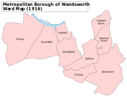
The borough was divided into nine wards for elections: Balham, Clapham North, Clapham South, Fairfield, Putney, Southfield, Springfield, Streatham and Tooting.[6][7]
Parliament constituency
For elections to Parliament, the borough was divided into one and a half constituencies:
In 1918 the borough's representation was increased to five seats:
In 1950 the borough's representation was reduced to four seats:
Replacement
When the metropolitan boroughs were replaced with larger London boroughs in 1965, this borough was split. The core area of Wandsworth (about 11 km2 or 4.2 sq mi) became part of the London Borough of Wandsworth, along with the former Metropolitan Borough of Battersea, but the areas of Streatham and Clapham (totalling 4 km2 or 1.5 sq mi) became part of the London Borough of Lambeth.
References
- ↑ GB Historical GIS / University of Portsmouth, Wandsworth Borough CP through time | Census tables with data for the Parish-level Unit, A Vision of Britain through Time. http://www.visionofbritain.org.uk/unit/10235522 Date accessed: 19th February 2015
- ↑ London County Council (Civic Heraldry) accessed 15 Jan 2008
- ↑ Statistical Abstract for London, 1901 (Vol. IV); Census tables for Metropolitan Borough of Battersea
- ↑ GB Historical GIS / University of Portsmouth, Wandsworth MetB through time | Population Statistics | Total Population, A Vision of Britain through Time. http://www.visionofbritain.org.uk/unit/10135163/cube/TOT_POP Date accessed: 19th February 2015
- ↑ The census was suspended for World War II
- ↑ Post Office London County Suburbs Directory, 1919. 1919. Retrieved 18 February 2015.
- ↑ Ordnance Survey 'County Series 3rd Edition' Map of London (1912-14) at 1:2500 scale. Accessed at https://www.old-maps.co.uk/
Further reading
- Robert Donald, ed. (1907). "London: Wandsworth". Municipal Year Book of the United Kingdom for 1907. London: Edward Lloyd.
Local government districts abolished or transferred by the London Government Act 1963 | ||
|---|---|---|
| London | ||
| Essex | ||
| Hertfordshire | ||
| Middlesex, CC | ||
| Kent | ||
| Surrey | ||
| Transfers | Middlesex to Hertfordshire: Potters Bar
| |