Metropolitan Borough of Southwark
| Southwark | |
|---|---|
| Metropolitan borough | |
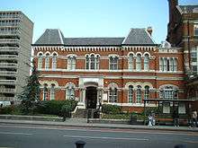 Metropolitan Borough of Southwark Town Hall (previously the Vestry Hall of St Mary, Newington) | |
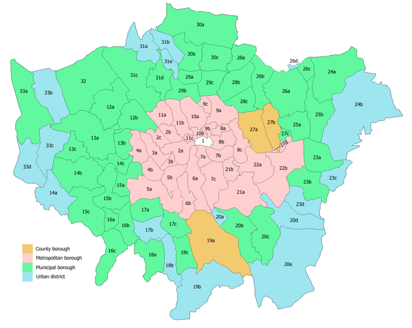
 Southwark within the County of London | |
| Area | |
| • 1911/1931 | 1,132 acres (4.58 km2) |
| • 1961 | 1,131 acres (4.58 km2) |
| Population | |
| • 1911 | 191,907 |
| • 1931 | 171,695 |
| • 1961 | 86,249 |
| Density | |
| • 1911 | 169/acre |
| • 1931 | 152/acre |
| • 1961 | 76/acre |
| History | |
| • Created | 1900 |
| • Abolished | 1965 |
| • Succeeded by | London Borough of Southwark |
| Status | Metropolitan borough |
| Government | Southwark Borough Council |
| • HQ | Town Hall, Walworth Road |
| • Motto | United to serve |
 Coat of arms of the borough council | |
The Metropolitan Borough of Southwark (Br [ˈsʌðɨk])[1] was a metropolitan borough in the County of London from 1900 to 1965. It was created to cover the western section of the ancient borough of Southwark and formed the northwestern part of the current London Borough of Southwark. In common with the rest of inner London, the borough experienced a steady decline in population throughout its existence. The borough council made an unsuccessful attempt to gain city status in 1955.
Formation and boundaries
The borough was formed from four civil parishes: St Mary Newington, Southwark Christchurch, Southwark St George the Martyr and Southwark St Saviour. In 1930 these four were combined into a single civil parish called Southwark, which was conterminous with the metropolitan borough.[2]
Previous to the borough's formation it had been administered by three separate local bodies: St Saviours District Board of Works, Newington Vestry and Southwark St George the Martyr Vestry.
The borough was one of two created in the Southwark area by the London Government Act 1899. The remaining, eastern, part of Southwark (the parishes of St John Horsleydown and St Olave & St Thomas) was combined with Bermondsey and Rotherhithe.[3]
The existing boundaries were found to be "very unsatisfactory". Accordingly they were realigned, for the most part following the centre of roads. Guy's Hospital, which had been divided between three parishes, was entirely taken into the borough.[4]
History
Naming issues
The legislation did not name the two boroughs. Instead this responsibility was given to the commissioners who were appointed under the act to simplify the boundaries between the new municipalities. Representatives for the various vestries gave their suggestions: St Saviour's District Board suggested "Southwark" for the western borough, denying that the eastern borough had a "co-equal" claim to the name. Representatives of the Collegiate Church of St Saviour supported the district board. It was pointed out that a new diocese was soon to be established with the collegiate church becoming the cathedral. This, it was reasoned, would make the new borough the "City of Southwark".[5]
Newington Vestry believed that the borough should bear their name as they were the "predominant partner" in the merger in terms of population, acreage, rateable value and municipal property, and that the council was likely to be based in their district. The name "Walworth" was also proposed as the area had Roman associations and also appeared in early written histories.[5]
The commissioners originally suggested that "West Southwark" might be acceptable, with the neighbouring borough bearing the name "East Southwark". The vestry of St John Horsleydown proposed naming the boroughs as "Southwark St Saviour's" and "Southwark St Olave's", a suggestion supported by the London County Council.[5] A decision was finally made on 25 January 1900, with the western borough becoming "Southwark" and the eastern borough as Bermondsey.[6]
In 1955 the borough council unsuccessfully petitioned for the grant of city status.[7]
Districts
It included the areas now known as:
Abolition
The London Government Act 1963 abolished both the County of London and the metropolitan boroughs. In their place were created Greater London, which was divided into 32 London Boroughs, formed by the merger of existing authorities. On 1 April 1965 the London Borough of Southwark was formed by the amalgamation of the three metropolitan boroughs of Southwark, Camberwell and Bermondsey.[3]
Population and area
The Borough had an area of 1,131 acres (4.6 km2). The population from the Census was:
Constituent parishes 1801–1899
| Year[8] | 1801 | 1811 | 1821 | 1831 | 1841 | 1851 | 1861 | 1871 | 1881 | 1891 |
|---|---|---|---|---|---|---|---|---|---|---|
| Population | 62,669 | 78,219 | 99,562 | 116,006 | 134,225 | 152,371 | 173,900 | 175,049 | 195,164 | 202,693 |
Metropolitan Borough 1900–1961
| Year[9] | 1901 | 1911 | 1921 | 1931 | 1941 | 1951 | 1961 |
|---|---|---|---|---|---|---|---|
| Population | 206,160 | 191,907 | 184,404 | 171,695 | [10] | 97,221 | 86,249 |
Politics

The borough was divided into ten wards for elections: Christchurch, St George's, St John's, St Jude's, St Mary's, St Michael's, St Paul's, St Peter's, St Saviour and Trinity.[11][12]
Parliament constituency
For elections to Parliament, the borough was divided into three constituencies:
In 1918 the boundaries of the borough's three seats were adjusted and all three were renamed:
In 1950 the borough's representation was reduced to one seat:
References
- ↑ "Southwark", in The Columbia Lippincott Gazetteer of the World (1952), New York: Columbia University Press.
- ↑ GB Historical GIS / University of Portsmouth, Southwark CP through time | Census tables with data for the Parish-level Unit, A Vision of Britain through Time. http://www.visionofbritain.org.uk/unit/10233434 Date accessed: 19th February 2015
- 1 2 Youngs, Frederic A, Jr. (1979). Guide to the Local Administrative Units of England, Vol.I: Southern England. London: Royal Historical Society. p. 645. ISBN 0-901050-67-9.
- ↑ "The New London Boroughs". The Times. 30 November 1899. p. 12.
- 1 2 3 "The New London Boroughs". The Times. 1 December 1899. p. 12.
- ↑ "The New London Boroughs". The Times. 26 January 1900. p. 11.
- ↑ J V Beckett, City Status in the British Isles 1830 - 2002, London, 2005
- ↑ Statistical Abstract for London, 1901 (Vol. IV); Census tables for Metropolitan Borough of Southwark
- ↑ GB Historical GIS / University of Portsmouth, Southwark MetB through time | Population Statistics | Total Population, A Vision of Britain through Time. http://www.visionofbritain.org.uk/unit/10133610/cube/TOT_POP Date accessed: 19th February 2015
- ↑ The census was suspended for World War II
- ↑ Post Office London County Suburbs Directory, 1919. 1919. Retrieved 18 February 2015.
- ↑ Ordnance Survey 'County Series 3rd Edition' Map of London (1912-14) at 1:2500 scale. Accessed at https://www.old-maps.co.uk/
Further reading
- Robert Donald, ed. (1907). "London: Southwark". Municipal Year Book of the United Kingdom for 1907. London: Edward Lloyd.
Local government districts abolished or transferred by the London Government Act 1963 | ||
|---|---|---|
| London | ||
| Essex | ||
| Hertfordshire | ||
| Middlesex, CC | ||
| Kent | ||
| Surrey | ||
| Transfers | Middlesex to Hertfordshire: Potters Bar
| |