Saffron Hill, Hatton Garden, Ely Rents and Ely Place
The Liberty of Saffron Hill, Hatton Garden, Ely Rents and Ely Place became a civil parish in the metropolitan area of London, England between 1866 and 1930.[1] It was part of the ancient parish of St Andrew Holborn.
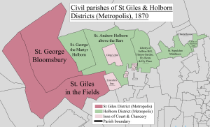
The liberty's southern boundary was the street now called Holborn, its western boundary was Leather Lane and it stretched north of Clerkenwell Road between Back Hill and Herbal Hill to the junction of Warner Street and Ray Street. The boundary in the east approximated to Farringdon Road and Farringdon Street and it included the entire lengths of the streets now called Saffron Hill, Hatton Garden and Ely Place. Ely Rents was a group of houses owned by the See of Ely.[2]
The liberty had a workhouse from 1730 and was included in the Holborn Poor Law Union in 1836.[3]
The liberty occupied an area of 30 acres and its population was as follows:[4]
| Year | 1801 | 1811 | 1821 | 1831 | 1841 | 1851 | 1881 | 1891 | 1901 | 1911 | 1921 |
|---|---|---|---|---|---|---|---|---|---|---|---|
| Population | 7,781 | 7,482 | 9,270 | 9,745 | 9,455 | 8,728 | 3,980 | 4,506 | 2,561 | 1,733 | 825 |
For local government it was grouped into the Holborn District from 1855 to 1900 and then became part of the Metropolitan Borough of Holborn. The civil parish was abolished in 1930.
References
- ↑ "Liberty of Saffron Hill Hatton Garden Ely Rents and Ely Place CP/ParLib through time - Census tables with data for the Parish-level Unit". visionofbritain.org.uk.
- ↑ "Victorian London - Publications - Social Investigation/Journalism - The Rookeries of London, by Thomas Beames, 1852 - Chapter 4". victorianlondon.org.
- ↑ "The Workhouse". workhouses.org.uk.
- ↑ "Liberty of Saffron Hill Hatton Garden Ely Rents and Ely Place CP/ParLib through time - Population Statistics - Total Population". visionofbritain.org.uk.
History of the formation of the London Borough of Camden | ||
|---|---|---|
| Metropolitan boroughs |  | |
| District boards | ||
| Parishes | ||