Municipal Borough of Sutton and Cheam
| Sutton and Cheam (Sutton from 1882 to 1928) | |
|---|---|
| Area | |
| • 1891 | 1,836 acres (7.43 km2) |
| • 1931 | 3,744 acres (15.15 km2) |
| • 1961 | 4,338 acres (17.56 km2) |
| Population | |
| • 1891 | 10,334 |
| • 1931 | 46,500 |
| • 1961 | 79,008 |
| Density | |
| • 1891 | 5.6/acre |
| • 1931 | 12.4/acre |
| • 1961 | 18.2/acre |
| History | |
| • Origin | Sutton parish |
| • Created | 1882 |
| • Abolished | 1965 |
| • Succeeded by | London Borough of Sutton |
| Status |
local government district (1882—1894) urban district (1894—1934) municipal borough (1934—1965) civil parish (1949—1965) |
| • Motto | Serve God and Be Cheerful |
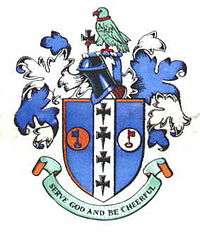 Coat of arms | |
| Subdivisions | |
| • Type | Civil parish |
| • Units |
Sutton (1882—1949) Cheam (1928—1949) |
Sutton and Cheam was a local government district in north east Surrey, England from 1882 to 1965.
Sutton Local Government District was formed on 20 December 1882, when the parish of Sutton adopted the Local Government Act 1858. Sutton Local Board was formed to govern the area.[1]
The Local Government Act 1894 reconstituted the local government district as Sutton Urban District and an urban district council replaced the local board.
In 1928 the urban district was expanded to take in the parish of Cheam from the neighbouring Epsom Rural District to become Sutton and Cheam Urban District.[2] It was expanded slightly in 1933 when a county review order abolished Epsom Rural District. The urban district council successfully petitioned for a charter of incorporation and the town became a municipal borough in 1934.[2] Charter Day was celebrated on 12 September 1934 with local festivities, including a quarter peal on the bells of All Saints, Benhilton.[3]
The borough was granted a coat of arms on incorporation. The shield represented the ancient ecclesiastical landowners of the area. The crosses came from the arms of the Archdiocese of Canterbury, the manor of Cheam having been granted to Christchurch, Canterbury in 1018. The keys of St Peter came from the arms of Chertsey Abbey who held Sutton at the time of the Domesday Book. The crest above the shield was a popinjay (parrot) from the arms of the Lumley family. The motto was that of Bishop John Hacket, rector of Cheam from 1624 - 1662.[4]
In 1965, under the London Government Act 1963, the borough was abolished and its former area was transferred to Greater London, along with the Carshalton Urban District and the Municipal Borough of Beddington and Wallington, to form the present-day London Borough of Sutton.
| Year | 1881 | 1891 | 1901 | 1911 | 1921 | 1931 | 1939 | 1951 | 1961 |
|---|---|---|---|---|---|---|---|---|---|
| Population[5][6] | 10,334 | 13,977 | 17,223 | 21,270 | 21,063 | 46,500 | 73,593 | 80,673 | 79,008 |
References
- ↑ Kelly's Directory of Kent, Surrey & Sussex, 1891, p.1503 (Historical Directories), accessed 5 February 2008
- 1 2 Frederic A Youngs Jr., A Guide to the Local Administrative Units of England, Vol I: Southern England, London, 1979
- ↑ "Sutton Charter Day Ringing". The Ringing World. 21 September 1934. p. 602.
- ↑ C W Scott-Giles, Civic Heraldry of England and Wales, 2nd edition, London, 1953
- ↑ http://www.visionofbritain.org.uk/data_cube_page.jsp?data_theme=T_POP&data_cube=N_TOT_POP&u_id=10147517&c_id=10001043&add=N
- ↑ http://www.visionofbritain.org.uk/data_cube_page.jsp?data_theme=T_POP&data_cube=N_TOT_POP&u_id=10213502&c_id=10001043&add=N
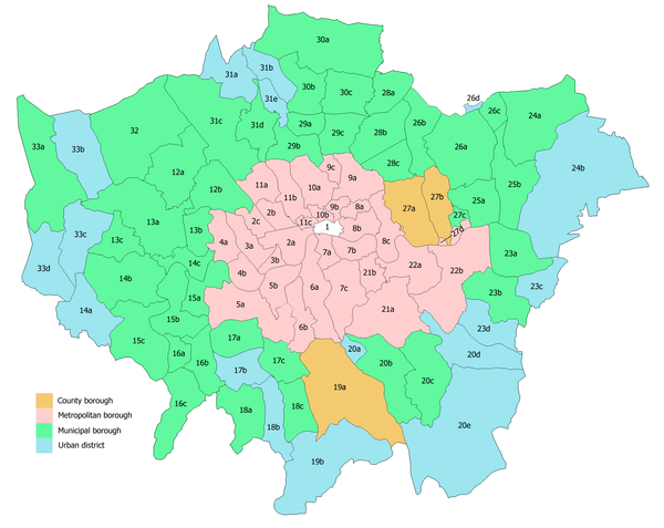
Local government districts abolished or transferred by the London Government Act 1963 | ||
|---|---|---|
| London | ||
| Essex | ||
| Hertfordshire | ||
| Middlesex, CC | ||
| Kent | ||
| Surrey | ||
| Transfers | Middlesex to Hertfordshire: Potters Bar
| |