McNab/Braeside
| McNab/Braeside | |
|---|---|
| Township (lower-tier) | |
| Township of McNab/Braeside | |
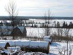 Countryside near Braeside | |
| Motto(s): "Fair Is The Land, Strong The People" | |
 McNab/Braeside | |
| Coordinates: 45°27′N 76°30′W / 45.450°N 76.500°WCoordinates: 45°27′N 76°30′W / 45.450°N 76.500°W | |
| Country |
|
| Province |
|
| County | Renfrew |
| Incorporation | January 1, 1998 |
| Government | |
| • Type | Township |
| • Mayor | Tom Peckett |
| Area[1] | |
| • Land | 255.74 km2 (98.74 sq mi) |
| Population (2011)[1] | |
| • Total | 7,371 |
| • Density | 28.8/km2 (75/sq mi) |
| Time zone | UTC−5 (EST) |
| • Summer (DST) | UTC−4 (EDT) |
| Area code(s) | 613, 343 |
| Website |
www |
McNab/Braeside is a township in eastern Ontario, Canada, on the south shore of Chats Lake (part of the Ottawa River), straddling the lower Madawaska River in Renfrew County.
The township was created on January 1, 1998, when the Village of Braeside amalgamated with McNab Township.
Mayor Tom Peckett was elected in October 2014.[2]
History
McNab township was created in 1825, comprising roughly 80,000 acres of unsettled land, covering the current Town of Arnprior and Township of McNab/Braeside. It was granted by the government ("Family Compact") to Archibald 13th Laird of McNab (1779-1860), who had fled from his debts in Scotland. He promised to settle it with Highland clansmen, and the first group of eighty-four settlers arrived the same year, 1825. McNab ruled with an iron fist over the Scottish settlers. Only after eighteen years of petitions, court battles, and appeals was his grip loosened when the government finally began issuing Crown grants to the settlers. His feudal powers removed, the Laird eventually sold his lands to the government and returned to Europe in 1852, never to return.
Braeside was named in 1872 by W.J. McDonald probably for Braeside, Greenock in Inverclyde, Scotland.[3]
Communities
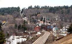
- Braeside
- Burnstown
- Clay Bank
- Clay Valley
- Dewars
- Glasgow Station
- Goshen
- Lochwinnoch
- Lundys Corners
- Pinegrove
- Sand Point
- Stewartville
- Waba
- White Lake
Mayors
Demographics
| Canada census – McNab/Braeside community profile | |||
|---|---|---|---|
| 2011 | 2006 | ||
| Population: | 7371 (2.1% from 2006) | 7222 (5.5% from 2001) | |
| Land area: | 255.74 km2 (98.74 sq mi) | 253.87 km2 (98.02 sq mi) | |
| Population density: | 28.8/km2 (75/sq mi) | 28.4/km2 (74/sq mi) | |
| Median age: | 42.3 (M: 42.2, F: 42.5) | ||
| Total private dwellings: | 3061 | 2934 | |
| Median household income: | $66,049 | ||
| References: 2011[4] 2006[5] earlier[6] | |||
- Population in 2011: 7371
- Population in 2006: 7222
- Population in 2001: 6843
- Population in 1996:
- McNab (township): 5765
- Braeside (village): 715
- Population in 1991:
- McNab (township): 5464
- Braeside (village): 562
See also
External links
References
- 1 2 3 "McNab/Braeside census profile". 2011 Census of Population. Statistics Canada. Retrieved 2012-02-10.
- 1 2 3 Carter, John (2014-10-27). "McNab-Braeside council ousted". Arnprior Chronicle-Guide. Retrieved 2015-02-15.
- ↑ Rayburn, Alan (1997). Place names of Ontario. Toronto: University of Toronto Press. p. 41. ISBN 0-8020-7207-0. Retrieved 13 October 2017.
- ↑ "2011 Community Profiles". Canada 2011 Census. Statistics Canada. July 5, 2013. Retrieved 2012-02-10.
- 1 2 "2006 Community Profiles". Canada 2006 Census. Statistics Canada. March 30, 2011. Retrieved 2012-02-10.
- 1 2 "2001 Community Profiles". Canada 2001 Census. Statistics Canada. February 17, 2012.
- ↑ Statistics Canada: 1996 census
Places adjacent to McNab/Braeside | |
|---|---|
| Cities |  | |
|---|---|---|
| Towns | ||
| Townships | ||
| First Nations | ||
| Indian reserves | ||
| ||