Head, Clara and Maria
| Head, Clara and Maria | |
|---|---|
| Township (lower-tier) | |
| United Townships of Head, Clara and Maria | |
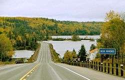 Highway 17 and Ottawa River at Deux-Rivières | |
 Head, Clara and Maria | |
| Coordinates: 46°10′N 78°00′W / 46.167°N 78.000°WCoordinates: 46°10′N 78°00′W / 46.167°N 78.000°W | |
| Country |
|
| Province |
|
| County | Renfrew |
| Incorporated | 1878 |
| Government | |
| • Mayor | Robert Reid |
| Area | |
| • Total | 728.15 km2 (281.14 sq mi) |
| Population (2011)[1] | |
| • Total | 235 |
| • Density | 0.3/km2 (0.8/sq mi) |
| Time zone | UTC-5 (EST) |
| • Summer (DST) | UTC-4 (EDT) |
| Postal code span | Deux Rivières - K0J 1R0; Bissett Creek - K0J 1E0; Stonecliffe - K0J 2K0; Mackey - K0J 2B0; |
| Area code(s) | 613 705 |
| Website |
www.townshipsof headclaramaria.ca |
Head, Clara and Maria, officially the United Townships of Head, Clara and Maria, is a municipality and incorporated township in Renfrew County in eastern Ontario, Canada, It is on the Ottawa River and on the northern edge of Algonquin Park.
Virtually all the communities (Deux-Rivières, Bissett Creek, Stonecliffe and Mackey) and activities are along Highway 17, the rest of the township is largely crown land which is mostly wilderness. Head, Clara and Maria is bordered on the north by the Ottawa River and on the south by Algonquin Provincial Park. Trans Canada Highway 17 runs through the four hamlets which make up this municipality. The municipality is a remarkable cottage destination with many provincial land use permits allowing cottages on crown land. Property taxes are the lowest in Renfrew County.
History
The township of Head was named in honour of Sir Edmund Walker Head, 8th Baronet who served as Lieutenant-Governor of New Brunswick 1847-1854 and Governor-General of Canada 1854-1861. The township of Maria was named in honour of his wife, Lady Anna Maria Head (Nee Yorke) (1808-1890).[2]
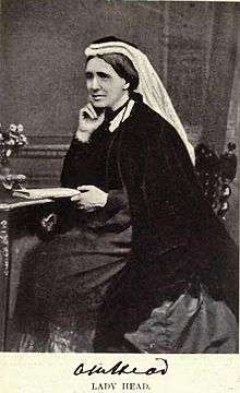 Lady Anna Maria Head (née Yorke)
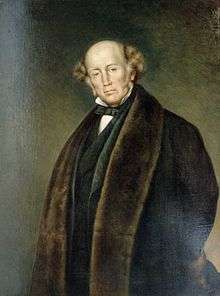
Communities
.jpg)
The township includes the communities of Aylen,[3] Bissett Creek, Deux-Rivières, Mackey and Stonecliffe. The municipal offices are located in Stonecliffe.
Deux-Rivières is home to Antlers King Fisher Lodge and access to Algonquin Park via the Brent Road. Stonecliffe is home to Yates General Store, Morning Mist Resort, Pine Valley Lodge, Driftwood Provincial Park and the Municipal Office. Mackey is home to Lakeview Trailer Park.
Demographics
According to the Canada 2011 Census:[1]
- Population: 235
- % Change (2006-2011): 3.1
- Dwellings: 128
- Area (km².): 728.15
- Density (persons per km².): 0.3
Notable people
- Michael James Heney, a railroad contractor of international renown, best known for his work on the first two railroads built in Alaska, the White Pass and Yukon Route and the Copper River and Northwestern Railway, was born in Stonecliffe.
See also
References
- 1 2 "2011 Census Profile".
- ↑ Morgan, Henry James, ed. (1903). Types of Canadian Women and of Women who are or have been Connected with Canada. Toronto: Williams Briggs. p. 153.
- ↑ "Aylen". Geographical Names Data Base. Natural Resources Canada. Retrieved 2018-08-31.
External links
Places adjacent to Head, Clara and Maria | |
|---|---|
| Cities | 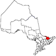 | |
|---|---|---|
| Towns | ||
| Townships | ||
| First Nations | ||
| Indian reserves | ||
| ||