Clarendon, Quebec
| Clarendon | |
|---|---|
| Municipality | |
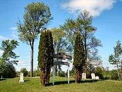 Historic cemetery on Front Road | |
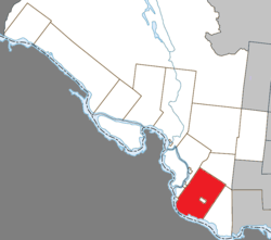 Location within Pontiac RCM. | |
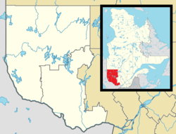 Clarendon Location in western Quebec. | |
| Coordinates: 45°39′N 76°31′W / 45.650°N 76.517°WCoordinates: 45°39′N 76°31′W / 45.650°N 76.517°W[1] | |
| Country |
|
| Province |
|
| Region | Outaouais |
| RCM | Pontiac |
| Constituted | July 1, 1855 |
| Government[2] | |
| • Mayor | John Armstrong |
| • Federal riding | Pontiac |
| • Prov. riding | Pontiac |
| Area[2][3] | |
| • Total | 348.40 km2 (134.52 sq mi) |
| • Land | 334.53 km2 (129.16 sq mi) |
| Elevation | 167 m (548 ft) |
| Population (2011)[3] | |
| • Total | 1,183 |
| • Density | 3.5/km2 (9/sq mi) |
| • Pop 2006-2011 |
|
| • Dwellings | 806 |
| Time zone | UTC−5 (EST) |
| • Summer (DST) | UTC−4 (EDT) |
| Postal code(s) | J0X 2Y0 |
| Area code(s) | 819 |
| Highways |
|
Clarendon is a municipality in the Outaouais region, part of the Pontiac Regional County Municipality, Quebec, Canada. It is located on the north shore of the Ottawa River across from Horton Township in Ontario.
Its settlements include Clarendon, North Clarendon, Charteris, Lawn, Murrell, Radford, Sand Bay, Starks Corners, and Yarm. The town of Shawville is surrounded by, but not part of, Clarendon.[4]
Largely cleared of forests, Clarendon is a predominantly agricultural municipality, with an elevation of 167 meters (548 ft) above sea level. The only notable lake is Green Lake, which is surrounded by cottages.[4]
History
The township was first surveyed in 1792 and appears on the Gale and Duberger map of 1795.[4] Settlement did not occur until 1825 when James Prendergast, a retired British Army Officer, was commissioned by the government to lead this task. From that year until 1827, free land was granted, resulting in a wave of settlers, starting with 15 settlers near the township's centre (now Shawville). But Prendergast, originally from religiously-divided Ireland, stipulated that settlers only be Protestants in order to avoid similar religious strife. As a result, Clarendon (and Shawville) is known as the heartland of Anglo-Saxon Protestantism in western Quebec.[5]
Between 1827 and 1835, Prendergast was responsible for establishing the first four schools and bringing in its teachers. He also built a water-driven sawmill and grist mill at his home along the Ottawa River.[5]
In 1833, the Township of Clarendon was officially established. It was named after Clarendon Park, near Salisbury in Wiltshire, England (where Henry II had convened peers and bishops to formulate the Constitutions of Clarendon in 1164). In 1837, the post office opened.[6] From then on and into the 1840s, when the timber industry started to prosper, a second wave of settlement occurred, doubling the population of Clarendon between 1840 and 1850.[5]
In 1855, the Township Municipality of Clarendon was created. This style was reformed to Municipality of Clarendon on October 11, 2003.[6]
Demographics
Population
| Canada census – Clarendon, Quebec community profile | |||
|---|---|---|---|
| 2011 | 2006 | ||
| Population: | 1,183 (-5.2% from 2006) | 1,248 (-6.9% from 2001) | |
| Land area: | 334.53 km2 (129.16 sq mi) | 334.27 km2 (129.06 sq mi) | |
| Population density: | 3.5/km2 (9.1/sq mi) | 3.7/km2 (9.6/sq mi) | |
| Median age: | 47.9 (M: 48.2, F: 47.7) | 43.9 (M: 44.1, F: 43.6) | |
| Total private dwellings: | 806 | 738 | |
| Median household income: | $40,187 | $47,283 | |
| References: 2011[3] 2006[7] earlier[8] | |||
| Historical Census Data - Clarendon, Quebec[9] | ||||||||||||||||||||||||||
|---|---|---|---|---|---|---|---|---|---|---|---|---|---|---|---|---|---|---|---|---|---|---|---|---|---|---|
|
|
| ||||||||||||||||||||||||
Language
Languages:[7]
- English as first language: 81%
- French as first language: 19%
See also
References
- ↑ Reference number 379123 of the Commission de toponymie du Québec (in French)
- 1 2 "Clarendon". Répertoire des municipalités (in French). Ministère des Affaires municipales, des Régions et de l'Occupation du territoire. Retrieved 2012-04-02.
- 1 2 3 "2011 Community Profiles". Canada 2011 Census. Statistics Canada. July 5, 2013. Retrieved 2014-02-01.
- 1 2 3 "Canton de Clarendon" (in French). Commission de toponymie du Québec. Retrieved 2008-05-27.
- 1 2 3 "Pontiac MRC Gateway: Clarendon". Pontiac MRC Gateway. Archived from the original on October 7, 2006. Retrieved 2008-05-27.
- 1 2 "Municipalité de Canton de Clarendon" (in French). Commission de toponymie du Québec. Retrieved 2008-05-27.
- 1 2 "2006 Community Profiles". Canada 2006 Census. Statistics Canada. March 30, 2011. Retrieved 2012-04-02.
- ↑ "2001 Community Profiles". Canada 2001 Census. Statistics Canada. February 17, 2012.
- ↑ Statistics Canada: 1996, 2001, 2006, 2011 census
Adjacent Municipal Subdivisions | |
|---|---|
| Municipalities | |
|---|---|
| Townships | |
| Villages | |
| Unorganized territories | |
| |