Renfrew, Ontario
| Renfrew | |
|---|---|
| Town (lower-tier) | |
| Town of Renfrew | |
 Raglan Street in the centre of Renfrew | |
 Renfrew Location of Renfrew in the province of Ontario | |
| Coordinates: 45°28′18″N 76°40′59″W / 45.47167°N 76.68306°WCoordinates: 45°28′18″N 76°40′59″W / 45.47167°N 76.68306°W | |
| Country |
|
| Province |
|
| County | Renfrew |
| Incorporated | July 27, 1858 |
| Government | |
| • Mayor | Don Eady |
| • Reeve | Peter Emon |
| Area[1] | |
| • Land | 12.77 km2 (4.93 sq mi) |
| Population (2016)[1] | |
| • Total | 8,223 |
| • Density | 643.4/km2 (1,666/sq mi) |
| • Dwellings | 4,035 |
| • Pop. Growth (2011-2016) | 0.1% |
| Time zone | UTC-5 (EST) |
| • Summer (DST) | UTC-4 (EDT) |
| Postal code FSA | K7V |
| Area code(s) | 613 & 343 |
| Exchanges | (432, 433, 570 exchange) |
| Highways |
|
| Website | renfrewontario.com renfrewontario.ca |
Renfrew, Ontario, Canada, is a town on the Bonnechere River in Renfrew County. Located one hour west of Ottawa in Eastern Ontario, Renfrew is the third largest town in the county after Petawawa and Pembroke. The town is a small transportation hub connecting Highway 60 and Highway 132 with the Trans-Canada Highway. Renfrew is also known historically for its role in the formation of the National Hockey League. It lies about 5 kilometres from the Quebec border, about 10 kilometres by road.
History
Named after Renfrewshire, Scotland, in approximately 1848,[2] Renfrew was settled largely in part due to logging in the area in the early 19th century, where the river was used in order to drive the lumber to locations such as Ottawa. This heritage was until recently celebrated every July with the Lumber Baron Festival.
Geography
Renfrew and the surrounding Township of Horton are at the intersection of the Bonnechere River and the Ottawa River in the Ottawa Valley. Renfrew is at the intersection of provincial Highway 17, Highway 60, and Highway 132.
Education
Renfrew County District School Board
Primary Schools (Grade K-6)
- Admaston Public School
- Central Public School
- Queen Elizabeth Public School
Middle School (Grade 7-8)
- Renfrew Collegiate Intermediate School
Secondary School (Grade 9-12)
Renfrew County Catholic District School Board
Primary Schools
- St. Thomas The Apostle Catholic School(Grade K-7)
- Our Lady of Fatima Catholic School(Grade K-7)
Secondary School (Grade 8-12)
Climate
Renfrew has a humid continental climate (Köppen Dfb) with four distinct seasons, warm summers, cold snowy winters and no dry season.[3]
| Climate data for Renfrew, Ontario (1971–2000) | |||||||||||||
|---|---|---|---|---|---|---|---|---|---|---|---|---|---|
| Month | Jan | Feb | Mar | Apr | May | Jun | Jul | Aug | Sep | Oct | Nov | Dec | Year |
| Record high °C (°F) | 13.0 (55.4) |
12.0 (53.6) |
23.9 (75) |
31.7 (89.1) |
34.0 (93.2) |
35.0 (95) |
38.3 (100.9) |
37.8 (100) |
33.0 (91.4) |
28.0 (82.4) |
21.1 (70) |
16.0 (60.8) |
38.3 (100.9) |
| Average high °C (°F) | −6.4 (20.5) |
−4.3 (24.3) |
2.2 (36) |
10.0 (50) |
19.0 (66.2) |
23.7 (74.7) |
26.6 (79.9) |
25.2 (77.4) |
19.5 (67.1) |
12.5 (54.5) |
4.6 (40.3) |
−3.3 (26.1) |
10.8 (51.4) |
| Daily mean °C (°F) | −12 (10) |
−10.4 (13.3) |
−3.6 (25.5) |
4.9 (40.8) |
12.2 (54) |
16.9 (62.4) |
19.7 (67.5) |
18.5 (65.3) |
13.4 (56.1) |
7.1 (44.8) |
0.3 (32.5) |
−8.3 (17.1) |
4.9 (40.8) |
| Average low °C (°F) | −17.6 (0.3) |
−16.5 (2.3) |
−9.4 (15.1) |
−1.1 (30) |
5.4 (41.7) |
10.1 (50.2) |
12.8 (55) |
11.8 (53.2) |
7.3 (45.1) |
1.7 (35.1) |
−4 (25) |
−13.2 (8.2) |
−1.1 (30) |
| Record low °C (°F) | −42.5 (−44.5) |
−38 (−36) |
−35 (−31) |
−21 (−6) |
−9 (16) |
−2.5 (27.5) |
0 (32) |
−1.5 (29.3) |
−6 (21) |
−12 (10) |
−29 (−20) |
−38 (−36) |
−42.5 (−44.5) |
| Average precipitation mm (inches) | 60.6 (2.386) |
50.6 (1.992) |
60.5 (2.382) |
67.5 (2.657) |
69.5 (2.736) |
74.9 (2.949) |
77.0 (3.031) |
79.9 (3.146) |
70.0 (2.756) |
72.3 (2.846) |
63.5 (2.5) |
65.3 (2.571) |
811.5 (31.949) |
| Average rainfall mm (inches) | 15.4 (0.606) |
12.2 (0.48) |
32.0 (1.26) |
57.3 (2.256) |
68.5 (2.697) |
74.9 (2.949) |
77.0 (3.031) |
79.9 (3.146) |
70.0 (2.756) |
68.2 (2.685) |
43.9 (1.728) |
16.7 (0.657) |
616 (24.25) |
| Average snowfall cm (inches) | 45.2 (17.8) |
38.4 (15.12) |
28.5 (11.22) |
10.3 (4.06) |
1.0 (0.39) |
0 (0) |
0 (0) |
0 (0) |
0 (0) |
4.1 (1.61) |
19.5 (7.68) |
48.6 (19.13) |
195.5 (76.97) |
| Average precipitation days (≥ 0.2 mm) | 13.7 | 10.1 | 11.0 | 11.9 | 13.5 | 12.9 | 11.8 | 12.7 | 13.7 | 14.0 | 13.3 | 13.1 | 151.7 |
| Average rainy days (≥ 0.2 mm) | 2.4 | 2.0 | 5.4 | 10.0 | 13.4 | 12.9 | 11.8 | 12.7 | 13.7 | 13.3 | 9.4 | 3.4 | 110.4 |
| Average snowy days (≥ 0.2 cm) | 11.9 | 8.7 | 6.7 | 2.4 | 0.19 | 0 | 0 | 0 | 0 | 0.96 | 4.8 | 10.5 | 46.15 |
| Source: Environment Canada[4] | |||||||||||||
Demographics
| Canada census – Renfrew, Ontario community profile | |||
|---|---|---|---|
| 2016 | 2011 | 2006 | |
| Population: | 8223 (0.1% from 2011) | 8218 (4.7% from 2006) | 7846 (-1.2% from 2001) |
| Land area: | 12.78 km2 (4.93 sq mi) | 12.77 km2 (4.93 sq mi) | 12.77 km2 (4.93 sq mi) |
| Population density: | 643.4/km2 (1,666/sq mi) | 643.5/km2 (1,667/sq mi) | 614.4/km2 (1,591/sq mi) |
| Median age: | 48.0 (M: 45.6, F: 50.0) | 45.4 (M: 43.7, F: 46.7) | |
| Total private dwellings: | 4035 | 3980 | 3686 |
| Median household income: | $39,511 | ||
| References: 2016[5] 2011[6] 2006[7] earlier[8] | |||
Population:[9]
| Historical populations | ||
|---|---|---|
| Year | Pop. | ±% |
| 1991 | 8,134 | — |
| 1996 | 8,125 | −0.1% |
| 2001 | 7,942 | −2.3% |
| 2006 | 7,846 | −1.2% |
| 2011 | 8,218 | +4.7% |
| 2016 | 8,223 | +0.1% |
First Language:
- English: 91.8%
- French: 4.0%
- English and French: 0.5%
- Other: 3.7%
Economy

Much of Renfrew's current prosperity can be attributed to its status as an economic centre for a surrounding rural region with a population of over 30,000. Renfrew is also an important stop for Ottawa-based cottagers and outdoor enthusiasts passing by on their way to nearby whitewater rafting, boating, camping, hunting, golfing, fishing, snowmobiling, down-hill skiing, and cross-country skiing. However, the area's largest single employers are the Renfrew Victoria Hospital and the Bonnechere Manor.[11] In addition to numerous small employers, there are also several manufacturing facilities employing several hundred people; Scapa Tapes Renfrew, formerly Renfrew Tape makes products such as hockey tape that is used across North America and the duct tape brand featured on the discontinued Red Green Show and promoted by Doug Gilmour in the early 90's after becoming a member of the Toronto Maple Leafs. Times Fibre Canada and Madawaska Hardwood Flooring also have manufacturing facilities in town. Haley Industries located outside Renfrew near Haley Station is also a major employer in the area. Renfrew is also home to many successful small businesses. Between 2000 and 2005, a major portion of Renfrew's retail business, and the associated customer services jobs, shifted from the west-end Renfrew mall (now demolished) to its east-end industrial park near Highway 17 due to the opening of several major big-box such as No Frills and Walmart and smaller retail stores.
Residents of the area await the twinning of Highway 17 to improve traffic flow and the safety of the highway due to numerous accidents along the corridor to North Bay, Ontario.
Despite the apparent prosperity, Statistics Canada reported the average earnings of Renfrew residents in 2000 as $35,811, or roughly 31% lower than the provincial average and 5% lower than the county average.[12] Further, the town reports, relative to the population size and compared to the province as a whole, fewer positions in management, business, finance, administration and natural or applied sciences, while there was greater than the provincial rates of occupation in sales and service, trades, transport and equipment operators, processing, manufacturing and utilities.[12]
Culture
Hockey
One of the four original teams in the National Hockey Association, the precursor to the NHL, was based in Renfrew. The Renfrew Creamery Kings sought to be allowed to play in the Eastern Canada Amateur Hockey Association, but with no success. The team's owner, M. J. O'Brien, eventually financed and put together his own league, the NHA. The Creamery Kings played two seasons of hockey in the NHA, 1911 and 1912, until M. J. O'Brien pulled out to pursue his interests in the railway.[13]
Media
- Renfrew Mercury (external link)
- My FM (external link)
- TVCogeco
- CJHR-FM 98.7, Valley Heritage Radio (external link)
The O'Brien Theatre was a balconied and elegantly decorated town landmark that was converted from a live theatre to a movie theatre, then upgraded in the 1990s to accommodate two screens, but maintains much of the original appeal.
Festivals
- Renfrew was the annual host and sponsor of the Ottawa Valley Lumber Baron Festival, a celebration of the town's roots in the logging industry. The Lumber Baron Festival is now known as Valleyfest, dropping its historical roots.
- The Renfrew Fair has been drawing mixed crowds for decades with its mid-way rides, exhibits, demolition derby, musical acts and livestock showcase. The fair takes place on the second weekend of every September and lasts from Wednesday afternoon through Sunday afternoon. The rides are supplied by the company Carter Shows.
- There is a nearby Blue Grass music festival that takes place every year in the middle of July.
- In 2008, Renfrew celebrated its sesquicentennial throughout the calendar year.
Famous residents
- Lorne Anderson, NHL Hockey Player
- Bill Brydge, NHL Hockey Player
- Ryan Coughlin, CFL football player
- Kinga Czigány-MacAskill, Hungarian Olympic gold medalist in K-4 500m at the 1992 Summer Olympics in Barcelona
- Robertson Davies, famous Canadian writer of Fifth Business, who spent his early years (from age 5 onwards) growing up in Renfrew. His family had moved to the town from Thamesville, Ontario, and later moved to Kingston, Ontario.
- W. H. Davies, famous Welsh "tramp-poet", who lost his foot trying to jump a freight train at Renfrew on the evening of March 20, 1899. He was subsequently cared for at the local hospital, to which he was forever indebted.
- Christine Hough
- "Terrible" Ted Lindsay, NHL Hockey Player, Hall of Fame inductee
- Ambrose O'Brien
- Alexander Lett Spence (b. 1914 in Renfrew), awarded the Distinguished Flying Cross for bravery during World War II, as member of the 434 Squadron.[14] Also father of musician Alexander Lee Spence, professionally known as Skip Spence.
- Charlotte Whitton, later mayor of Ottawa, Ontario
Renfrew's museum, the McDougall Mill Museum
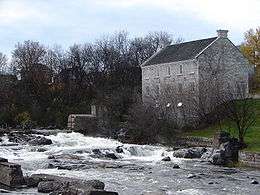


John Lorn McDougall, politician and fur trader, built the mill in 1855 by the Bonnechere River near the town landmark Swinging Bridge and overlooking natural rapids below the Renfrew Power Generation generating station. It has been converted into a museum, sometimes referred to as 'Renfrew Museum', not to be confused with museums of that name in Pennsylvania and Scotland. The McDougall Mill Museum houses pioneer tools and machinery, a military section, a doll exhibit, as well as toys, Victorian clothing and household items.[15]
See also
| Wikimedia Commons has media related to Renfrew, Ontario. |
| Wikivoyage has a travel guide for Renfrew. |
References
- 1 2 "Renfrew census profile". 2011 Census of Population. Statistics Canada. Retrieved 2012-02-10.
- ↑ MORRISON, K.L. "Renfrew". The Canadian Encyclopedia. Retrieved 4 April 2017.
- ↑ Natural Resources Canada (1957). "Climate Regions (Köppen) Map". The Atlas of Canada. Natural Resources Canada. Retrieved 2012-10-31.
- ↑ Environment Canada. "Canadian Climate Normals 1971-2000 – Renfrew, Ontario". Government of Canada. Retrieved 2012-10-31.
- ↑ "2016 Community Profiles". Canada 2016 Census. Statistics Canada. February 21, 2017.
- ↑ "2011 Community Profiles". Canada 2011 Census. Statistics Canada. July 5, 2013. Retrieved 2012-02-10.
- ↑ "2006 Community Profiles". Canada 2006 Census. Statistics Canada. March 30, 2011. Retrieved 2012-02-10.
- ↑ "2001 Community Profiles". Canada 2001 Census. Statistics Canada. February 17, 2012.
- ↑ Statistics Canada: 1996, 2001, 2006 census
- ↑ http://www12.statcan.gc.ca/census-recensement/2016/dp-pd/prof/details/page.cfm?Lang=E&Geo1=CSD&Code1=3547048&Geo2=PR&Code2=61&Data=Count&SearchText=Renfrew&SearchType=Begins&SearchPR=01&B1=All&TABID=1
- ↑ Renfrew County Fact Sheet – Renfrew Archived 2007-02-03 at the Wayback Machine.
- 1 2 Statistics Canada Community Profile - Renfrew - 2001
- ↑ http://www.nhlbirthplace.ca/
- ↑ 434 Squadron, Honors and Awards, citing Spence's Distinguished Flying Cross citation. Retrieved 2013-02-12.
- ↑ Ottawa Valley Guide: McDougall Mill. Retrieved 21 August 2007.
Further reading
- The Story of Renfrew. From the Coming of the First Settlers about 1820 to 1928. By W. E. Smallfield, Rev. Robert Campbell, D.Sc., William Smallfield, ISBN 1-894378-42-3
Places adjacent to Renfrew, Ontario | ||||||||||
|---|---|---|---|---|---|---|---|---|---|---|
| ||||||||||
| Cities | 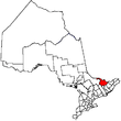 | |
|---|---|---|
| Towns | ||
| Townships | ||
| First Nations | ||
| Indian reserves | ||
| ||