Lac des Chats
| Lac des Chats | |
|---|---|
 | |
| Location | Ontario / Quebec, Canada |
| Coordinates | 45°31′02″N 76°29′37″W / 45.51722°N 76.49361°WCoordinates: 45°31′02″N 76°29′37″W / 45.51722°N 76.49361°W |
| Type | artificial |
| Primary inflows | Ottawa River |
| Primary outflows | Ottawa River |
| Basin countries | Canada |
| Settlements | Arnprior, Ontario |
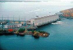
Lac des Chats (English: Lake of Cats), commonly known as Chats Lake,[1][2][3] is a lake on the Ottawa River that forms the boundary between the provinces of Ontario and Quebec (Canada).[4][5] It is formed by the Chats Falls Dam and serves as the reservoir for the Chats Falls Generating Station. Most of the lake is located in Pontiac Regional County Municipality, Quebec, and in Renfrew County, Ontario, but the easternmost part (near the dam) lies in Ottawa, Ontario and in Les Collines-de-l'Outaouais Regional County Municipality, Quebec.
See also
References
- ↑ Ottawa River Regulation Board, Shows name Chats Lake
- ↑ Changing Topography at Fitzroy Harbour, Chat Falls, etc., Several historical maps and sources showing use of Chats Lake or Chat's Lake
- ↑ Arnprior, McLachlin Trail
- ↑ "Lac des Chats". Geographical Names Data Base. Natural Resources Canada. Retrieved 2011-08-12.
- ↑ "Lac des Chats". Geographical Names Data Base. Natural Resources Canada. Retrieved 2011-08-12.
This article is issued from
Wikipedia.
The text is licensed under Creative Commons - Attribution - Sharealike.
Additional terms may apply for the media files.