Mastuj
| Mastuj Tehsil تحصیل مستوج | |
|---|---|
| Tehsil | |
 | |
 Mastuj Tehsil  Mastuj Tehsil | |
| Coordinates: 36°17′0″N 72°31′0″E / 36.28333°N 72.51667°ECoordinates: 36°17′0″N 72°31′0″E / 36.28333°N 72.51667°E | |
| Country |
|
| Province |
|
| District | Chitral |
| Headquarter | Buni |
| Government | |
| • Type | MPA |
| Elevation | 2,359 m (7,740 ft) |
| Population (2017)[1] | |
| • Total | 169,240 |
| Time zone | UTC+5 (PST) |
| Postal Index Number | 1710 - 0xx |
| Website |
www |
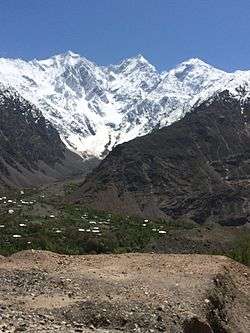
Mastuj (Urdu: مستوج) is a town and Tehsil of Chitral District in Khyber-Pakhtunkhwa province of Pakistan. It is located at 36°17'0N 72°31'0E with an altitude of 2359 metres (7742 feet). There are ruins of old fort built originally in 18th century and re constructed later couple of times.[2] [3]
Geography
Adjacent administrative units
- Wakhan District, Badakhshan Province, Afghanistan (north)
- Ishkoman Tehsil, Ghizer District, Gilgit-Baltistan (northeast)
- Yasin Tehsil, Ghizer District, Gilgit-Baltistan (east)
- Gupis Tehsil, Ghizer District, Gilgit-Baltistan (southeast)
- Behrain Tehsil, Swat District (southeast)
- Sharingal Tehsil, Upper Dir District (southwest)
- Chitral Tehsil (southwest)
Villages
The main villages include Buni, Mastuj, kargin, Marthing, Chuinj, Parkusap, Reshun, Parwak , Kuragh and Aveer. Mastuj is one of the most beautiful towns in Chitral. It is located at 36°17'0N 72°31'0E with an altitude of 2359 metres (7742 feet). Tehsil Mastuj starts right after the end of Baranis, Reshun, Kuragh, Buni, Aveer, Parwak, Mastuj, Chinar, Chuinj, Chapali, Kargin are the main areas of Tehsil Mastuj.[4]
See also
References
- ↑ "DISTRICT AND TEHSIL LEVEL POPULATION SUMMARY WITH REGION BREAKUP: KHYBER PAKHTUNKHWA" (PDF). Pakistan Bureau of Statistics. 2018-01-03. Retrieved 2018-04-23.
- ↑ http://www.hindukush.com.pk/index.php/mastij-fort
- ↑ http://www.chitraltoday.net/forts-in-chitral-the-manifestation-of-different-aspects-of-our-culture/
- ↑ Location of Mastuj - Falling Rain Genomics
Administrative divisions of Chitral District | ||
|---|---|---|
| Capital | ||
| Tehsils | ||
| Union councils | ||
This article is issued from
Wikipedia.
The text is licensed under Creative Commons - Attribution - Sharealike.
Additional terms may apply for the media files.